Walk Derbyshire – Howden & Derwent Reservoir Walk
Distance: 10.3 miles of easy road walking, mostly through woodland followed by a gravel track above Howden and Derwent Reservoirs. Recommended Map: Ordnance Survey Outdoor Leisure Series Sheet1; The Peak District, Dark Peak Area Public Transport: Hulleys and TM Travel 273, 274 & 275 Two Hour Service from Bakewell and Sheffield via Castleton and Bamford. Car Parking: Fairholmes Visitor Centre. N.B. Please note that the valley road is open to walkers, cyclists and horse riders, but it is closed to cars and motor cycles on Sundays and Bank Holidays from Easter to end October. Bus service from Bakewell, Sheffield via Castleton and Bamford (railway station). Refreshments: Fairholmes Visitor Centre. Although man-made, the flooded section of the Derwent Valley can vie with most of the English Lake District. Three reservoirs built over fifty years during the early to mid-twentieth century, have mellowed into an attractive amenity for all users. Trees planted at the same time as the reservoirs were built, have now matured and generally being of mixed varieties, make a perfect foil to a remote scene composed of water backed by wild moorland. Starting with Howden at the upper section of the valley, each dam and ancillary features such as culverts and filter beds, were built individually, one after the other gradually moving downstream. In order to accommodate the over a thousand-strong workforce, a village of corrugated iron huts was erected, catering for every need from groceries, to a doctor’s surgery and a barber’s shop. The village was known officially as Birchinlee, but soon found its way into the vernacular as ‘Tin Town’. The walk passes the site of Tin Town. Nothing remains of the actual buildings, but overgrown terraced ledges still mark the street pattern. A roadside plaque tells the story of a village that disappeared once its purpose was fulfilled. However, one of the corrugated iron buildings managed to survive, not above the reservoirs, but in Hope village where it serves as a ladies’ hairdresser’s salon. Another feature part of which can be traced on the ground, is the track bed of a light railway built to carry massive blocks of stone each weighing several tons, and destined to become part of the reservoir dam walls. It ran from a quarry near Bamford. During World War 2, because of its resemblance to the Mohne and Eder reservoirs in Germany’s industrial Ruhr, crews from the R.A.F’s 617 Squadron used Howden dam to hone their skills in dropping Barnes Wallace’s ‘bouncing bomb’. To do this the Lancaster bombers, based in Lincolnshire had to fly under cover of darkness in order to reach Howden. Using the twin towers of the dam as aiming points, the cylindrical bombs were skimmed along the water up to the dam, and then rolled down to it before exploding near its foot. In Germany the exploding bombs created pressure waves that destroyed the dam’s structure, releasing billions of tons of water to flood a vast part of the Ruhr industrial belt. There is a small museum commemorating the exploits of 617 Squadron, the ‘Dam Buster Squadron’, in the western tower of Derwent Dam. Ladybower, the largest and most southerly and last of the reservoir threesome was completed around 1945. The whole complex was officially opened by HRH King George VI who planted an oak tree now officially known as the King’s Tree. Growing steadily for seventy-five years near the end of the valley road, it has developed into a sturdy young memento of the king’s visit. This walk passes the tree on the final leg of the section above the west bank of both reservoirs. The track no longer has to cross the Derwent by hopping over a series of stepping stones, well known as Slippery Stones. The crossing is now done dry-shod, by way of the narrow pack-horse bridge that once stood near Ashopton village. When Ladybower reservoir was built, the village together with its hall and church had to be demolished (along with the dozen or so farms flooded by it and Derwent and Howden). To re-house families displaced by flooding the valley, a new village, Yorkshire Bridge, was built below Ladybower dam. At one time during droughts, the spire of Ashopton church appeared once more, but as it was considered a danger to anyone trying to get close, it was demolished. All that is left of the village are the twin gate stones standing at what was once the entrance drive to the hall, and the memorial plaque to Tip a faithful sheep dog who kept vigil over his master’s body when they were lost in a blizzard. The walk starts and finishes at the Peak District National Park Fairholmes Visitor Centre car park, close to the head of Derwent Reservoir. There are public toilets and a refreshments cabin available throughout the year. Please note that the valley road is closed to visiting cars and motor cycles on Sundays and Bank Holidays from Easter to the end of October. A bus service (Hulleys and TM Travel 273,274 & 275) runs from Bakewell and Sheffield, both via Castleton and Bamford every two hours. DIRECTIONS From Fairholmes car park, turn right on to the valley road, and start to follow it past the dam wall of Derwent Reservoir. Follow the road. Although traffic is light even during times when it is open to cars, please take care to be on the lookout for oncoming cars. As you walk beneath the mature trees on either side of the road, look for a series of terraces, the road layout of ‘Tin Town’, once the home of over a thousand navies and their families when they built the three reservoirs. There is a roadside plaque which tells the story of this long abandoned village. Passing the dam of Howden Reservoir, continue along the road and bear left, then right with it around the western arm of one of Howden’s feeder streams (Westend River). Continue along the road for a couple more miles until it reaches the King’s
Walk Derbyshire – Into The Past Through Five Historic Sites
History is everywhere with us in the Peak District. People have lived on and shaped the land for thousands of years, from the erectors of prehistoric standing stones and henges, right down to the current developments needed to house today’s expanding population. This walk touches a sample of five different ways the Peak has been affected throughout the centuries, each one leaving its mark as time moves on. The walk starts and finishes at Monyash, a small village on the limestone uplands, where farming is still the major occupation of many of its residents. Their predecessors left their mark when, in the eighteenth century, the Enclosure Acts allowed landowners to define field patterns, creating a maze of dry-stone walls typifying the Derbyshire landscape to this day. The next relic will probably be unnoticed, but the Roman road from Derby to Buxton will be crossed twice along the way. After crossing this road and its modern equivalent, the A515, a footpath drops down to the High Peak Trail, a walking and cycling track following part of the abandoned railway from Cromford to Buxton. Next comes the highlight of the walk, Arbor Low. Here is a stone circle built by our neolithic ancestors around 5,000 years ago, once the land became usable after the end of the Ice Age. Finally, the modern dairy and sheep farm at One Ash Grange started life as a monastic penitencery for recalcitrant monks from Roche Abbey near Rotherham. Alongside these five historical features, prehistoric burial mounds and capped lead mine shafts scattered around the fields were left by our recent ancestors, each and every one as well as us, leaving theirs and our mark on the landscape for good or bad. The walk is suitable for all weathers, and has gentle gradients throughout. At the start, the way is across tiny meadows and along green lanes. Beyond the A515, the few miles of level walking on the High Peak Trail are just made for striding out while enjoying the wide ranging views across the rolling Derbyshire limestone uplands. Next comes a short but unavoidable stretch of road walking. This is to reach Abor Low and also the turn-off for One Ash Grange Farm. Fortunately the normally quiet road between Parsley Hay and Youlgreave is generally used by local traffic, but never-the-less it should be walked with care. From One Ash Grange the way back to Monyash is along a footpath across a series of fields, eventually reaching one of the access roads into the village. When talking about the history of places and features along the walk, Monyash can claim to have its roots in prehistory. Situated in the heart of the White Peak, the limestone based part of the Peak District, where the villagers often had to carry water for miles, Monyash is uniquely endowed with four meres (five if you count filled-in Jack Mere, now the village car park). A ‘mere’ is the Derbyshire word for a man-made pond, used to store water. The meres owe their existence to a deep bed of watertight clay laid down at the end of the last ice-age some 10,000 years ago, making them possibly the oldest feature in the landscape. Monyash has a single pub, the Bull’s Head and next to it, the old smithy has been converted into a popular café. Narrow lanes radiate from the village green and footpaths seem to go in all directions. The village has access to Lathkill Dale. USEFUL INFORMATION DISTANCE: 9¼ miles (15km) of moderate walking on field paths, green lanes, historic railway trail and by-roads. Fairly level walking all the way. RECOMMENDED MAP: Ordnance Survey Outdoor Leisure Sheet OL24, White Peak Area. PUBLIC TRANSPORT: Hulleys Bakewell/Monyash 178 service Monday – Saturday, hourly service from 09:55. One bus only on Sunday & Bank Holidays, (177 Bakewell/Buxton via Monyash) at 11:50 out and 15:28 back. CAR PARKING: Jack Mere opposite the Methodist Chapel in Chapel Street, Monyash. REFRESHMENTS: Bull’s Head Inn and Smithy Café in Monyash. Light refreshments at Parsley Hay cycle hire and information centre. THE WALK From Jack Mere car park on Chapel Street, go through the adjacent stone stile and bearing left walk past the last of a row of cottages. The next section of the walk is across a series of narrow fields dating back to the Enclosure Act of 1771, defining shared plots in what were originally three huge communal fields. Bear half left away from the cottage and follow the grassy path using stiles in the stone boundary walls of seven narrow fields and an access track. Joining a farm track, turn right and follow it past a stone barn for about a quarter of a mile. At the junction of five tracks, turn sharply left and follow the walled-straight track for a little under one mile. Go past the donkey sanctuary and, on reaching the main A515 Buxton/Ashbourne road turn right towards the front of the Bull-I’-Thorn for four or five yards and then left. All the time on the lookout for speeding traffic, cross over, aiming for a signposted stile. The modern road is parallel to the Roman Road from Derby to Buxton and you will cross its position a yard or so after entering the first field beyond the A515. Go down the field to a stile next to a footpath sign. Cross this and bear half left, still downhill to the railway track. Climb up to the track and turn left. This is the High Peak Trail which is followed for a couple of miles. High Peak Trail follows part of the 33 mile Cromford and High Peak Railway, first opened in 1831 as a link between Cromford and High Peak Canal at Whaley Bridge. Built by canal engineers, it climbed steep inclines, the equivalent to canal locks, by using steam-powered cables; the stations were called wharfs. Parsley Hay cycle hire depot marks the end of this section of the walk. Call in for a coffee and then
Walk Derbyshire – A Winter Warmer Around the Longshaw Estate

I have to make an apology before embarking on the text for this walk. In July I acquired a new hip, this was after upwards of ten years trying to ignore an ever growing problem. Fortunately I had the sense to build up a stock-pile of walks, which kept Garry and Alistair happy at Images HQ, making it possible for them to publish my walks as and when necessary. Feeling a lot better since my session with Mr Williams, one of the osteopath surgeons on the staff at Calow Hospital where, I must add, I didn’t feel a thing, and was much entertained by what sounded like the opening bars of Giuseppe Verdi’s Anvil Chorus from his opera il Travatore! Deciding it was time to put my boots on again, I chose this walk mainly because it is short and finishes with the alternative of a pub lunch or the excellent soup and sandwiches on offer at the National Trust tea-room next to Longshaw Lodge. Using easy to follow paths through what was once a sporting estate, the walk drops down into the upper valley of Burbage Brook. Here it joins one of the ancient Pack-horse tracks that once linked Sheffield to the salt wells of Cheshire, and carried finished metal goods such as scythes on the return trip. With far reaching views throughout, the walk starts by skirting the front of the lodge, along a path between it and the open moors now grazed by sheep, but once the realm of sportsmen and their guns in search of game. Going through a swing gate, the path splits with one going south towards Big Moor, and the other bearing right, drops down to the Grindleford road. This is the one we took, going past an attractive pond, the haunt of wild geese. The path crosses the road by way of a stone stile and then finds its way down to Burbage Brook. An ancient stone packhorse bridge crosses the brook which is followed upstream to another stone bridge. Here a right turn joins a cobbled track winding its way up to the Grindleford road again. Diagonally right across the road there is a gate house and behind it a footpath through woodland back to the car park. Longshaw Estate and its lodge was built in the early 1800s for the Duke of Rutland as a sporting estate. During the Great War of 1914-1918 it became a military hospital, mainly for Commonwealth soldiers. From old photographs it looks as though many of the fitter soldiers managed to enjoy the heavy snowfalls that seem to have been more regular then than now. In the 1920s Longshaw was bought by Sheffield Corporation as an amenity for the city whose boundary cuts through part of the estate. While the lodge has been turned into private residences, the rest of the estate having been gifted to the National Trust, is open to all. The now famous Longshaw Sheepdog Trials take place annually in the large field below the main house. The Walk : From the National Trust car park, follow the path down to the National Trust tea-room and Information Centre. Bear right and then left on to the path running between the lodge surrounds and open fields. Follow this path up to a swing gate next to wild rhododendrons. To your left as you walk along the first path, the raised wall apparently supporting the ground above it is called a ‘ha, ha’, or ‘haw, haw’. Its purpose is to prevent stock from encroaching the built-up area surrounding the lodge, but without spoiling the extensive moorland view. Reaching the gate, go through it, bearing right alongside rhododendron bushes, where pheasants are often sheltering. Wooden signs at the side of the path point to where children might find places where friendly boggarts live. Continue along this path until it reaches a large pond. Skirt round the pond with it on your right and then bear left past the second stone barn before you reach the road. It usefully serves as a shelter in wet weather, as well as offering information about the surrounding countryside and its wildlife. Cross the road and go through a stone stile and then drop down to a stone pack-horse bridge over the narrow brook. Cross the bridge and turn right, upstream for about a quarter of a mile, as far as the next bridge. Turn right and cross the narrow bridge. Follow a cobbled path, winding steeply uphill and through woodland as far as the road Go diagonally across the road, heading towards a gate house. Follow signs past the gate house and onto a woodland track. Continue along the track back to the National Trust car park Useful Information : 3miles (5km) of easy walking on well-maintained estate paths and riverside and woodland tracks. Recommended map: as the walk cuts through the northern and southern edges of both the OS White Peak (Sheet OL24) and OS Dark Peak (Sheet OL1) maps, it can make map oriented navigation rather difficult, but hopefully my poor quality sketch map and written instructions will be sufficient. Public transport: Regular service between Sheffield and Grindleford stop at the Fox House Inn a few yards from the entrance to Longshaw Estate. Parking: Inside estate (National Trust members free). Refreshments: Fox House Inn and Longshaw tea-room and Information Centre. Annual sheep dog trials as advertised. Guided walks and seasonal children’s events throughout the year. +10
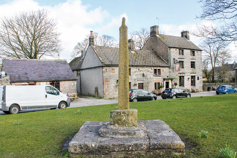
Walk Derbyshire – Foolow & Silly Dale

There are no records of any simpleton, either in Foolow or Silly Dale; both names come from Anglo Saxon English and have entirely different meanings than in today’s language. Foolow means multi-coloured hill, possibly a reference to nearby Eyam Edge. Silly is Old English for pretty, an apt description of this little-known dale, especially in late spring when the limestone-loving flowers are in full bloom. The walk starts and finishes in Foolow, a village of light grey limestone cottages, arguably the most picturesque in the Peak District National Park. There is a bay-windowed manor house and the Bull’s Head offers an excellent menu to satisfy the hunger of the hardiest walker. Until 1888 when the tiny limestone church dedicated to St Hugh was opened, church-goers congregated around the ancient stone cross and its pagan bull-ring standing next to the duck pond. Until 1932 when pipes were laid, water was a problem in this upland village. Before then villagers had to collect water from a well a little way along the Hucklow Edge road above the village. Cattle enjoyed the convenience of the attractive duck pond on the village green and in celebration of the gift of water, village wells have been dressed since 1983 on the Saturday prior to the last Sunday in August. Starting from Foolow the walk climbs up to Hucklow Edge before turning west and descending to the neighbouring village of Great Hucklow. This village, clustered around its pub, the Queen Anne, is really a group of five inter-linked hamlets where lead miners delving 600 feet beneath the ground, worked the riches of High Rake, following a series of inter-connected veins running north-westwards. Pack Horse teams once carried the ore together with Cheshire salt across the high limestone moorland, by trackways that can still be traced for miles. From 1938 until 1970, the playwright L du Garde Peach produced plays in the popular Playhouse theatre, based on an old barn in the village. Beyond Hucklow, the walk descends into Silly Dale and, on climbing out of it, crosses a series of green fields back to Foolow. Useful Information 3miles (5km) of easy walking along rural lanes, field paths and a flowery dale. Recommended map: Ordnance Survey 1:25000 scale Outdoor Leisure map The Peak District – White Peak Area Sheet 24. Refreshments: Bull’s Head (Foolow), Queen Anne (great Hucklow), pubs and cafes in Eyam. Public Transport: TM Travel 65 service from Sheffield and Calver Sough runs hourly Monday/Saturday and two hourly on Sunday. G&J Holmes/Hulleys 66 service between Buxton and Chesterfield runs two hourly from Chesterfield Monday/Saturday and three hourly on Sunday. Parking: roadside around Foolow village, but please do not block local access. The Walk : With your back to the duck pond in Foolow, take the road past the church and head towards Hucklow Edge. Follow this road for just under a mile. The old village well at the side of the road to your left is protected by a wall with a narrow stile to keep animals away from the one-time sole drinking water supply for Foolow, once a scarcity on these dry limestone uplands. Regrettably the water is now unfit for human consumption. Just before the road begins to climb steeply and bears right towards Hucklow Edge, turn left and cross a stone stile in order to follow a wall-side path. Gliders from the Gliding Club behind the edge can usually be seen soaring gracefully on the up-sweeping currents of air. Tree-lined hollows and rough ground uphill towards the edge indicate the position of abandoned lead-mining activity. Joining a narrow lane turn left and follow it until it reaches a side road. Turn left along the road, following it below a belt of trees. At the far end of the woods, turn left over a stile and follow waymarking arrows and splashes of paint down into the Grindlow section of Great Hucklow. Bear left along the village road and then fork right towards the main road. Cross the road diagonally left and right, then go to the left of a single bungalow. Follow the narrow, walled track, down into Silly Dale. Surface water has not flowed down Silly Dale for at least 10,000 years, when catastrophic floods marked the end of the last Ice Age. Flowers growing along the dale include white meadow saxifrage, purple cranesbill and spotted orchids. Turn left at the T-junction marking the dale end and cross over to the opposite side of the dale. Go to the left over a stile, and bear right and then half left, uphill. Following stiles cross nine increasingly narrow fields as you near the village, all the way back into Foolow, entering the village by going past the Manor House in order to reach the duck pond. Foolow is built around a wide village green with the highly photogenic duck pond as its centre point. A fourteenth-century cross and a bull-ring-stone are on the far side of the pond. Better still is the Bull’s Head pub a few yards further along the Eyam road to your right [wpgmza id=”37″] 00
Derbyshire Walk – An Alpine-style walk around Matlock Bath

On a sunny weekend today’s Matlock Bath is popular with middle-aged motorcyclists whose expensive mounts line the riverside frontage. They are just the modern manifestation of the visitors who come to enjoy the local scenery. As far back as the Georgian era, people have come to admire the unique setting of this small village: at first it was only visited by those who could afford the expense of horse-drawn transport, but when the railway came, and with it cheaper transport, it opened up the place for those with lighter purses. Since then the coming of the motor car has spread the net and people flock from all over the north Midlands for a day out in this mini-holiday resort. Early visitors likened Matlock Bath to an alpine resort, and that cannot be far from the truth. Romantic poet Lord Byron described Matlock Bath as; ‘There are places in Derbyshire rivalling Switzerland and Greece’. A bit far fetched, but with the vertical limestone crag of High Tor and its continuing ridge opposite the main part of the village, the aspect is not far removed from some alpine village – admittedly not quite as high, but nevertheless the looks are there. The ambience is continued with the cable car up to the Heights of Abraham and its terraced woodland walks. There’s even a tiny chapel, St John’s, about half way between Matlock and Matlock Bath that could easily be mistaken for a miniature Alpine Schloss. Probably the closest to a truly alpine footpath is the path along what is known as ‘Giddy Edge’. This path, complete with a metal handrail crosses the upper face of High Tor and can truly be compared – again, in a small way, to Via Ferrate the iron ladders that criss-cross the Dolomites and other limestone mountains of the Alps. This walk uses many of the high-level and riverside paths that wander high and low around the village. Starting at Matlock Bath railway station the walk climbs up the side of High Tor into the outskirts of Snitterton. This linear satellite village follows what was once the only road south from Matlock until the line of the A6 was developed. Entering woodland, the path climbs to the summit of High Tor, where the exciting prospect of the Giddy Edge path begins its descent back into Matlock Bath. Here if you want, a truly alpine extension to the walk can be made by taking the cable car to the top of the Heights of Abraham and enjoy its woodland walks. (Visit www.heightsofabraham.com for opening times) Continuing towards the riverside section of the walk, a footpath leaving the car park climbs to the ridge-top continuation of High Tor, before dropping down to the river by a series of well-laid steps. A left turn at the river will follow the wooded path called ‘Lovers’ Walk’ until it reaches a modern footbridge. Over this are the Riverside Gardens and beyond is the Pavilion, the restored replica of an alpine Kursall, or spa. The fascinating Peak District Lead Mining Museum is here together with a friendly café dispensing home-made food. There are many alternatives for refreshments along the roadside, ranging from fish and chips to several excellent restaurants and pubs. A WORD OF CAUTION While the Giddy Edge section of the walk has a well-placed handrail, it should be approached with great care and certainly not in wet or icy conditions. For anyone not wishing to use the Giddy Edge path, there is an alternative route bearing left at the start of the edge path which crosses the highest point of High Tor. Children and dogs must be under close scrutiny at all times. The Walk Take the side road parallel to both the river and railway line, away from the car park. Turn right and go under the railway, uphill towards the entrance to the bottom station of the Heights of Abraham cable car. Do not bear left to the cable car entrance, but continue ahead and through a squeezer stile next to a metal gate. Climb the roughly surfaced track until it reaches an unmade road lined with houses. Turn left on this road and go through a gate opening on to a surfaced track leading into woodland. The track climbs steadily, bearing right in its upper reaches. Where the track on leaving the trees bears left, continue ahead until it peters out. (The track going left is heading for a radio mast). The woodland is part of the High Tor Recreation Grounds. There are several roofless old mines around the summit, often bearing fanciful names such as ‘Fern Cave’ or ‘Roman Cave’, but none are quite so ancient. It was once possible to enter the mines for self-exploration, but an over-cautious council has closed them off on Health and Safety grounds. There was once a café on the summit of High Tor, but it mysteriously burned down within a few days of its closure. Swing round to the left away from the mast compound and make for the summit of High Tor to admire the view. N.B. There is no barrier at the summit, so keep well away from the edge – there is a 190 foot drop straight down the tor face. Bear left away from the summit rocks and follow the signpost towards Giddy Edge, making use of the iron handrails as necessary. N.B. If it’s icy, raining or if you do not have a head for heights, bear left away from the start of the Giddy Edge path and go over the highest point of High Tor. This path joins the Giddy Edge path on the far side of the summit. Continue on the edge path, using a well-placed seat for a rest along the way. At the far end, join a rough path zig-zagging steeply downhill through mature woodland. Go to the left and then right around the perimeter fence of the cable car. Go under the railway bridge and turn left on to