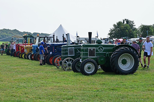
DRIVERS REMINDED NOT TO PARK ON MARKET PLACE AS EVENTS BEGIN

Drivers in Ashbourne are being reminded not to park on the town’s Market Place, as events begin following the recent restoration and pedestrianisation of the area. Parking tickets are being issued to those who ignore the new restrictions. As part of the UK Government funded Ashbourne Reborn transformation programme, Grade II listed surfaces have been repaired and restored, new street furniture added and trees planted to bring much-needed greenery into the town centre. On 31 January, Ashbourne Makers Market moved to its new regular home on the Market Place, and this is expected to be followed by a series of both new and familiar events throughout the year. The programme is being developed by local partners including the Town Team and Ashbourne Town Council, and will build on popular events like StreetFest and the Lantern Parade. Despite signage informing drivers that the Market Place is no longer a car park, a small number of vehicles are persisting in using the pedestrianised area. The District Council are reminding drivers that enforcement is in place, and those drivers that continue to ignore parking restrictions risk receiving a parking ticket. A spokesperson for the District Council said: “Representatives of local business and the community have been clear since the Government funding bid was submitted that they want the Market Place to be used as a public space and for events. To make sure this can happen, we will be enforcing the new parking restrictions and drivers risk receiving a ticket if they park on the Market Place. “There is plenty of alternative parking in Ashbourne, as well short-stay spaces, including two disabled bays, around the edges of the Market Place for visits to local businesses.” Nearby car parks including the Cattle Market Car Park, Ashbourne DE6 1ED (0.2 miles from the Market Place), reduced to a flat rate of £2 per day, Shawcroft Car Park, Ashbourne, DE6 1GD (0.2 miles from the Market Place) and Bus Station Car Park, Ashbourne, DE6 1BW (0.3 miles from the Market Place). The Highways and Public Realm project is transforming the historic town centre with wider pavements, clearer pedestrian crossings and improved public spaces. It is led by the County Council, with contractors Galliford Try carrying out works on their behalf. A second major project to develop The Link Centre, led by Ashbourne Methodist Church, is due to open mid-2026. The new community hub will host a series of cultural events throughout the year as well as providing a range of new services to residents, businesses and visitors in Ashbourne. Derbyshire Dales District Council is the Accountable Body for Ashbourne Reborn, Derbyshire County Council is responsible for delivering the Highways and Public Realm project and Ashbourne Methodist Church the Link Community Hub. These partners work in collaboration with Ashbourne Town Team, Ashbourne Town Council and AshCom who brought forward proposals, identified opportunities and raised match funding for the original bid. To receive email updates, sign up for the newsletter at the District Council website www.derbyshiredales.gov.uk/enewsreg (tick the box for Ashbourne Reborn), or visit the Ashbourne Reborn website www.ashbournereborn.co.uk for the latest news, FAQs and detailed information about the project. 00
Derby Museums Launches a ‘Year of Wright’ (2025-26) in London, Derby and online
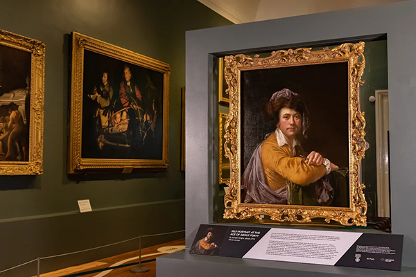
Discover the city that shaped one of the UK’s most original and visionary painters Derby Museums is delighted to announce The Year of Wright — a year-long celebration of the life, art, and enduring relevance of Joseph Wright of Derby (1734–1797), one of Britain’s most original and visionary painters. Derby Museums’ collaboration with The National Gallery, London Joseph Wright: From the Shadows opened in November 2025,and now audiences in London, Derby, and around the world online are invited to rediscover Wright’s art, and his radical curiosity, by taking a closer look at the remarkable city that inspired him – Derby. Often seen as the birthplace of the Industrial Revolution, as well as a centre for cultural and scientific innovation, the city formed a key part of Wright’s creative inspiration, and it was in his studio there where his many ideas came together and were committed to canvas. Everyone from academics to artists and first-time museum visitors are invited to discover this iconic 18th century artist and his world with fresh eyes. Why Derby? Because there is no Wright without Derby The city was Wright’s lifelong home, the setting for many of his most famous paintings, and a major centre of the 18th-century scientific and industrial networks that fuelled his imagination. He was a painter of huge versatility, and it is hoped people will discover or re-discover him as part of the Year of Wright. Today, the city remains the only place in the world where visitors can experience Wright’s art in the context of his life and world. Derby Museums holds the world’s largest collection of his work – paintings, drawings, letters, and artefacts – that reveal his close friendships with a broad range of people from all walks of life who influenced his thinking and his art. This ranged from thinkers, industrialists and scientists to fellow artists, poets and writers. Visitors will be able to step into Wright’s Derby through a specially curated weekend itinerary in partnership with Visit Derby, exploring the city’s links to Wright and how it inspired him through vibrant museums, historic architecture, riverside mills, and even a new locally brewed beer inspired by the artist himself. A campaign to encourage visitors to both The National Gallery and Derby Museums will run in 2026. Using images of Wright in unexpected ways it will encourage people to ‘see the bigger picture’ and ‘get up close and personal’ to this sometimes-enigmatic character, through his art and the city he lived in. ‘Derby isn’t just where Wright was born — it’s where his ideas were forged and committed to canvas,’ says Lucy Bamford, Curator at Derby Museums. ‘Wright is known throughout the world for his illusionistic depictions of light and darkness. For many people, these works have come to symbolise a world on the brink of modernity, but they also reveal an artist grappling with enduring and fundamental themes about nature and the human experience.’ ‘The ‘Year of Wright’ was inspired by the only known portrait in which Wright shows himself as an artist, Self Portrait at the Age of About Forty (c.1772), which was acquired for the nation by Derby Museums in 2022. Spanning the full breadth of Wright’s life and career, we really hope the activities and exhibitions throughout the year will inspire people to look again at the man behind the paintings, what inspired him and just how versatile and groundbreaking he really was – it is time to take a closer look.’ Highlights of the Year of Wright (2025–2026) Two major exhibitions in London and Derby Wright of Derby: From the ShadowsThe National Gallery, London: 7 November 2025 – 10 May 2026Derby Museum and Art Gallery: 13 June – 1 November 2026 The first major exhibition devoted to Wright’s celebrated candlelight paintings, From the Shadows explores and looks again at his most admired works. Seventeen of the twenty works in the show are from Derby Museums’ collections. Illuminated faces gather around a variety of objects – from classical sculptures and scientific instruments to bones, bladders and animals. Through his unflinching scenes of people watching, Wright proposes moral questions about acts of looking. The strong light and deep shadows create drama, reminding us of great painters from earlier centuries like Caravaggio. Curated by Christine Riding (National Gallery) and Lucy Bamford (Derby Museums), the show opened in London this November. Joseph Wright of Derby: Life on PaperDerby Museum and Art Gallery: 12 March – 17 May 2026 Reopening by popular demand following an initial presentation in summer 2025, this exhibition includes some of Wright’s earliest known works, made as a young teenager. It also assembles more than 70 of Wright’s, until this year, largely overlooked, personal drawings, sketches and letters, spanning the full breadth of the artist’s life and career. The exhibition is curated by Lucy Bamford (Derby Museums) and it is accompanied by a full illustrated catalogue. A new discovery for the UK – now on display in Derby A previously unknown portrait by Wright, found in a family home in the Scottish Borders in 2024, is now on display at Derby Museum and Art Gallery. The painting has been dated c.1760 and depicts the artist’s friend Edward Miller (1735 – 1807), a prominent composer who in his youth played flute in the orchestra of the famous German composer George Frederic Handel. It adds a new dimension to our understanding of Wright’s friendships and artistic network. Derby Museums’ Senior Curator of Art and the Joseph Wright Collection, Lucy Bamford, worked in partnership with Dr Martin Postle (Paul Mellon Centre for Studies in British Art) and Historian Dr Stephen Leach to authenticate the portrait. The world’s greatest Wright collection – launching early 2026 For the first time, global audiences will be able to explore Derby Museums’ Joseph Wright Collection — the world’s largest and most comprehensive resource on the artist — entirely free online. Featuring almost 600 objects, from paintings to letters and personal effects, the collection has been digitally catalogued with support from the Paul Mellon Centre, offering unprecedented public access and research opportunities. Much of the
Severn Trent partnership brings life back to damaged moorland landscapes
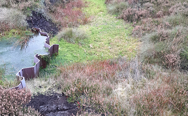
Since the time of the Industrial Revolution, the moorlands of the Peak District and South Pennines have been suffering from the legacy of centuries of pollution from the coal-fired factories that once surrounded them. However, these precious landscapes are gradually being brought back to life, thanks to organisations working in partnership to reverse this damage. And, while this work has achieved great improvements in the last 20 years, there is still work to be done to ensure these habitats can look after themselves Once-desolate hilltops have become green again, thanks to a combination of keeping them wetter and planting moorland plants. This landscape-scale transformation couldn’t have happened without human intervention, funded by a range of partners, both public and private. But the work isn’t complete yet. Vast expanses of bare peat may largely be a thing of the past, but only by continuing the work to re-store wetter conditions and by planting the amazing sphagnum moss in these restored areas can they begin to look after themselves. Since 2015 Severn Trent have been part of a partnership, restoring life to large areas of the Peak District and South Pennine moors. These precious moorlands were damaged by the pollution of the Industrial Revolution and it is through partnership working that these habitats have been brought back to life. Around eight million people across the Midlands receive their water and sewerage services from the company, activities which lay the foundation for Severn Trent’s extensive work in the conservation of landscape and biodiversity. 70% of the drinking water in the UK begins its journey into reservoirs from remote upland areas like the Peak District. For the past decade, Severn Trent – which has been part of the Moors for the Future Partnership since 2015 – has invested in the condition of the habitats within the Bamford Catchment – the area around the Derwent Valley and Ladybower Reservoirs – which sits within the protected landscape of the Peak District National Park and the South Pennine Moors Special Area of Conservation (SAC). This has included working in collaboration for shared outcomes with multiple partner members of Moors for the Future Partnership, including the National Trust. This collaboration has seen landscape-scale outcomes achieved for nature recovery in the High Peak through successive projects including, most recently, the Moor Water project (2020–25). The project set out to build on the achievements of earlier collaborations to restore blanket bog, re-establishing the characteristic plant and moss diversity of these habitats, and thus providing a better home for nature on the moors. Bringing life back to the moors also brings other benefits: it improves the quality of the water running into the reservoirs and slows the flow of water from the hills during storm events, contributing to water security and natural flood management in a changing climate. Before the works began, blanket bogs in this area had been badly damaged by 200 years of atmospheric pollution, as well as a host of other factors. This had led to a severe loss of vegetation on the moorland plateaux, resulting in vast areas of bare peat exposed to the elements. Thanks to this essential project, the moors are being revived for generations to come. The Moor Water project began in 2020 and in the last five years, the Partnership has: Following the success of the Moor Water and Great Big Nature Boost projects, the Partnership is looking forward to a new, five-year period of moorland restoration, science & monitoring and communications, which will begin in the coming weeks and months. Matt Scott-Campbell, Partnership Manager at Moors for the Future Partnership said: “Through our Partners’ ongoing commitment to collaborative working the Moor Water project with our Partners Severn Trent has enabled the Partnership to continue its work towards our shared vision of a sustainable and resilient upland landscape for the Peak District and South Pennines. This successful collaboration has once again seen positive investment into the long-term recovery and improving condition of a significant area of degraded blanket blog, building on our shared achievements to date. Our collective efforts for nature, people and place remain vital in the face of climate change, and we look forward to working in close Partnership Severn Trent Water into the future as we continue together.” Samantha Wilson, Environmental Comms Lead at Severn Trent said: “We’re proud to have played our part in restoring these incredible landscapes over the last decade, which are vital for nature and water quality. Healthy moorlands don’t just look beautiful, they help store carbon, slow the flow of water and protect the habitats that make the Peak District so special and an integral part of our community. It’s a real privilege to continue to work collaboratively in this way and means we can achieve so much more together. We’re committed to continuing this work so these moors thrive for generations to come and look forward to this ongoing this valuable partnership.” 00
The Lost Houses of Derbyshire – Hoon Hall

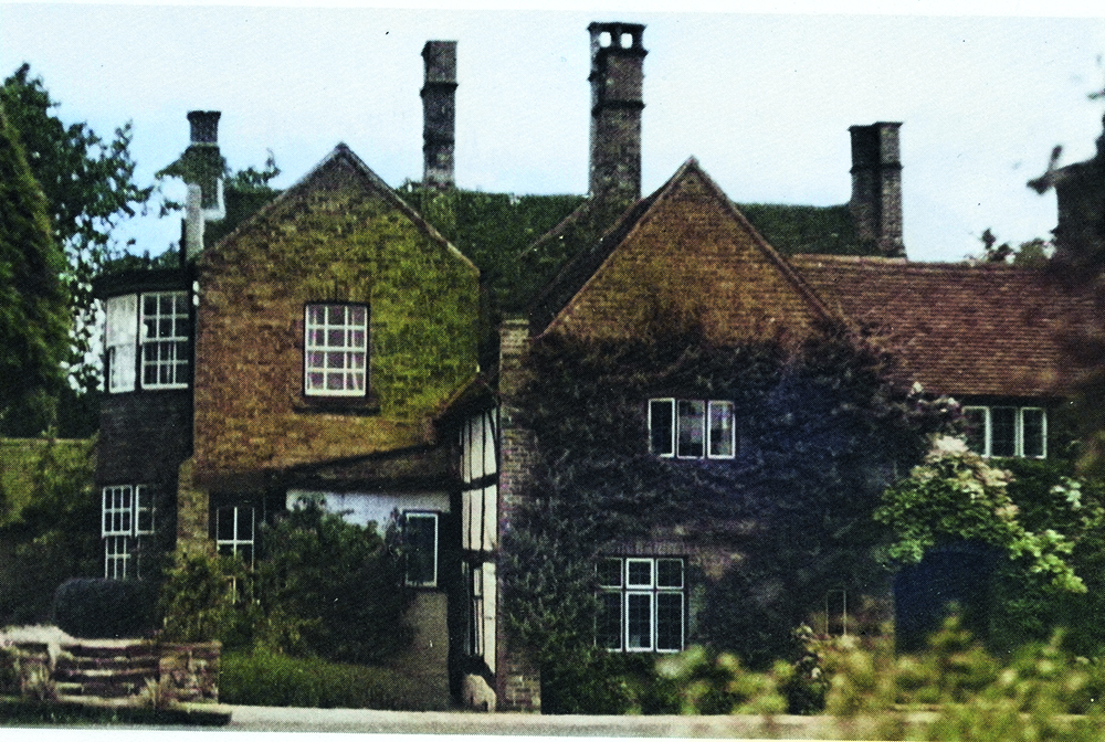
By Maxwell Craven Hoon is a strange little place, a civil parish created from the larger ecclesiastical parish of Marston-on-Dove by some zealous bureaucrat in the early 20th century, which stretches from the low hills on the north side of the Dove down to the river itself, yet is barely a mile and a half wide, east to west. It was called ‘Hougen’ in 1086, when there were two manorial estates there, one of which was given to the Abbey of Burton and the other, which was granted to the Norse-descended grandee Saswalo or Sewallis, ancestor of the Shirley family. The name itself derives from the old Englishword (in the ablative) for ‘by the barrows’, and indeed a large barrow – presumably Bronze Age – survives to this day. The name later mutated to ‘Howen’ and ‘Hone’ before the OS settled on the present spelling in the earlier 19th century, suggesting that the name was traditionally pronounced with an ’oh’ sound instead of an ‘oo’ one as its current spelling would suggest. The Shirley family held the estate until 1559 when George Shirley of Staunton Harold sold Hoon to Roger Palmer of Kegworth, whose grandson, Robert, lived at Church Broughton, when he is said to have built the first hall in 1624. We know little about the house, but it must have been very modest, for it is unlocatable in the 1670 hearth tax returns, although by that date, it had been sold to John Stafford of Blatherwick in Northamptonshire who in turn had sold it on during the Civil War. The purchaser in those lean and uncertain times was Robert Pye (1585-1662), who, it must be confessed, shared a common ancestry with your author, from the Pyes of The Mynde and Kilpeck in Herefordshire. Indeed, I had a kinsman who even bore the Pye name as his given name: I used to joke that it was a mercy the names were not deployed the other way round, strongly suggesting some dubious comestible. Pye was a Royalist and had been nominated as a baronet on the outbreak of civil strife by Charles I but, with the upheavals, the honour failed to pass the Great Seal, and it was his son John (1626-1697) who, after the Restoration, did actually receive a baronetcy. Normally, in those circumstances (as with the Boothbys of Broadlow Ash) the baronetcy would have been confirmed to the father (alive or dead) but, as the elder son had been a keen Parliamentary commander, this idea failed to find favour with Charles II, so John received a fresh baronetcy – of Hoon, where he then lived. The house of 1624 was probably timber framed, for in 1816 the Lysons described it as ‘an ancient half timbered building’. However, the latter add that it had ‘pointed gables’ and our only picture, a woodcut of 1892, shows just that, three of them, but with any timber framing stuccoed over. It also shows a pretty modest house – a farmhouse – with early 19th century cambered headed casement windows in place of the mullion and transom cross windows that must originally have graced the façade. Furthermore, the fenestration is clustered centrally, suggesting that, when the house was adapted as a tenanted farm, it underwent a drastic reduction and a re-façading, possibly even in brick, where previously there had been timber framing. There were almost certainly cross-wings at each end of the façade, the loss of which might have necessitated the change to the fenestration and its disposition that we see in the drawing. The somewhat complex subsequent history of the house does throw some light on the matter, however. Sir Robert soon after moved to Faringdon, where he had acquired a larger property, to which he repaired, leaving his son, Charles, to go and live at Hoon after he came of age in 1672, although he was later described as ‘of Derby’ in 1713. He died in 1721, and his son only three years later, leaving it to his grandson, the dilletante Sir Robert, 4th Bt., but who lived at Clifton Campville, Staffordshire, leaving Hoon Hall empty after 1724, when he succeeded. Sir Robert died in 1734 aged only 38 leaving no male heir , whereupon the baronetcy became extinct. His heiress had married Thomas Severne, whose son died in 1787 leaving the estate to Charles Watkins of Aynho, Northamptonshire. Watkins, like the Pyes, had little need of Hoon Hall and he is the one who reduced it, sometime prior to 1812, when he died, leaving the – now tenanted – farm and estate to a kinsman. That kinsman, however, brings us almost full circle, for ironically he was Henry John Pye of Clifton Campville, who had just succeeded his father there. The father, Henry James Pye MP (1745-1813) was a descendant of then first Sir Robert Pye’s Cromwellian brother, Robert, who was excluded from the grant of the by then extinct baronetcy, but who had succeeded to all the other Pye properties except Hoon, in 1734. H. J. Pye the elder is also of interest because from 1790 until his death in 1813, he had been poet laureate, a position he had been given not for being in the slightest bit talented as a poet, but in exchange for political favours toward William Pitt the younger, the prime minister. Pye was the first poet laureate to receive a fixed salary of £270 instead of the historic tierce of Canary wine – Madeira to you and me, these days a rather unfashionable drink. Nevertheless, young Henry Pye’s ownership of the estate was relatively brief for, being so far from his other properties, it was difficult in those days to administer and the house, of course, was by this time a working farmhouse. He therefore sold it to the Derby attorney William Jeffrey Lockett the younger (see Lockett’s House, Derby, Country Images, May 2022). Lockett died unmarried in 1848 aged 51, whereupon the house and farm were sold to Thomas Orme from whom
The Lost Houses of Derbyshire – Ockbrook Manor
by Maxwell Craven Ockbrook Manor was a wonderful old house which one could only describe as ‘multi-period’ having, seemingly a portion of its fabric from virtually every post-modern era. The other thing is, that by being called ‘Manor’, one might assume that it was the capital mansion of an estate going back well into the Medieval period, yet that is not quite true either. It is well known that Ockbrook was granted by William I to Geoffrey Hanselin, from whom the estate had passed, by 1290, to Hugh, 1st Lord Bardolph, whose son was recorded as having a park there. The Lords Bardolph lived at Wormegay in Norfolk as their principal seat, but the fact that they had a park presumably suggests that they used Ockbrook as a hunting lodge. At some stage, too, much of the land had been granted by the Hanselins to Dale Abbey. In 1358 John, 3rd Lord Bardolph, sold the manorial rights and his Dale tenancy to Sir Godfrey Foljambe of Tideswell, whose seat and prolific lead interests remained in the north of the county. This suggests that any hunting lodge at Ockbrook was either abandoned or let, either to a bailiff or to a sub-tenant, although any such detail remains elusive. The Foljambes’ estates passed eventually to Yorkshire grandee Sir William Plumpton, who died in 1481 from whom Ockbrook came to Sir Thomas Seymour. He sold it to Sir Andrew Windsor, created 1st Lord Windsor (ancestor of the present Earl of Plymouth) and in due time, Frederick, 4th Lord Windsor, succeeding to the family estates in 1559, sold the manorial rights to the resident freeholders of the village. Meanwhile, when Dale Abbey was dissolved in 1536, their land at Ockbrook was acquired by Francis Pole of Langley whose posterity also sold it to the Stanhopes of Elvaston. The freeholders who bought the land and shares of the manor from Lord Windsor included several local families who remained in the village until the early 20th century: Battelle, Columbell, Piggen and Windley. The purchasers of the land on which stood the original manor house (and three shares of the manorial rights) were the Piggens, They almost certainly built the first residential capital mansion on the site – although whether their new house actually stood on the ancient site is impossible to tell – and a timber box-framed wing remained embedded in the fabric until the house was eventually demolished dated from this mid-Tudor period. The site was on the NE angle of the junction between Church Lane, The Riddings and Bare Lane, 150 yards due north of the church, a proximity that might suggest that it was indeed built on the ancient manorial site. We get an indication of the size of the house from the 1664 hearth tax record, which shows Richard Piggen assessed for tax on three hearths, which suggests something pretty modest: possibly there was still the great hall, open to the rafters with a large hearth, a parlour with chamber above providing the other two. Not long after Richard Piggen’s time, the house was rebuilt and enlarged by his successor in brick, two gabled two storey ranges being added to the SE front between which lay the front door. This probably led into the former great hall, which this rebuilding would have floored over to provide two chambers above it. The new gables were straight and coped with stone and included chimney shafts, latterly drafted by the addition of flat tops raided on stone slabs set on end, giving the skyline a distinct profile. In 1713 the Keys family of Hopwell Hall acquired Piggen’s three shares of the manorial estate and his land, and incorporated it into their Hopwell estate, and it then descended as a tenanted farm, first to Henry Thornhill and then to Sir Bibye Lake, Bt. who, in 1786, sold the estate to Thomas Pares, a rich Leicester tradesman. The Pares family were great improvers of their estate, and in the Regency period they rebuilt the old house to improve its viability. They added a short two storey service range and put in sashes where previously there were mullion and transom cross windows with casements, although they left the old timber framed wing alone bar up-grading the original mullioned casements. The reason for this up-grading was not so much to improve it as a farm house, but to make it suitable with a view to letting to Derby businessmen and gentlemen, keen to rent a villa as near as possible to Derby but far enough away from the rapidly increasing smoke and grime of Derby’s foundries. The first tenant, as it happens, was Bryan Thomas Balguy, the second son of John Balguy of Duffield Park (pronounced ‘bawgy’), a descendant of the Bulguys of Derwent Hall. The father had become an Alfreton coal-owner but was professionally a barrister and a very eminent judge. Bryan Thomas (1785-1857) was also a barrister and in 1818 was appointed Town Clerk of Derby and as a result, he built Field House Spondon (see Country Images June 2021) needing a house within striking distance of the Guildhall at Derby. Bryan Balguy married a young wife, Emma Broadhurst Portmore (who was born in Duffield in 1808) in London in 1827 when he was 42 and she was 19. It seems likely either that she disliked Spondon (how could she?) or she fell out with the locals, for he sold Field House in 1829 and moved to Ockbrook Manor, on which he took a long lease from, the Pares family, whose lawyer he (conveniently) was. He obviously missed the double Regency bowed façade of Field House, and promptly made alterations to the Manor, including on the SEW side – a full height Regency bow. He was obviously not satisfied with the three sashes to each bow fitted to his old house in Spondon, so at Ockbrook he crammed in five sashes per floor to the bow, dividing them with hung tiles, a very un-Derbyshire conceit
The Lost Houses of Derbyshire – Beaufort House, Derby

By Maxwell Craven “Some years ago, a friend who is a keen collector of local postcards, Don Gwinnett, sent me a copy of a postcard of a delightful house with Gothic windows, labelled Cowsley Fields. I loved the look of the house, and decided to try and identify it, which I may say I had great difficulty in doing. Being on the edge of Chaddesden and just down the slope from the termination of the memorable Stanley Footrill Colliery Tramway, but (just) within the Borough boundary, I consulted Peter Cholerton, who has researched and understood the history of Chaddesden most thoroughly, and he was very helpful.” What emerges is that this photograph is of Beaufort House in Cowsley Fields – the area due north of Nottingham Road, abutting the cricket ground/racecourse (as was) and a few hundred yards north east of St. Mark’s Church – hence, of course, Beaufort Street, which runs N-S across the site, and is the only street in the area not named after a British or Irish county. We came to the conclusion that the name on the card got there because the house lay in Cowsley Fields and not because it was itself called that, although it wasn’t called Beaufort House either prior to 1853. Nearby Cowsley Field House and Cowsley Farm (also long vanished) looked completely different. Peter told me that by 1853 the house was The Pavilion Tea Gardens, built as a place of public resort and refreshment which faced west and would have provided a pleasant view across the racecourse. The racecourse at Derby had been on The Holmes from the turn of the century, but in 1833 racing was discontinued and, by the time a new committee had been set up to effect a revival, plans to build the new Trijunct railway station on the site had been mooted. A new venue had to be found. For some years the new Derby Race Committee – chaired by the Duke of Devonshire – had a struggle to find a new venue. Eventually, some of the land in Little Chester, to the east of the canal, including Cowsley Fields, was lighted upon and after some years’ development, the first meeting at the new racecourse was held in May 1848. This upheaval therefore, led to the foundation of the Pavilion Tea Gardens for, in that era of temperance, it was clearly felt that a place of refreshment should be available for racegoers. Furthermore, temperance notwithstanding, it is clear from the sale particulars of 1853, that it was not only tea that was on offer! That the house was there before the racecourse though is clear from its appearance and from its design: it does not have the partly open-fronted façade of those tea rooms one sees in architectural pattern books of the period. From the only extant (to my knowledge at least) photograph of the building, it was of brick with stone dressings, of two storeys and seemingly five bays wide, with a eastward (rear) extension for kitchen and services. The entrance, sheltered by a picturesque timber gabled portico, was centrally placed and was flanked on either side by Tudor Gothic fenestration with depressed pointed arched tops and filled with cast iron glazing bars set out as elongated hexagons, of a type being produced locally from the first decade of the 19th century. Coach house of Richard Leaper’s demolioshed Rycote House, Kedleston Road, c 1828 Beyond this set-piece portion of the façade it sported an extra bay in the picture, clearly added, with more conventional fenestration and one suspects that the bay to the right of the person taking the photograph was similar. The house, from its absence from early maps, must have been built in 1835 or ’36, and its architectural congruence with various ancillary buildings designed by the amateur architect, Derby Alderman Richard Leaper, at Rycote House, Kedleston Road, and the neat lodges to The Pastures, Littleover (now the Boys’ Grammar School), Hilton Lodge and Bladon Castle would suggest the hand of Leaper himself, although at 76, he might well have given up by this date and we are more likely looking at the hand of a follower, like his former right-hand man, Joseph Cooper. Either way, we know that the ground later occupied by the racecourse and that lying east of it, 50 acres in all, was owned by George Wallis (1791-1851) stage coach proprietor and the third of his family to be landlord of the New Inn, Bridge Gate, Derby (on which see Country Images November 2022). The Wallises had begun as blacksmiths in King Street, but had built the New Inn and established an ever-increasing network of coaching routes. George’s uncle John had married Sarah Yates, son of John Yates, a notable Crown Derby China painter and close relative of Joseph Wright, whilst George’s sister Anne married his fellow China painter George Robertson and her sister later became the sister-in-law of the most famous China painter of all, William Billingsley. Recently widowed and with a young family of five, George had also succeeded to the proprietorship of the King’s Head, a coaching inn in Corn Market, by marrying in 1834 Joanna, the relict of John Hoare of Litchurch Lodge, its previous landlord, and seems to have disposed of the land to the Race Committee for the new racecourse. That part of the land not required, however, he sold to Chaddesden freeholder and gentleman farmer William Holland, ‘Gent’ who seems to have built the house before the end of the 1830s. Secure in the knowledge that the races were coming to the fields below his house, Holland only a few years afterwards decided to adapt his new house to serve as a refreshment establishment to cater for racegoers, adding a plan bay at each end and rebuilding the service wing. He called it the Pavilion Tea Gardens, wisely put it into the ownership of an independent trust and installed a manager, called John Ward. 1852 Board of
Tutbury Castle
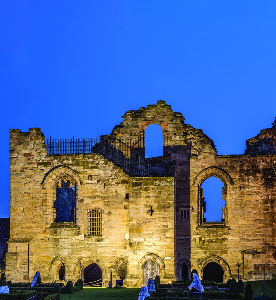
Tutbury Castle has stood guard over the Trent Valley for centuries, especially during the time of unsettled political rivalry that seemed common place until the late seventeenth century. The only way for anyone attempting to attack the fortress had to be along a steep narrow gully rising from the town. To do this was potentially suicidal, not only was it so narrow that it restricted movement to anything more than three or four attackers in line-abreast, but far more important from their point of view, the way passed beneath the castle’s eastern walls, totally without any shelter from missiles raining down from above. There has been a stronghold of one sort or another on this site since at least Neolithic times; during the Viking invasion of northern England it became a winter shelter. The castle we see today was first built by Hugh d’Avranches, to command part of the lands granted to him by William of Normandy as a reward for the knight’s services up to and including the Battle of Hastings. He built a motte and bailey castle on this site – typically a fortified tower overlooking a walled enclosure housing military guards, retainers and domestic animals living cheek by jowl following the castle’s self-supporting design adopted by medieval times. Strangely no wall or tower was built to defend the castle’s western side. Perhaps this was because the grassy slope below that side was considered too steep to be climbed easily by attackers. Tutbury seems to have led a comparatively quiet existence, changing hands only after battles further afield. This was especially so during the Wars of the Roses that took place in other parts of the country. The only hint of violence in Tutbury’ s existence seems to have been a couple of times during the English Civil War when the castle was besieged by Parliamentary troops attacking the Royalists, but even then it appears to have been half-hearted affairs, ending when both sides ran out of food. It was during the rebellious times beginning in twelfth century that Tutbury became a royal castle. In later years it frequently changed hands, with its individual then current owners either repairing the damages caused by weather or accidental fire, or maybe improving the strength of its walls. In 1362 the castle was inherited by John of Gaunt, then the holder of the Duchy of Lancaster, the first of a long line of kings and queens to own it, including our present King Charles lll. Queen Elizabeth ll visited the castle twice during her reign, in 1957 and 1982, culminating the 1957 visit when along with Prince Philip, Duke of Edinburgh, planted two horse chestnut trees that are now fast approaching maturity. MARY QUEEN OF SCOTS IMPRISONMENT AT TUTBURY Following the orders of Queen Elizabeth I, Mary Queen of Scots was held prisoner for nineteen years prior to her execution on the orders of Queen Elizabeth I in the morning of 8th February 1587 at Fotheringay Castle. During the nineteen years of captivity, the Scots Queen had been held on Queen Elizabeth’s orders by the Earl of Shrewsbury, the husband of Bess of Hardwick the intrepid scion of the Cavendish dynasty. During the Scots Queen’s imprisonment, the two ladies became good friends whose mutual skills in embroidery can still be seen at places like Hardwick Hall, or Tutbury Castle. During this time and despite her accommodation being quite comfortable, Queen Mary was moved around properties in the north Midlands owned by the Earl of Shrewsbury. The reason the queen was moved so frequently is that the places where she stayed were singularly lacking in sanitary arrangements and soon became foul stinking places. As a result they had to be left until both nature and man-power had sorted things out. Mary’s lodgings were in a half-timbered cottage below the North Tower. Because of the nature of its design, a half-timbered structure with walls made from dried mud and straw, only the foundation stones remain. EXPLORING THE CASTLE TODAY Entering the castle as it stands at the head of a winding lane from the town, the way into the castle is through John of Gaunt’s Gate. It stands at the northern end of a wide grassy space, called the bailey, an open area with its two attractive, small formal gardens and the remains of two crumbling lookout towers. The more extensive outlines of abandoned buildings appear in the centre of the bailey; these are all that is left of St Peter’s Chapel where, no doubt the doomed queen once prayed for freedom. A line of foundation stones beneath the North Tower and another set closer to John of Gaunt’s Gate are, apart from the slightly more modern buildings lining the castle’s south wall all that is left of this once active fortress. The grassy open space on and around the bailey makes an ideal place for events ranging from civil war re-enactments, costume displays, to weddings, or simply a place where children can play and have adventurous forays around the ruined castle. In the far south west corner of the bailey, a large mound, known as a motte, is crowned with what at first glance looks like a ruined tower. It fits well into the overall ambience of the place, but the tower is, in fact an eighteenth century folly. Following the wall eastwards, the next buildings along it encompass in order of appearance moving away from the motte, the tea rooms, then a house built in the seventeenth century to accommodate the curator. The staircase from here reaches up to the first floor of the King’s Hall, standing high above the semi-ruined spaces of the Great Hall. Beyond this building the outer wall abuts on to the South Tower, the largest part of Tutbury’s defences. LESLEY SMITH – HISTORIAN & CURATOR OF TUTBURY CASTLE AND HISTORICAL PERSONALITIES RE-ENACTOR Lesley Smith, doubles her job as Curator of Tutbury Castle with authentically costumed historical figures, ranging from Queen Boudica to Margaret Thatcher,
The Lost Houses of Derbyshire – Netherthorpe Old Hall

Netherthorpe Old Hall was a stone built Elizabethan small manor house situated in Netherton, one of the group of modest hamlets which surround Staveley – Barrowhill, Mastin Moor, Norbriggs, Poolsbrook and Woodthorpe. Built of coarse ashlar of thin coal measures sandstone, there were hefty quoins and at one time dressings to the doorcases, windows and gables. The roof must once have been of stone slate too, but was latterly of Welsh slate, brought in by rail of the back of the rapid industrialisation of Staveley itself. When new, the house no doubt had a great hall set to one side of the central section, for the bold innovation of a through hall, being introduced by Robert Smythson at Wollaton, Worksop and Hardwick, were still in the future, and without doubt the house will have had all the accoutrements of that of a well-to-do minor gentleman: linenfold wainscotting, ribbed plaster Sheffield School ceilings, and a grand oak staircase. The hearth tax, however, tells us that it was taxed on a modest five hearths in 1670, probably because, with a great hall being the focus of domestic life, there were only four other heated rooms, one of which would have been the kitchen. In the only surviving view of the house, the chimney to the right probably served the great hall and that to the left the kitchen, with the other three sharing one or the other. Generally speaking, it probably looked like an expanded version of Staveley’s Furnace House, a building of similar vintage which ended up in the middle of the giant Staveley Works, surrounded by railway lines and which seems to have literally fallen to pieces around 1906. Yet over the centuries, Netherthorpe Old Hall managed to get modernised, losing its mullioned windows in favour of sashes and later casement openings. There had probably originally been stone copings to the gables with finials, and the great hall was later divided both horizontally and vertically from the seventeenth century to down-grade the accommodation quality in favour of extra space. The history of the place is a trifle complex, but readers of this element of Country Images will evince no surprise at that, one imagines. At Domesday, Staveley was held in chief by a Breton ‘baron’ called Hascoit or Acuit Musard, whose descendants held on there until 1294 when the dynasty ended somewhat chaotically. Ralph Musard who died in 1265 held two knight’s fees in Staveley, and his house was most likely on or near the site of the hall. His grandson John died without issue in 1294, leaving as heir an uncle, Nicholas, who was then rector of Staveley, who had children. At that time, parish priests were still allowed to marry, but that state was one that managed to pass Nicholas by, leaving his children illegitimate, although they were left in his will modest pieces of land locally and one sired the line of de Steynesbys from having acquired land at Stainsby. Therefore, when Nicholas died in 1301, his three sisters inherited the extensive estate in three portions. The eldest, Amicia married Anker de Frecheville, another man of Norman descent, whilst her sister Margaret married John de Hibernia (‘of Ireland’) and the youngest, Isabel, married William de Chellaston. The Frechevilles’ portion included the Musard seat. This three-way split soon reduced to two, though, for the Chellaston marriage left no issue and the Ireland portion, which included Netherthorpe, soon became forfeited to the Crown. In November 1308 as a sort of coronation present, Edward II granted this two thirds of Staveley to Robert de Clifford, 1st Lord Clifford, who was in attendance on the occasion. He immediately settled it, for life only, on the husband of his aunt, Idoine de Vipont, who was John, 1st Lord Cromwell, an old comrade-in-arms of Clifford’s from a campaign in France some years before. The quid pro quo was that Clifford in exchange took a portion of the manor of Appleby, Westmorland, giving him control over the whole Hundred of Appleby. Cromwell probably did not visit his two thirds of Staveley, and it is doubtful if there was at this time any house on it, as all the Musards’ successors had perfectly good houses elsewhere – the Cliffords at Skipton Castle and the Cromwells at Tattershall. On Cromwell’s death in 1335, however, the property reverted to the Cliffords, which family held on to it (presumably granting the manor house to a tenant or bailiff) until John, 9th Lord Clifford was killed in action during the Wars of the Roses fighting on the Lancastrian side in 1461. He was posthumously attainted and his lands once again reverted to the Crown and the estate was again tenanted under the Crown a situation which pertained until 1544. During this time, the Crown’s tenants at Netherthorpe in the later fifteenth century at least, appear to have been called Carter. Indeed, the Christian name of Anker Carter, who surrendered his lease in 1543, suggests that his father John, of Netherthorpe, must have been married to a daughter of one of the Frechevilles, for that family had enthusiastically adopted that distinctive name from their Musard ancestors. Thus in 1543, the new tenant was Robert Sitwell, from nearby Eckington. In 1544, Henry VIII granted the Crown’s two-thirds portion of Staveley to Francis Leake of Sutton Scarsdale, who within a year had sold his unexpected windfall to Sir Peter Frecheville of Staveley Hall, who was keen to re-unite the manorial estate. Needless to say, he also inherited Robert Sitwell, whose lease was almost certainly for ‘three lives’ a medieval system whereby a property could be held until the death of the third person to inherit it from the original grantee, when they could either pay to renew, extend, or merely surrender it. Sitwell was the descendant of a family much more famous now than then, although he was the founder of the family’s fortunes. The family’s origins are obscure. One Walter de Boys, or de Bosco (from French, bois = wood
Derbyshire’s National Heritage Corridor

by Brian Spencer It is wrong to suggest that the Industrial Revolution began in and around the Derwent Valley, but even so the new order was given a massive push forward by the innovations of two mill owners, Richard Arkwright and Jedediah Strutt. They were, as the saying goes, ‘standing on the shoulders of giants’. Even though there is an older mill in Derbyshire, which operated as a silk mill in Derby (now used as the Museum of Making), in 1771, it was Richard Arkwright who built the first cotton mill in Derbyshire. From his previous knowledge of the district, he chose the safety of Cromford, well away from the danger of mobs intent on wrecking his invention that was to change the history of cotton spinning world-wide. In order to fulfil the booming world-wide demand for woven cotton fabrics, it was necessary to develop a speedier method of spinning the raw material brought to England by sailing ships from India and America. As a young man, Arkwright worked as a barber and wig maker in Preston, his hometown. He had a keen eye for anything new or needed by the world around him and he soon realised that so far the only alternative to this laboriously slow method of spinning cotton on a hand and foot operated machine was by a slightly more efficient machine that had been developed by James Hargreaves, a fellow Lancastrian. Called the ‘Spinning Jenny’, but even though it was marginally faster than hand spinning, it didn’t completely answer the problem. The answer came to young Richard Arkwright when he watched iron-workers feed red hot iron into a system of rollers, each one running slightly faster than its neighbour in order to turn iron ingots into workable strips. Arkwright experimented with a system which was based on a smaller and faster version of the machine used by the metal workers. With this he came up with the idea of a system of pairs of vertical rollers, each pair travelling faster than its neighbour. As anyone who has been in a cotton spinning mill knows, the noise of his machine was deafening, giving already suspicious hand spinners the idea that Arkwright was in league with the devil. Moving away from Preston, he opened a mill in Nottingham powered by horses, but he soon realised that he had to think on a much larger scale if he was going to gain the full advantage of his new invention. He needed to run his mill not by horse-power, but by water, giving him a far more satisfactory answer to his problem – which he found near Cromford. From his days as an itinerant barber and wig maker, Richard Arkwright was a regular visitor to the village; here was a plentiful supply of both water and a willing army of workers looking for work as an alternative to the declining lead mines. The mill system he designed for Cromford was built in four stages over twenty years between 1771 and 1791, close to an existing corn mill. Ever fearful of coming under attack from those who spun the yarn by hand, his early mills were more like fortresses than work places. Walk down Mill Road from the A6, and the mill’s walls tower like something out of medieval history – there are no widows along the roadside on what will be level with the ground floor; the only entrance to the mill yard curves inwards to give ever watchful guards the ability to fire their muskets down onto anyone attempting to force the firmly shut gates. Overseeing all movement in and out, the mill manager lived directly opposite, watching the comings and goings of the workforce, especially anyone coming in late, when they would be fined a day’s pay unless they had a genuine excuse. Water was the essential means of driving the mill and at first this was readily available from a pond behind the Greyhound Hotel. It was supplied by Bonsall Brook which flows down the Via Gellia and there was also another source of water power which came from beneath the ground. This was water from a sough which drained lead mines running beneath Cromford Hill. This water could be diverted or held back when necessary by a complex system of culverts filling what the locals call the Bear Pit. Unfortunately this was not very popular with the mining fraternity, because whenever the flow of water from the sough was allowed to build up, especially at times of drought, the result was that flooding occurred further back into the mines. The demand for water increased with the expansion of the number of spinning frames brought into operation. This was supplied by building a weir in the River Derwent behind what became Masson Mill alongside the main road. The extra water supply came from deepening the Derwent as far back as Matlock Bath. The only mill not requiring water power was the subsidiary mill Haarlem Mill at Wirksworth. Being one of the last to be built and away from an easy source of water, it was powered by another innovation – a steam engine. Bringing water power to the mill was not all that was done to alter the appearance of what was originally a tiny village. Being so far from other areas of population, Arkwright decided to build homes for his employees, many of whom, like those in North Street welcomed the upper room. These allowed the male member of the family to follow their profession, as a hand and foot operated stocking frame worker. Arkwright’s sons and grandsons continued to develop Cromford; a school was built at the top of North Street and there was even a cosy lock-up for the occasional criminal. The Greyhound Hotel was built to accommodate the world and his son who came to learn how to train their operatives using spinning frames bought under licence from the by now wealthy and knighted Sir Richard Arkwright. Mills
Lost Houses of Derbyshire – The New Inn Derby
by Maxwell Craven I decided to take a break from country houses this month and mention a licensed house – not that I have run out of the former, but I felt a building as substantial as this merited inclusion, especially as it had a notable place in the history of local coaching and for its connections with the great and good of Derby. As one travels about and, from time to time, calls at inns for refreshment, one is often amazed by the number which style themselves coaching inns without the slightest justification. The coaching inn was, after all, effectively home from home for the well-heeled traveller, aiming to provide the sort of accommodation as a modest country house for the convenience of the inside passengers, extensive stabling for teams of horses, and accommodation for the crews as well. Frequently, the stops en route, rather than overnight ones, were done with enormous speed, such was the competition and tight scheduling on the turnpike roads of the 18th and 19th centuries. Hence, they tended to be spaced at approximately a half-day’s drive between each other on major routes and were mainly in towns and always in the turnpike roads rather than down narrow lanes. One of the last of the celebrated coaching inns in Derby to be built, between 1761 and 1766, was the appropriately named New Inn at the corner of Bridge Gate and King Street and opposite St. Helen’s House. Like the latter, it was probably designed by Joseph Pickford of Derby (1734-1782), although stylistic confirmation is not possible due to a thorough rebuilding some-time after 1873, when a part of it had been lost to street widening and a new façade was put onto the original two and a half storey brick building – and rather awkwardly, to boot, as its cornice stood forward of the roof eaves by a foot. The new King Street front, however, was handsome enough, the window openings almost certainly corresponding to those originally existing, although the sashes were of the upper leaf with glazing bars over plate glass type. Below, the sills were shaped aprons of rubbed brick which, with the playful interplay of string courses, banding and keyblocks, evoked the style of the young Alexander MacPherson (who was a Nottingham man with a busy Derby office) as having been the architect for the alterations. The side elevation was also re-fenestrated at the same time, but within the old openings with their rusticated lintels retained. The inn was built for George Wallis, a relative of Joseph Wright and of the Gells of Hopton; indeed, Sir William Gell is known to have stayed there when in Derby in 1793, on the occasion on which he painted old St Helen’s House from an upper window, giving us a vital record of its appearance seven years prior to its demise. The Wallises were probably the single most important inn-holding family in Derby’s history, and the New Inn remained in their family through three generations and four proprietorships. George Wallis (1694-1780) was the son of a John Wallis, both blacksmiths in King Street, the site of their works – almost opposite the site of the inn – being so occupied until the later 1960s. George’s son, George Wallis I (1731-1786) was a born entrepreneur, and probably had access to the funds he needed through his marriage in 1753 to Rebecca, daughter of John Clarke, a Nottingham Road maltster, whose family ran the Derby Brewery right through the 19th century. George had, though, been apprenticed to his father, becoming a freeman of the Borough in 1754, and initiated a series of stage coach and mail services from his newly founded inn from the start, buying up others’ routes and consolidating his hold both regionally and nationally in a remarkably short period of time. Notable amongst these coaches was the Derby Diligence (‘Dilly’), a service which, amongst others, he later franchised out (to the Bell in this case) simply because the New Inn could not alone cope by the dawn of the following century, with the pressure of all the Wallis services running through Derby. The ‘Dilly’ ran from Derby to Nottingham on Mondays, Wednesdays and Fridays at a fare for inside passengers of 4/- (20p). Wallis also had, by 1773, a mourning coach and hearse for hire and did a roaring trade in funerals and wakes. His sister, Sarah married Dr. Richard Wright, the painter Joseph’s older brother, in 1774 but the absence of any known portrait of a Wallis by the artist seems strange: perhaps they are out there still, but the identity of their sitters has got lost. On George Wallis’s death, he was succeeded by his eldest son William Wallis I (1763-1791). His wife was a cousin of Alderman Samuel Rowland, the co-proprietor of the Derby Mercury, and his elder sister, Sarah married Alderman Dr. Thomas Haden, Richard Wright’s young partner, later father-in-law of Kirk Boott, the founder of Lowell, Massachusetts, USA. Although Wallis died young, like his father, he left three children, of whom the only son, George Wallis II (1788-1834) was too young to succeed him at the New Inn but later married the widowed Mrs. Hoare and through this astute move became also the proprietor of the King’s Head in Corn Market, another much more venerable coaching inn. One of William’s daughters, Sarah, became related by marriage to William Billingsley, the celebrated Derby China painter, and through him to William Wheeldon, another China painter, whilst the other daughter, Anne, married one of Billingsley’s former colleagues, the talented George Robertson. In 1791, therefore, William Wallis’s widow Felicia took the inn over, but was quickly supplanted by her brother-in-law, Alderman John Wallis (1776-1821). He was a prominent Tory, the founder of the Derby True Blue Club (which, inevitably, met at the inn, but later at the King’s Head). He was also the All Saints’ team leader in the Derby Shrovetide football. He, too, ran a tavern, the Black Boy, St.