Derbyshire Villages – Rodsley
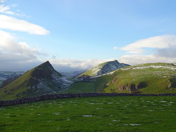
by Maxwell & Carole Craven Having basked in the remoteness and sequestered lanes of Harehill and Muselane, we were much tempted to stay in that wonderfully pastoral and semi-wooded landscape that lies well west of Derby but close to the south western edge of the county. Hence, last August, we ventured between Shirley and Yeaveley in order to re-acquaint ourselves with the delights of Rodsley which Pevsner appears to have forgotten entirely. I suppose that academic 1950s tourist probably got into mental over-load when it came to relatively unremarkable rural brick buildings, but they never cease to delight us and there are gems to be sought. We approached the hamlet from Yeaveley, where we had been doing some research for a privately commissioned history of the Meynells, and travelled east along Rodsley Lane. You should not be misled, however, for almost every road in Rodsley is called Rodsley Lane, for that upon which we were travelling eventually arrives at a cross-roads in the centre of the settlement, from which you can turn left (up Rodsley Lane) to end up in Wyaston, or right, (down Rodsley Lane) which will lead you to Park Lane and eventually to Long Lane, just east of Alkmonton. If you were to go straight across, however, you will actually be entering Shirely Lane which, needless to say, gets you, fairly rapidly, to Shirley. At this juncture a little background might be in order. In 1066, a Saxon freeholder called Brun (Brown in modern parlance) held what subsequently became the manorial estate at Rodsley, although a small portion of the land had earlier been bestowed on the Abbey of Burton as a parcel of the vast manor of Mickleover. Brun clearly failed to survive the Conquest as, in 1086, when Domesday Book was compiled, a Norman called John was holding it, lording it over no less than six villagers and a couple of smallholders. He also had land in Osleston further east. This John appears to be identifiable with (or possibly father of) the John de Turbeville of Rodsley who endowed both the Abbey of Burton and Tutbury Priory with parcels of his land during Henry I’s reign and held a knight’s fee there – that is, enough land to be able to equip and feed a mounted knight (probably himself) for service with the crown. His probable son, another John de Turbeville, died without any surviving children before 1166, when the estate passed to Robert son of William de Alfreton of Alfreton, from whose family it later passed to the Montgomerys of Cubley and thence to the Vernons of Sudbury, who held on to much of the estate until 5th Lord Vernon sold Rodsley to the Cokes of Longford, in which parish the village actually lay. Hence the lords of the manor always had a principal manor house elsewhere, so there was never such a thing in Rodsley, nor consequently, did these lords ever appear to have founded a church. We do not get much of a picture of Rodsley again until the 1664 hearth tax assessment, when we find that every householder – fourteen – in the village had only one (taxable) hearth except Christopher Pegge, who had three but was taxed on only two of them. Christopher Pegge is referred to as ‘Mister’ in the return, and was thus minor local gentry and indeed, was a member of the Pegge family of Yeldersley. Therefore, going towards the village, the first building we encountered was the charmingly named Three Pots Cottage, end-on to the road on the north side. It had been one of Rodsley’s two pubs in the 19th century (and before) – called the Three Pots – although the origin of name seemed to us impenetrable; it certainly was not heraldic, which was my first thought. It was run by a William Mansfield in 1827, but soon passed to the Ratcliff family, who obviously also had worries about the name for, between 1835 and 1846, they re-named it the New Inn, although it had reverted to the Three Pots by 1857, only to become the New Inn again by 1864 but, by the end of the century, it was calling itself the Old Three Pots. It seems not to have survived the first decade of the 20th century, however and was gone by 1908. As the delightful twin range 18th century brick cottage lies a good way outside the village centre and near nowhere in particular, I cannot say we were surprised! Three quarters of a mile further on and one once again encounters some buildings, part of the appropriately named Corner Farm, the entrance of which is set on the NW angle of the cross roads, which here manifests itself. As we approached the crossroads, we saw a long low brick barn on our left, to which is affixed, near its east end, a cast iron plaque erected by the Sherwin Society in 1976 to mark the canonisation of locally-born Catholic martyr, St. Ralph Sherwin in 1970. Ralph Sherwin was born in 1550, younger son of John Sherwin of Rodsley, farmer, and was educated at Eton as a scholar from 1563, which establishes that John Sherwin was no mere peasant farmer. His wife’s brother was John Woodward, rector of Ingatestone, Essex, who was the appointee of local grandee Sir William Petre and the latter clearly helped Ralph to obtain a fellowship at Exeter College, Oxford, after which he converted, went to Douai, was ordained and then on to Rome, after which he was one of a group of young missionary priests sent to re-evangelise England, but was arrested tried and executed in December 1580. His ministry had lasted hardly six months. We were by no means clear which of the farms clustered round the crossroads had been that worked by John Sherwin, but certainly the family was still in the village in 1666, when the saint’s great-nephew, another John died, leaving the poor of the parish £1 yearly out of
Places Pevsner Forgot – Hardstoft & Astwith

Hardstoft and Astwith lie atop a pair of west-east ridges, with the Dawley stream rising in between and running down to the Doe Lea, above which towers Hardwick old and new halls, which visually dominate both hamlets from the east. We first made the acquaintance of Hardstoft around 1980, when, with my colleague Mick Stanley and his wife, we were moving about the county looking at the country houses whilst preparing the first edition of The Derbyshire Country House. After visiting Newton Old Hall at Tibshelf, we headed north but needing lunch, stopped at the Shoulder of Mutton, Hardstoft, which lies at the end of a row of 18th century cottages on Deep Lane, leading off the B6039 towards the heart of the hamlet. Then, the pub was a fairly run-of-the mill local one, and if Pevsner saw it in 1951 he perhaps did not require a pint and a sandwich and pushed on in blissful ignorance of the delights of the invisible settlement, in which case he missed a treat, albeit a gentle, unassuming, one. Yet it is not without interest, as there are two listed buildings in Hardstoft and one in the adjacent but far more sequestered hamlet of Astwith. The name commemorates one of those Norse settlers of the ninth century whose name is found nowhere else in the annals of the English Danelaw for it means ‘Hjǫrtr’s farmstead’, in contrast to Astwith, which is also a Norse derived name but means merely ‘east clearing’. Both are part of the parish and manor of Ault Hucknall, held by Steinulf of Calow under Norman grandee Roger de Poitou in Domesday Book (1086) and, from the 16th century, if not before, were long part of the Hardwick Hall estate. Indeed, when the late Duke of Devonshire gave Hardwick to the National Trust in 1950, the Chatsworth estate quite probably retained the working part of the estate, less whatever the Trust required as an endowment. So much for history: we started at the pub which, we were amused to see, had dumbed down its name to The Shoulder, which, let’s face it, sounds more like a painting by Salvador Dali – odd, even in the context of pub names. It is the end element of a row of three 18th century double fronted estate cottages built, like most houses in the two hamlets, of Coal Measures Sandstone, but with most engaging paired chimneystacks with chamfered angles in 18th century brick – no doubt a conceit of the Hardwick estate foreman of the time. We were able to trace the inn back to the 1820s, but it may well have flourished before that. From the early 19th century until the First World War, it was run by the Clay family, several of which were called Sampson; after the war the Tagg family took over for a couple of decades at least. Nevertheless, it was pleasant within and welcoming, and our modest requirements were met with creditable aplomb. We then set off along Deep Lane, which runs from the main road towards the heart of the settlement but turned off right along Farm Lane, a tributary running off it, parallel to the main road and behind the inn with its attendant buildings. At its south end this afforded excellent views south to Biggin Lane and over a declivity in which stood a white painted former farmhouse called Whitton Lodge, about which we were able to discover little other than it is now a roomy holiday let. It boasted a good cartshed or barn, now converted. A much more unspoilt seventeenth century farmhouse lay on the east side of the lane with Hardwick Old Hall across the valley seeming almost within touching distance. The fenestration had been modernised, but otherwise it was charming and largely original; how it escaped listing we couldn’t work out. Further east, on Deep Lane, The Green presented us with a group of engaging stone houses and farms with a neat row of cottages bookended between two of them. Slightly north, was The Yews (alternatively Yew Tree Farm), another farmhouse, one of Hardstoft’s listed buildings, under restoration and empty when we saw it. Historic England reckons it’s mid-18th century, but we reckoned that, with its paired mullioned lights and elegant simplicity it could be late 17th century with an extension to the east. It was probably amongst the buildings on The Green that much of the working life of the hamlet took place, for in 1827 one William Haslam is listed as a gunsmith there and a succession of William Halsams continued the tradition of white-smithing into the 20th century and latterly as ‘hot water engineers.’ Indeed, George Haslam was still pursuing this trade in 1928. There was also a shoe and boot maker, estate gamekeeper and, on the main road further north, the New Inn (a beerhouse long closed) and a school. One of the most notable craftsmen to have graced Hardstoft was Joseph Kirk (1681-1735) who made exceptionally fine clocks, including one at Hardwick and another in a chinoiserie lacquered case. He seems at first to have been based here, but later signed clocks from Nottingham (eg. that in Derby Museum’s Prince Charlie Room) and latterly from Skegby, where his London-trained father, John, had also lived latterly, where he died. A Kirk clock made in Skegby was sold from Chatsworth a decade or so ago, and he also made the stable clock there which survived to be transferred into James Paine’s new, bravura, structure in the 1750s. The old directories mention that the Wesleyan Methodists once had a chapel here, although we couldn’t work out which building it had occupied, but the school, founded as a Church of England School in 1858 (and so dated) lies on the main road between Deep Lane and Astwith Lane. Built of hand-made brick and stone dressings, it has a steep gabled portico with the date, and a bell turret. This pretty little building with its iron railing, long derelict,
Derbyshire’s National Heritage Corridor

by Brian Spencer It is wrong to suggest that the Industrial Revolution began in and around the Derwent Valley, but even so the new order was given a massive push forward by the innovations of two mill owners, Richard Arkwright and Jedediah Strutt. They were, as the saying goes, ‘standing on the shoulders of giants’. Even though there is an older mill in Derbyshire, which operated as a silk mill in Derby (now used as the Museum of Making), in 1771, it was Richard Arkwright who built the first cotton mill in Derbyshire. From his previous knowledge of the district, he chose the safety of Cromford, well away from the danger of mobs intent on wrecking his invention that was to change the history of cotton spinning world-wide. In order to fulfil the booming world-wide demand for woven cotton fabrics, it was necessary to develop a speedier method of spinning the raw material brought to England by sailing ships from India and America. As a young man, Arkwright worked as a barber and wig maker in Preston, his hometown. He had a keen eye for anything new or needed by the world around him and he soon realised that so far the only alternative to this laboriously slow method of spinning cotton on a hand and foot operated machine was by a slightly more efficient machine that had been developed by James Hargreaves, a fellow Lancastrian. Called the ‘Spinning Jenny’, but even though it was marginally faster than hand spinning, it didn’t completely answer the problem. The answer came to young Richard Arkwright when he watched iron-workers feed red hot iron into a system of rollers, each one running slightly faster than its neighbour in order to turn iron ingots into workable strips. Arkwright experimented with a system which was based on a smaller and faster version of the machine used by the metal workers. With this he came up with the idea of a system of pairs of vertical rollers, each pair travelling faster than its neighbour. As anyone who has been in a cotton spinning mill knows, the noise of his machine was deafening, giving already suspicious hand spinners the idea that Arkwright was in league with the devil. Moving away from Preston, he opened a mill in Nottingham powered by horses, but he soon realised that he had to think on a much larger scale if he was going to gain the full advantage of his new invention. He needed to run his mill not by horse-power, but by water, giving him a far more satisfactory answer to his problem – which he found near Cromford. From his days as an itinerant barber and wig maker, Richard Arkwright was a regular visitor to the village; here was a plentiful supply of both water and a willing army of workers looking for work as an alternative to the declining lead mines. The mill system he designed for Cromford was built in four stages over twenty years between 1771 and 1791, close to an existing corn mill. Ever fearful of coming under attack from those who spun the yarn by hand, his early mills were more like fortresses than work places. Walk down Mill Road from the A6, and the mill’s walls tower like something out of medieval history – there are no widows along the roadside on what will be level with the ground floor; the only entrance to the mill yard curves inwards to give ever watchful guards the ability to fire their muskets down onto anyone attempting to force the firmly shut gates. Overseeing all movement in and out, the mill manager lived directly opposite, watching the comings and goings of the workforce, especially anyone coming in late, when they would be fined a day’s pay unless they had a genuine excuse. Water was the essential means of driving the mill and at first this was readily available from a pond behind the Greyhound Hotel. It was supplied by Bonsall Brook which flows down the Via Gellia and there was also another source of water power which came from beneath the ground. This was water from a sough which drained lead mines running beneath Cromford Hill. This water could be diverted or held back when necessary by a complex system of culverts filling what the locals call the Bear Pit. Unfortunately this was not very popular with the mining fraternity, because whenever the flow of water from the sough was allowed to build up, especially at times of drought, the result was that flooding occurred further back into the mines. The demand for water increased with the expansion of the number of spinning frames brought into operation. This was supplied by building a weir in the River Derwent behind what became Masson Mill alongside the main road. The extra water supply came from deepening the Derwent as far back as Matlock Bath. The only mill not requiring water power was the subsidiary mill Haarlem Mill at Wirksworth. Being one of the last to be built and away from an easy source of water, it was powered by another innovation – a steam engine. Bringing water power to the mill was not all that was done to alter the appearance of what was originally a tiny village. Being so far from other areas of population, Arkwright decided to build homes for his employees, many of whom, like those in North Street welcomed the upper room. These allowed the male member of the family to follow their profession, as a hand and foot operated stocking frame worker. Arkwright’s sons and grandsons continued to develop Cromford; a school was built at the top of North Street and there was even a cosy lock-up for the occasional criminal. The Greyhound Hotel was built to accommodate the world and his son who came to learn how to train their operatives using spinning frames bought under licence from the by now wealthy and knighted Sir Richard Arkwright. Mills
Places Pevsner Forgot by Maxwell & Carole Craven
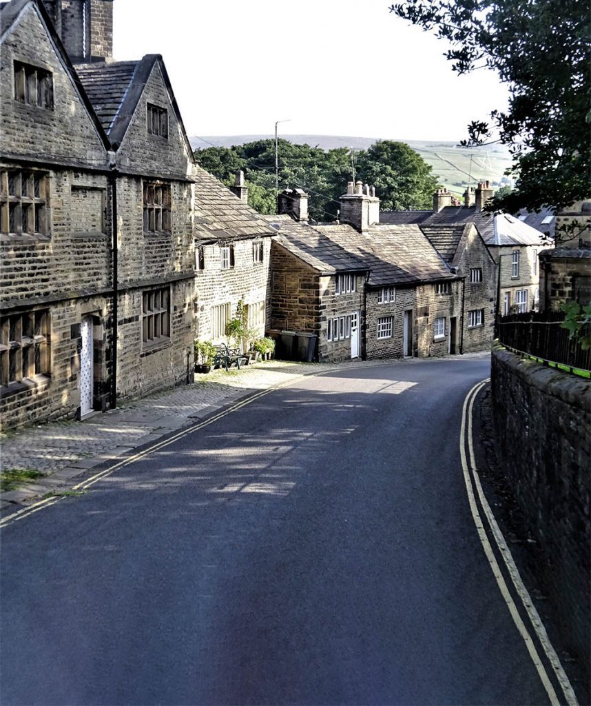
We supposed that Sir Nikolaus Pevsner missed Horsley Woodhouse because he probably travelled north along the Derby to Heanor road, and was thus able to enjoy Smalley, and on another occasion doubtless journeyed south west from Denby towards Coxbench (neither of which he missed) passing by Horsley Woodhouse at Four Lane Ends where that road crosses the Smalley to Kilburn Road (A609), upon which, straggling along a ridge, Horsley Woodhouse lies. Indeed, the ridge is relatively high and gives a superb view north towards Denby and indeed Ripley, and a less spectacular but more charming one into the shallow valley of Gipsy Brook running parallel to the south, in a vale called locally Golden Valley. One hundred and fifty years or so ago, it would have looked a lot different however, for Horsley Woodhouse was then a small mining settlement, coal mines, many of them adits, driven horizontally into the hillside rather than vertically downwards. Indeed, coal extraction probably accounts for the original settlement, first recorded as Wudehus in a fine of 1225 and as Horselewodehus in the patent roll for 1303. ‘Woodhouse’, essentially means the ‘house in a wood belonging to [the manor of] Horsley’ in which parish it lay until 1878. This house was probably later the residence of William de Stainsby, who settled there by inheritance at the east end of Golden Valley in around 1328. His house later became Stainsby House, the occupants of which, latterly the Wilmot-Sitwells, were local coal owners until the first part of the twentieth century. Indeed, the coat-of-arms of their predecessors the Fletchers, were adorned with miner’s dials, to advertise the source of their rise in status into the landed gentry! Driving along Main Street, one might be forgiven for dismissing the place as a rather dreary collection of 19th century miners’ cottages. Whilst this is to some extent true, there is much to enjoy in them and more so scattered amongst them. It is not easy to find a safe place to park, so we chose the car park of the Old Oak, situated about half way along on the north side, a pleasant stuccoed early 19th century building built in two phases, and recorded as a pub only from the later 19th century. Being reasonably responsible people, we called to refresh ourselves and asked the landlord if he would mind if we had a wander before returning for the car, to which he raised no objection; after all, it was a quiet day in mid-January. Thus fortified, we turned west, toward Four Lane Ends. Noting the stunning views to the north from a lane beside the pub. Here the houses gradually become early twentieth century although there are a few older ones, including an oddity, No. 121 (south side) a Victorian three bay villa turned into a bungalow with its first floor removed (perhaps after a fire?) but still displaying Flemish bond brickwork and a fine stone front doorcase. The semi-detached former council houses on the north side are well designed and matured well. The only interesting aspect of the village here is the Roman Road, Rynkneild Street, about the course of which we wrote in Country Images some years ago. This runs north-south here and is marked by a hedgerow to the north, but from the road only by the oddly off-line western boundary of No. 216. To the south, a track called Golden Valley (worth exploring if only for the glorious countryside) runs off parallel but it is otherwise not readily apparent, although also parallel to it to the west is a once fine terrace of cottages called Horestan Place, much marred by later alterations and ‘improvements’ but probably a lot easier to live in for all that. Returning eastwards, past the very useful Co-op, back past the pub, we noted No, 94 (south side), another cut-down former three storey dwelling, probably of around 1790 with posh lintels and keyblocks but again, reduced by a storey and even then, the surviving first floor has been further diminished in height. It suggested to us that the emphasis of the village economy had changed from a preponderance of agriculture and framework knitting to an increased mining population from c. 1800, causing houses to be reduced and in one or two instances subdivided into smaller cottages. Yet the age of this house did suggest that we were entering the original core of the village and immediately, on both sides the cottages are terraced with doors opening onto the street. Just beyond these on the left is a pretty impressive Arts-and-Craft house, 1920s rather than Edwardian, representing another of the settlement’s pubs, this time, long closed. This began as a beerhouse, the Knife & Steel, in the 19th century, but this ambitious rebuilding must have marked an attempt to go up-market – but to no avail, for it had closed for ever by the outbreak of war, to be converted into two houses called – inevitably Knife and Steel. Just beyond, we found Fairfield Road running downhill to the north, a chance to discover what delights might lie behind the main drag. We were not disappointed, for beyond further mid-19th century and later miners’ cottages and a post-war estate, we encountered The Crescent. Situated at virtually the lowest point we found what is surely the oldest surviving building in ‘’Ossly Woodus’: a stone-built cottage with much altered fenestration – amazingly un-listed. This was built, presumably in the 17th century (or earlier) and was for many years the Old Knife and Steel, prior to being re-named the New Inn, when its name migrated to the pub on Main Street. The building is dated 1672 on a chimneypiece, the front door and upper windows have been neatly blocked and an extension added: a very attractive ensemble, again with wonderful views from the rear. Further along Main Street, a plethora of new walling and gate-piers marks Willow Grove, an early Victorian villa recently rebuilt almost out of recognition, but the local doctor’s
Places Pevsner Forgot – Makeney, Derbyshire
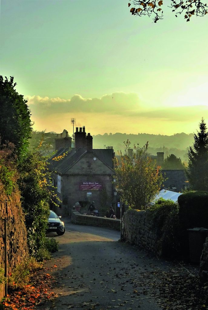
As we wandered round sunny Makeney, we wondered how Pevsner could ever have forgotten to include the place, for although historically a miniscule hamlet within the huge parish of Duffield, it gained in importance in the 19th century through its proximity to the various expanding Strutt family enterprises at Milford and gained two important houses as a result, although there never was either church or chapel. Furthermore, there is an historic inn, the Holly Bush, probably of 17th century origin with an historic turnpike trust way-marker set against its wall. How could he possibly have missed it, we wondered, especially as the hamlet is clearly visible from the A6 going north. No matter, however, we were on hand to make our own assessment. The village is situated on the east side of the Derwent on the unclassified (but remarkably busy) former turnpike road from Duffield church, along Duffield Bank to Milford, which originally ran past the pub and down the other side, but which acquired a new section cutting off this loop, now Holly Bush Lane, pitched around 1870. Holly Bush Lane also has a steep lane leading off from its apex called Dark Lane. We decided to park well clear of the Holly Bush, the narrow road outside which tends to clog up with parked Chelsea tractors, instead leaving the state chariot parked on the road near Red Lane, which winds up from a point just south of the village to Holbrook. This enabled us to see a very smart Regency cottage orné by the junction called Makeney Lodge, still with its original cast iron sliding jalousies at the windows, an adjunct to refined living famously made in Derby at Weatherhead, Glover & Co.’s Britannia foundry, Duke Street. The interior is very fine, and is illustrated in Bobby Innes-Smith’s 1972 Derbyshire Life book on local houses, from which we may infer that the cranked-out stair balustrade was also sourced from the Duke Street foundry. This should occasion no surprise, as the house in its current form was built around 1825 for Anthony Strutt (1791-1875), and probably designed by his uncle, William Strutt FRS, a keen amateur architect. It also incorporates a datestone bearing the legend HP/1784 which are apparently the initials of Henry Peat, who is believed to have rebuilt an earlier farm house there, dating from c. 1730. This may be true, for a Henry Peat married Elizabeth Beardall at Duffield in 1730, and a son may have effected a rebuild. Either way, there is no visual evidence in the existing fabric that the house you see today is anything but a new build. Why it escaped being added to the statutory list defied us; perhaps in 1981 when the County was re-listed they failed to drive along on that side of the Derwent! By 1846, Strutt had moved up Dark Lane to another new house, confusingly named the Old Hall, and sold the Lodge to Maj. Alfred Holmes (1816-1895) son of Charles, of the famous Derby coach building company. His heirs sold it to Judge Henry Raikes, chairman of Derbyshire quarter Sessions, and his family sold it to the Heyworths in 1954, connections by marriage of our own family. It has changed hands again since, most recently in 2015. Strutt was a restless fellow, however and he acquired yet a third large house in the hamlet. This we never saw as we wandered along past Hollybush Lane, because it failed to survive, its site being taken over by the stable block (now converted as residences and a business) built by George Herbert Strutt, Anthony’s great-nephew, when Makeney House was built. We reached this point by walking along the main road, past an elevated row of eight artisans’ cottages under a continuous roof built by Anthony Strutt for the Milford Mill workers in the 1820s and called Makeney Terrace. These, although a little altered, are listed grade II. Beyond them is a real gem: the original Makeney Hall, later Old Hall farm. Built by Richard Fletcher around 1814, and later sold to a branch of the Bradshaws of Duffield. The old guides claim that Judge John Bradshaw, a regicide in 1649 was born there, but in fact he was a Cheshire Bradshaw with no connection here. It was later acquired by the Heath family, which in the 18th century produced three brothers who founded a bank in Derby (which went bust in 1779). They turned it into a farm, sold it back to the Bradshaws, from whom it passed to Charles Mould who built the house Anthony Strutt acquired, and remained a farm until the mid-twentieth century, when it was divided into four tenements under the name Makeney Yard (deservedly listed grade II). It is a stone gabled building of considerable charm, but the frontage of which is rather marred by the parked cars of the four occupying families. It was immediately north of that where the converted stables are positioned. The house (called the Hall) was built in 1813 on his marriage, possibly by adapting a wing of the old hall, by local iron founder Charles Mould on land bought from the Bradshaws. However, in 1856, a sale was agreed between Mould and Anthony Strutt of both house and estate, most of which lay on the water meadows to the west of the road. In a letter of 10th March 1869, Strutt wrote to a friend, “I found it [Mould’s house] a strange mixture of some modern additions and ornaments made when the young Charles Mould got married, very absurd indeed, [but the] main stone work of old building very good.” He goes on to say that he had begun work to ‘make the house habitable’ but by 1869, had lost heart and offered the place to let. The rebuilding works, which were begun in 1858, were probably overseen by the Derby-born architect of Buckingham Palace, Edward Blore (1787-1879), who had recently built Kingston Hall (Notts.) for Strutt’s nephew, Edward, recently elevated to the peerage
Glossop & Old Glossop
Like Hope, Hathersage and Chapel-en-le-Frith, Glossop was once a vast parish of over 50,000 acres, subsequently subdivided, covering the hills of the western Dark Peak. In 1086 it was part of an even larger entity, the lordship of Longendale, held directly by the king, and it remained as such except for a brief period under Henry I when it was granted to William Peveril. After the Anarchy however, Henry II gave it to the Cistercian Abbey of Basingwerk, Flints (now Clwyd) and they held it until the Dissolution. As a result, Henry VIII granted it to Francis Talbot, 5th Earl of Shrewsbury and it remained largely with his descendants, the Talbots and the FitzAlan-Howards, Dukes of Norfolk, until the twentieth century. Old Glossop sits on a south facing hillside, and originated in the medieval period. The modern town, initially Howard Town, later New Glossop and now just Glossop, was created around cotton mills in the early 19th century through the encouragement of the FitzAlan-Howards (whose coat-of-arms can be seen all over the place) and lies further down, occupying the valley. The name, according to modern reference books, derives from the Anglo-Saxon hop(e) (= valley), suffixed to the notional Saxon name of ‘Glott’ (in the genitive, hence an additional ‘s’), thus ‘Glott’s valley’. However, these references invariably prefix the name with an asterisk, which means it has been deduced by academics from the name’s earliest forms but is unattested by any known personage bearing it. Bearing in mind that the area probably remained under British control until near the end of the seventh century, one might propose a British origin for the first element, like Glôg (= a rock or knoll, appropriate enough hereabouts) or the well- attested British personal name Glywys, with the Saxon suffix added. Such hybrid place names are not uncommon, especially in the North and West and more are being admitted as research is re-defined. Such arcana did not affect our visit on a blazing hot day. Old Glossop is a total delight, and once was centered on the hall, latterly a vast, rather unlovely mansion, demolished by the Council in 1959 (see Country Images May 2018). This lay quite close to the church of All Saints, with a fine park rolling down the hillside. The church itself is an ancient one, and quite substantial, but has suffered numerous rebuildings – no less than five since the beginning of the 19th century, leaving little of the original 12th century church. We actually began beside the stump of the medieval churchyard cross, rather neglected looking, on the south side, by walking up from the church past the former church primary school of 1854 by Matthew Ellison Hadfield (1812-1885), a Glossop man, son of the Dukes’ local agent, Joseph, who, through the patronage of the Howards rose to eminence as an architect here and then in Sheffield as Weightman & Hadfield. He designed much of the new town of Glossop. The school is remarkably substantial, and was converted into several spacious houses three years ago, winning an award. We pressed on past up to the upper road, Church Lane continuing NW until we reached ‘the opposition,’ as one elderly local called it, the splendid late Regency Catholic church (also dedicated to All Saints) by M. E. Hadfield of 1836, although it looks almost earlier, with its neat classical villa of a presbytery beside it. It was the private chapel of the (staunchly) Catholic Dukes of Norfolk until 1925, despite the hall also having had an attached chapel. We then pressed on along Church Terrace until we reached the main (Woodhead) road, where we turned left down the hill into Glossop proper. Woodhead Road morphs into Norfolk Street, and for half a mile one passes through a leafy suburb with houses either side ranging from late Victorian to inter-war. Further down, things change: opposite the corner of Kent Road is a pair of stone built houses, very pretty, in an unexpected cottage orné style, followed by a substantial mid-Victorian terrace, with further terraces beyond on both sides. This continues for another country half-mile until suddenly the descent steepens and the road widens. On the right is the very striking Manchester, Sheffield & Lincolnshire Railway’s classical station of 1847 (by the omnipresent Hadfield, naturellement). The noble lion crest of the Howards atop the parapet attests to the fact that the 13th Duke personally paid for the one mile branch line from Dinting that terminates at the rather grand station itself. The line (later the Great Central, then 1923-1948, the LNER) is today still operating and long electrified. Opposite the station a very tall sub-Jacobean Conservative club of 1909 with a first floor angle gallery upheld by a stumpy fat column with stiff leaf capital. Further down, on the corner of High Street, we found the early Victorian Norfolk Arms Hotel, very welcoming, where we paused for much needed sustenance. This, essentially, is the grandly planned centre of Howard Town, later (New) Glossop. We proceeded along Henry Street to Norfolk Square behind the pub, where Tesco have tactfully adapted the station’s good shed, and passed, on our right, an Italianate building, now shops, and a hidden Masonic Hall, its modest entrance amidst a stone residential terrace looking almost furtive in its discretion but, from the notices advertising the availability of a large hall for weddings, funerals and bah-mitzvahs (as it were), we deduced that behind lay an edifice of noble proportions, invisible to us. Opposite lay sloping Norfolk Square itself bosky and with elegant buildings in the usual honey-coloured Dark Peak millstone grit on all sides. The NE corner is host to a tall Jacobean Liberal Club of 1914 by Paul Ogden, with blue plaque honouring Hon. Mrs. Mary Partington MBE a philanthropic ex-Mayor of the town and daughter-in-law of the largest employer in the Borough, Edward, 1st Lord Doverdale). Beside it is a splendidly Belle Epoque war memorial in bronze with winged victory (by Vernon March of Hadfield’s old practice)