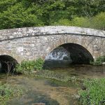
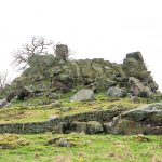
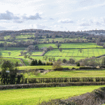
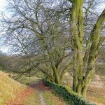
Edit Template

Walks In Derbyshire

There really is no better way to see the beautiful area that we live in than to walk in Derbyshire. Over the years we have walked what feels like pretty much the entire of Derbyshire and Nottinghamshire and feel it only right to share those walks with you. In every edition of Country Images Magazine we feature a walk for you to follow and now we’ve put them online for you to read too. If you have a mobile or tablet, why not follow the walks on it, with a map and an explanation of where to go it’s ideal for you to follow so as not to get lost. We hope  you enjoy the selection below and check back regularly for new walks.

 
  • All Posts
  • Walks
Walk Derbyshire – A Winter Warmer Around the Longshaw Estate

November 26, 2018

I have to make an apology before embarking on the text for this walk.  In July I acquired a new hip, this was after upwards of ten years trying to ignore an ever growing problem. Fortunately I had the sense to build up a stock-pile of walks, which kept Garry and Alistair happy at Images HQ, making it possible for them to publish my walks as and when necessary. Feeling a lot better since my session with Mr Williams, one of the osteopath surgeons on the staff at Calow Hospital where, I must add, I didn’t feel a thing, and was much entertained by what sounded like the opening bars of Giuseppe Verdi’s Anvil Chorus from his opera il Travatore! Deciding it was time to put my boots on again, I chose this walk mainly because it is short and finishes with the alternative of a pub lunch or the excellent soup and sandwiches on offer at the National Trust tea-room next to Longshaw Lodge.  Using easy to follow paths through what was once a sporting estate, the walk drops down into the upper valley of Burbage Brook.  Here it joins one of the ancient Pack-horse tracks that once linked Sheffield to the salt wells of Cheshire, and carried finished metal goods such as scythes on the return trip. With far reaching views throughout, the walk starts by skirting the front of the lodge, along a path between it and the open moors now grazed by sheep, but once the realm of sportsmen and their guns in search of game. Going through a swing gate, the path splits with one going south towards Big Moor, and the other bearing right, drops down to the Grindleford road.  This is the one we took, going past an attractive pond, the haunt of...

Walk Derbyshire – A walk around Ilam Hall

September 25, 2018

Tucked away on a bend of the Manifold river, Ilam Hall village was built in the 1820s on the instructions of Jesse Watts-Russell. The original Victorian houses of the village echo the fairy-tale image of the hall, built at a time when skilled labour was cheap. It was also a time when tenants could be moved at the whim of their landlords if, as in this case, he wanted more space or privacy. The Ilam Hall we see today, with its Tudor-style chimneys and mock Gothic architecture, is only part of the original building; the central tower and most of the formal rooms were demolished in the 1930s. The rest of the building was due to suffer the same fate when it was bought by Sir Robert McDougall, a Manchester businessman. He had the remaining parts of the hall made habitable and presented it, together with the grounds, to the National Trust, instructing that the hall be used as a youth hostel. Hall and village replaced dwellings of a much earlier vintage, whose history can be traced back to Saxon times. St Bertram, an early Christian missionary, hid himself in a cell near where the river bubbles to the surface below the hall. By his pious example, he persuaded the locals to abandon their pagan beliefs. It is possible he preached at the foot of the rough cross which now stands by his church. Carving on the cross is Viking, dating from around AD900-1000. The church was ‘improved’ by Watts-Russell and its original 17th – century lines are broken by an octagonal mausoleum. The shaft of another stone cross, known as the Battle Cross, was found in the foundations of a cottage during the rebuilding of the village. It now stands to one side of the riverside walk and is...

Walk Derbyshire – Around Winster

July 24, 2018

Winster is a haphazard cluster of seventeenth and eighteenth- century houses linked by narrow hillside alleys or ginnels as they are known locally.  They sit in a pattern which suited the lead miners and their families in the hey-day of this now extinguished Peak District industry. The walk follows paths once trodden by miners who, usually in small groups, delved beneath the surrounding heights.  Often run on a part-time basis, the miners would be satisfied with a daily input of enough ore to fill their wes’kit (waistcoat) pockets.  Small abandoned stone barns, used as stores by these miners, still dot the surrounding fields.  At the side of the nearby B5056 Cromford/Bakewell road, close to its junction with the Newhaven road, a communal lead store has been preserved as an interpretive feature.  A little way down the road from it, the Miners’ Standard pub takes its name from the standard dish used to measure quantities of ore. In contrast with this small-time mining activity, the last and most productive lead mine in Derbyshire was nearby at Mill Close.  It was still in operation until 1939 when flooding led to its abandonment. The central feature of Winster is a two-storied, late seventeenth-century Market Hall.  Standing opposite the co-operatively run village store and post office, it was the first National Trust property in Derbyshire.  Winster has its own team of Morris Dancers, and every Shrovetide the women and children of the village hold pancake races along the main street. Parking is difficult in the centre of Winster, but can usually be found roadside to the west (Elton) side of the church, or at a dedicated car park above the village near the Miners’ Standard.  The Matlock to Bakewell via Elton bus runs through Winster (but not on a Sunday). The Walk : Walk...

Derbyshire Walk – Elvaston Castle

June 27, 2018

This walk, around the parkland of Elvaston Castle, is one of my occasional excursions from some of Derbyshire’s grand houses.  Unfortunately it could almost be described as from one of Maxwell Craven’s ‘Lost Houses’.  Financial constraints on its present owners, Derbyshire County Council, make it impossible to fund the necessary £6.1 million needed to restore the building’s fabric; something that has put it very firmly on the list of ‘Buildings at Risk’ register.  As a result of the house being unsafe, it means that it has been closed to the public since 2008, but the 200 acres of parkland around which this walk goes, are still freely accessible. There is also a programme of events in the park throughout the year, ranging from an Easter egg trail, to a night time guided nature walk – for further details check www.derbyshire.gov.uk/countryside events. Until Henry VIII’s Dissolution of the Monasteries, the estate was owned by Shelford Priory, after which it was sold in 1538, to Sir Michael Stanhope of Rampton, Notts.  Following his death in 1611, the whole estate, including Elvaston, was inherited by his second son, also called Michael.  He became High Sheriff of Derbyshire and died in 1638, but not before he built the Elizabethan-styled house at Elvaston on the outskirts of Derby in 1633. With little change, Elvaston passed steadily through generations of Stanhopes until the 19th century.  This was when Charles Stanhope, 3rd Earl of Harrington employed the architect James Wyatt to extend and re-develop the castle in the then popular Gothic Revival style. During this time a new wing and the great hall were added.  Further modifications on the Elizabethan-styled south front were carried out in 1836 by the architect Lewis Nockalls Cottingham, leaving the building very much as we see it today. Vacated by its original...

Walk Derbyshire – Foolow & Silly Dale

June 5, 2018

There are no records of any simpleton, either in Foolow or Silly Dale; both names come from Anglo Saxon English and have entirely different meanings than in today’s language.  Foolow means multi-coloured hill, possibly a reference to nearby Eyam Edge. Silly is Old English for pretty, an apt description of this little-known dale, especially in late spring when the limestone-loving flowers are in full bloom. The walk starts and finishes in Foolow, a village of light grey limestone cottages, arguably the most picturesque in the Peak District National Park.  There is a bay-windowed manor house and the Bull’s Head offers an excellent menu to satisfy the hunger of the hardiest walker.  Until 1888 when the tiny limestone church dedicated to St Hugh was opened, church-goers congregated around the ancient stone cross and its pagan bull-ring standing next to the duck pond. Until 1932 when pipes were laid, water was a problem in this upland village.  Before then villagers had to collect water from a well a little way along the Hucklow Edge road above the village.  Cattle enjoyed the convenience of the attractive duck pond on the village green and in celebration of the gift of water, village wells have been dressed since 1983 on the Saturday prior to the last Sunday in August. Starting from Foolow the walk climbs up to Hucklow Edge before turning west and descending to the neighbouring village of Great Hucklow.  This village, clustered around its pub, the Queen Anne, is really a group of five inter-linked hamlets where lead miners delving 600 feet beneath the ground, worked the riches of High Rake, following a series of inter-connected veins running north-westwards.  Pack Horse teams once carried the ore together with Cheshire salt across the high limestone moorland, by trackways that can still be traced for...

Walk Derbyshire – Tideswell, Miller’s Dale and Litton

May 1, 2018

The history of the Peak District is writ large on this walk.  Starting way back in time when volcanoes spewed out their lavas, the walk enters one of the loveliest dales in the White Peak, but it was where orphaned children were unable to enjoy its delights.  Climbing out of the dale, the way is across fields whose layout would still be recognised by the medieval farmers who ploughed their furrows with pairs of oxen.  Two villages come next, Litton and Tideswell, the latter with its church classed as the ‘Cathedral of the Peak’.  From there the way back to the car park follows back roads and footpaths laid out well over a hundred years ago. The volcanic activity mentioned above took place in what is now known as Tideswell Dale.  The hillside to your left, on walking down the dale, has some quarried areas of dark coloured rock between layers of limestone. These are the remains of lava flows that spewed out of volcanic vents surrounding a tropical lagoon that once covered what became the White Peak of Derbyshire.  At the dale end the path joins the main, or Miller’s Dale down which flows the clear waters of the Derbyshire River Wye.  A mile or two downstream the river enters its prettiest section, aptly called ‘Water-cum-Jolly Dale’, but before it reaches this sylvan glade, the river once powered a cotton mill whose young operatives lived a life of hell.  This is Litton Mill to which orphaned children were brought from workhouses as far away as London to enter a life of cruel servitude as so-called apprentices.  Nowadays the mill having ceased production, has been converted into apartments and its subordinate cottages are now lived in by locals whose ancestors may well have been those orphans apprenticed to slavery. There...

Load More

End of Content.

We hope you enjoy the walks, but check back regularly for more walks in Derbyshire and walks in The Peak District as we are constantly adding new ones.

Country Images Magazine

Featured Posts

Euromedia Associates Ltd

Country Images Magazine is Derbyshire’s leading independent lifestyle magazine, proudly rooted in the heart of the county and dedicated to celebrating its rich heritage, natural beauty, and vibrant communities. Each issue features a carefully curated selection of articles exploring Derbyshire’s history and landscapes, alongside the latest home and interior design trends, local theatre productions, cultural events, dining destinations, and lifestyle inspiration.

In addition, Country Images provides a trusted platform for showcasing independent local businesses, highlighting those that offer outstanding products, personalised service, and a genuine commitment to quality. Through thoughtful editorial and strong community connections, the magazine continues to inform, inspire, and connect readers across Derbyshire.

Euromedia Associates Ltd Logo