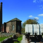
Edit Template

Walks In Derbyshire

There really is no better way to see the beautiful area that we live in than to walk in Derbyshire. Over the years we have walked what feels like pretty much the entire of Derbyshire and Nottinghamshire and feel it only right to share those walks with you. In every edition of Country Images Magazine we feature a walk for you to follow and now we’ve put them online for you to read too. If you have a mobile or tablet, why not follow the walks on it, with a map and an explanation of where to go it’s ideal for you to follow so as not to get lost. We hope  you enjoy the selection below and check back regularly for new walks.

 
  • All Posts
  • Walks
Walk Derbyshire – Following the Magpie Sough

December 2, 2022

By Rambler ‘Sough’ is the lead miner’s term for the method of draining water from a mine. One of the most attractive roads through the Peak District, the one between Bakewell and the A515 Buxton/Ashbourne road takes some beating.  Around a mile beyond the cut-off for Monyash, to the right two small chimneys indicate the presence of a major relic of local industrial heritage.  The chimneys and ancillary buildings, plus an old stone cottage are all that is left of boom to bust underground activity in the search for lead.  This is the site of Magpie Mine where fortunes were made by intense inter-companies rivalry that even lead to murder. While lead ore mining may have been active in small near-surface activity for hundreds of years, the earliest recorded evidence of miners beginning to explore ever-more deeply came in a report dating from 1740, the start of upwards of a dozen small lead mines that developed as time went by.  Local and even itinerant Cornish miners, searched for the riches available in upwards of eight major veins running roughly east/west ever deeper beneath the site.  It was also quite normal for abandoned mines to be re-opened by other companies, simply by asking permission from the local Barmote Court, the traditional means of controlling lead mining activities in the Peak. Due to the proximity of adjacent veins, two or more mines could be operating within only a few feet of rock between them.  This was the case in 1833 when teams of Magpie miners from Maypit and Great Redsoil mines came into dispute over the right of Maypit miners to open a side passage, inevitably connecting to Redsoil.  Appeals to the local Barmote seemed to be getting nowhere and arguments, sometimes verging on violence, broke out from time to time.  All...

Walk Derbyshire – Toad’s Mouth, Carl Wark & The Upper Reach of Burbage Brook

October 25, 2022

There are many enigmatic remains throughout the Peak District; stone circles, cairns and burial mounds were left by people who did not tell us who they were.  Carl Wark the focal point of this walk is one such relic, but we have no way of telling if it was Iron Age or post-Roman, but it tells us that the people who used it had to protect themselves from attack by unfriendly others. When gentlemen took their ease by squinting along the barrel of an expensive shot gun aimed at some innocent moorland grouse, or semi-wild deer, chances are that many of them would have used nearby Longshaw Lodge for their accommodation.  During the Great War, the lodge was used as a convalescence hospital for wounded Canadian Soldiers; there is a photograph of a group of them in the snow below the house; it stands beside the path in front of the lodge. With the decline of moorland shooting for so-called pleasure, the moors over which the hunters stalked has been handed over to the National Trust where anyone can wander freely along footpaths crossing the unspoilt moors and wild oak woods covering the valley sides of the lower Burbage River, all the way down to Grindleford. This walk starting from Longshaw joins a roadside path beside the aptly named Toad’s Mouth rock, before wandering out on to Hathersage Moor.  At its centre the well-preserved prehistoric fort of Carl Wark sits enigmatically below the wild rocks of Higger Tor.  Despite its condition, little is known about the fort’s history, remaining as a potential site for some future teams of archaeologists to work on. A path climbs directly across the moor to reach the massive stone defending walls of Carl Wark fort, by one of its two entrances.  At this point the...

Walk Derbyshire – Around Kedleston, Woods & Parkland

September 29, 2022

Opening my latest copy of WALK DERBYSHIRE the seventh no less, I realised that the first walk in the guide took in much of Kedleston’s parkland, but less than half of its beautiful woods and plantations.  As enjoyable as the walk maybe, it would be a great pity to exclude the extensive woodlands covering North Park and Hay Wood just across the ponds in front of the hall. A signposted path starting near North Lodge on the back road from Derby, winds its way in and out of woodlands. This is where mature oaks have grown for so long that the Ordnance Survey has confidently marked them on its maps covering the area between Quarndon and Kedleston. Starting from the National Trust car park to the rear of Kedleston Hall, at first the walk follows the hall’s access drive, round the front of the hall, and then down to the graceful bridge designed by Robert Adam to make a perfect foil for the view of the hall built to architect Paine’s plans.   A long stretch of narrow lakes created by damming Blind Brook reach out on either side of the bridge, with the drive continuing, past a golf course before joining the main road at North Lodge, the main entrance to Kedleston Park. A path starting on the edge of woodland enclosing North Lodge, bears left along the edge of the wood before swinging left to follow the boundary of Bracken Wood.   A narrow belt of trees shelter a side track which is crossed, (it leads to the estate‘s saw mill).   On the far side of the track, the path continues, slightly uphill through Hay Wood for about three quarters of a mile in order to reach the head of the long line of narrow ponds.  At...

Walk Derbyshire – Bretton Clough

September 2, 2022

Starting from a popular pub, the Barrel Inn, which is the focal point of the hamlet of Bretton, a small hamlet high on Eyam Edge, the walk enjoys delightful views over the surrounding countryside. Wooded valleys, one of which, Bretton Clough, is the focal point of this walk.  By tradition Bretton Clough is where the last Britons lived.  Unfortunately there is no evidence to support this story, but it is good to imagine these ancient Britons holding out against the invading Roman legions, invaders who came this way in search of lead, for which they planned to use local tribesmen as slave labour.  The only proof backing this legend are the remains of a Roman fort called NAVIO near Bradwell, an ancient lead mining settlement.   Two historic small towns or villages lie close to Bretton Clough.  Eyam to its south east has gone down in history as the village which managed to stave off the worst rigours of an outbreak of the dreaded plague by isolating itself for over two years.  Bretton Clough points the way to a much larger village, Hathersage.  It became Morton in Charlotte Brontë’s Jane Eyre. She also used places such as North Lees Hall as settings for much of the ever popular story-line.  Earlier still, Hathersage is said to have been the home of Little John, Robin Hood’s friend and right-hand man.  Who this man as is uncertain, but a grave close to Hathersage church door, when it was excavated, proved to contain the skeleton of a very tall man, as confirmed by his 32 inch thigh-bone.  Both these villages can be seen from views over the northern portion of the White Peak, together with the gritstone outcrop of Stanage Edge escarpment filling the eastern distance beyond the walk. Gliders soaring gently on thermals...

Walk Derbyshire – Historic Deepdale – A walk back into history

July 26, 2022

Deepdale you may ask, for the name doesn’t appear on any Ordnance Survey map?  Now better known as Dale Abbey, the village was once called Depedale, then Deepdale and eventually the modern name, Dale Abbey in remembrance of the abbey that flourished here from 1162 until Henry VIII’s quarrel with Rome in 1536. A lonely stone arch that once framed a glorious east widow, is all that is left of a Premonstratensian abbey taken over from Augustinian monks who came to this spot from Calke Abbey in 1162. They managed to begin building, but lack of funds led to the work being transferred in 1204 to an off-shoot of the wealthier Premonstratensian French foundation based in Lincolnshire.   Small by monastic standards, their work led to the draining of surrounding boggy land and the expansion of farming began alongside iron production using raw materials dug from the local countryside.  All went well until the Dissolution when the governing abbot managed to stave off the abbey’s closure by payment of a fine.  Unfortunately this was wishful thinking and gradually the abbey fell into disuse. Stones from the abandoned abbey found its way into the walls of surrounding cottages and local churches.  It is still possible to trace the use of these stones in some of Dale Abbey village’s older houses. The best example is in a cottage close to the village green.  Its foundations and the lower walls support attractive half-timbered main walls.  Apart from the lonely arch of the east window, a section of the abbey, in this case part of the kitchen, has been incorporated within a cottage close to the field containing the grassed over remains of the rest of the abbey.   Unlike other and more extensive monastic relics, the abbey ruins stand on private land, but...

Walk Derbyshire – The Roaches

June 29, 2022

As a few members of my brood have a nought at the end of their birthdates this year, we decided to celebrate by holding a family get-together.  The venue decided upon was the Mermaid Inn, an old drovers’ pub high on Morridge Ridge above Leek.  Due to the change in drinking habits following the ‘drink/drive’ regulations, the pub was fast losing its traditional clientele and either had to close, or change to something better than simply being a supplier of alcoholic drinks. The scheme a developer came up with was to improve the place by changing it into a high class self-service guest house, something that was perfect to our requirements as it easily covered the demands of a family group whose ages ranged from a few months to ninety.  By some miracle of organisation, everyone was free for the chosen weekend and travelled safely from points north, south, east and west without too much difficulty. The Mermaid by the way, takes its name from a nearby moorland pool, the haunt of a mermaid who is supposed to snare unwary travellers.  Overlooking the head waters of the River Trent’s highest tributaries and on high ground opposite the long ridge known as the Roaches, it makes an ideal base for anyone wishing to explore both the Roaches and Dane Valley as well as the little known areas above the headwaters of the Manifold Valley. It was the Roaches which attracted me most strongly.  As an area I have neglected as of late, I decided to take time off and re-explore this long sinuous arm of gritstone, the last fling of that rough stone marking the southern end of the Pennines.  The name ‘Roaches’ is supposed to have been conjured up by French monks based on their now ruined Dieulacress Cistercian Abbey...

Load More

End of Content.

We hope you enjoy the walks, but check back regularly for more walks in Derbyshire and walks in The Peak District as we are constantly adding new ones.

Country Images Magazine

Featured Posts

Euromedia Associates Ltd

Country Images Magazine is Derbyshire’s leading independent lifestyle magazine, proudly rooted in the heart of the county and dedicated to celebrating its rich heritage, natural beauty, and vibrant communities. Each issue features a carefully curated selection of articles exploring Derbyshire’s history and landscapes, alongside the latest home and interior design trends, local theatre productions, cultural events, dining destinations, and lifestyle inspiration.

In addition, Country Images provides a trusted platform for showcasing independent local businesses, highlighting those that offer outstanding products, personalised service, and a genuine commitment to quality. Through thoughtful editorial and strong community connections, the magazine continues to inform, inspire, and connect readers across Derbyshire.

Euromedia Associates Ltd Logo