Walk Derbyshire – A Hike Through Dovedale & Beyond
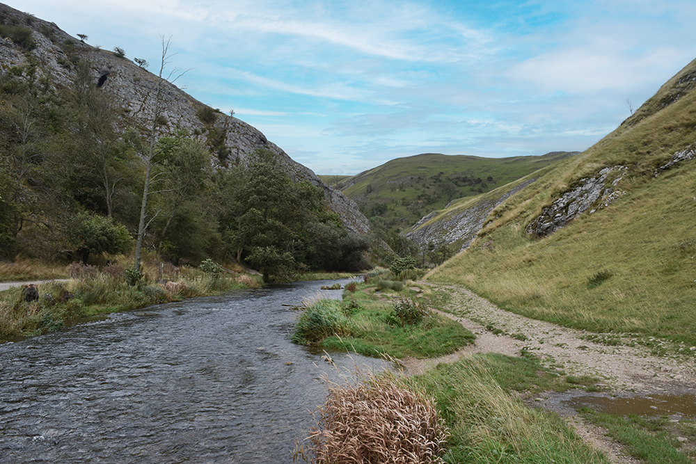
Dovedale is one of those iconic places in Derbyshire which everyone knows about, but finding a circular route can be a little tricky. You have a few choices on this walk to either walk down to the stepping stones, have a paddle, head up to Thorpe Cloud for the views or just picnic by the river. However, on an extremely wet September day we decided to venture a little further and enjoy a circular walk we had done once before. It is challenging though so best to be enjoyed on a dry day as the rocks are very slippery in parts. Also, the ascent is tough but there are a few tree stumps on the way up, should you need to rest your little legs. Along the way, we pass the stunning River Dove which is always teeming in wildlife. We pass by Thorpe Cloud (summit 287m) on your right, which you can always head up to before you start the walk if you want a really long hike. Thorpe Cloud and Dovedale were used as filming locations for Robin Hood (2010) with Russell Crowe. Dovedale is well known for its many limestone rock formations. On this walk you will pass Lover’s Leap where a young woman who believed her lover had been killed in the Napoleonic War, threw herself from the hill. Her skirt got caught in the branches of a tree as she fell which saved her life. When she returned home, she heard that her lover was alive. When you reach Ilam Rock, you can then turn around to see a formation called the Twelve Apostles. Details Parking: National Trust car park at Dovedale (£4 for 4 hours or £7 all day unless you are a NT member then it is free). Pubs: The Old Dog at Thorpe or a number to choose from just a short 5 minute drive away in Ashbourne. Distance: 7.85km 4.9 Miles Time: Approx 2.5 Hours Terrain: Quite tough, one big climb including steps. A few rocky scrambles. When wet many areas can be quite slippery. Walking boots are a must! THE ROUTE Head with the river on your right – you have a choice of straight ahead for the easy route to the stepping stones or cross the bridge on your right, then stick to the river to you left for a slightly more tricky (but more interesting) route to the stepping stones. If you went left of the river, you’ll need to cross the stepping stones when you get to them. If you went to the right you’ll already be on the right side to go through the gate and carry along with the river on your left. Follow the walk all the way along. You may spot Dippers and Kingfishers if you are lucky. Along the way you may also spot fossils in the limestone rocks on the path. You will eventually come to a bridge with a huge rock (Ilam Rock) to your left – cross the bridge and you will see a cave in front of you – bring a torch as this is well worth a look inside. However it’s usually flooded, so you may need wellies. We want to follow the public footpath to the right, then to Ilam via the steep ascent. And boy – is it a steep ascent! You will need good walking shoes. When you get to the top of the hill and it may make your ears pop– follow the sign left to Ilam. Follow the path through the trees, occasionally taking in the view on the left of the valley that appears between the gaps in the trees. You’ll eventually come to a gate, which you head through and turn left, follow along the steep grass (children will love sliding down here!) and you’ll eventually see a well worn little path in front of you amongst all the rabbits. When you get to the top, be careful, admire the view but the rocks are a little slippery. You will see a post on your left hand side. You can use either path here and you will come to a yellow footpath arrow signpost. When you come to the trees, you will notice that the path stops, so head right between two bushes up towards the top of the hill and then you will see a couple of yellow footpath signposts pointing to the right. Head up this hill towards the farm house. You will come to a wooden gate next to a barn – go through it and head left. There are farm eggs for sale here so bring some cash and a bag. Here you will see a random gorilla and a giraffe to your right– I kid you not! There is sometimes livestock in this field so be mindful. When you come to a gate head left, keeping the stone wall on your right as you walk up a track lined with trees. Carry on up the farm track where you will see a signpost on your right hand side ‘Bunster Hill’. Carry on up towards Bunster Hill. You have a choice here, there is a very steep path to the left or you can go straight to the bottom of the field to the stone wall. Head through the gate and down the field. When you come to the bottom where you can see the road and a farmhouse on your right – we are following the footpaths left all the way through the fields to eventually hit the car park. There is a choice at one point to not go through the livestock field. Gratefully back at the car park, the little kiosk was open so we were able to enjoy a well earned cup of tea and sausage roll! 00
Walk Derbyshire – A Walk Between Monyash & Flagg

If you were living in the Peak District countryside around a hundred years ago, the chances are that you would be following a dual working schedule. Part of your working day would be tending the needs of a dairy herd and maybe carrying out a little ploughing and growing feed crops for those valuable cattle. The other and entirely unrelated occupation could be spent underground, frequently working alone with nothing to help see what was in nearby rocks, other than by candle power. Tools would be a simple pick and shovel. The last independent Peak District lead miner was the late C.H. Millington who lived in Monyash. The name Monyash frequently leads to much argument with pros and cons on two sides. There are those who say the name means ‘Many ash trees’, but the more widely read side disagree, saying the name should be based on Maneas, a title that seems to have been popular as far back as early records indicate. Apparently Maneas means ‘wet lands’ in Saxon, a fitting title for a village built on an ancient clay bed 5million years old. This clay deposit has allowed five ponds to provide drinking water for cattle, (plus one now in-filled as a car park). All those currently in use, are to the south of the village green, with Jack Mere to the north used for parking cars. Monyash is built around a small clusters of cottages and a network of popular footpaths leading into Lathkill Dale form a linked network of field paths where lead miners would plod their weary way home after working underground after a day, still having to tend their cattle, or mow hay for their winter feed. Monyash was an important centre covering a section of the underground riches. The village even had its own Barmote court, an ancient system governing lead mining disputes and transfers of mine ownership. The village church is dedicated to St Leonard and was probably founded on the site of outdoor meetings around a simple wooden cross in the twelfth century. Adjacent to it is the village school and a stone preaching cross stands in the centre of the village green. The village has a small, but well-designed public hall that stands beside the Bakewell road on the east side of the village. The Golden Lion Inn closed in the early part of the 20th century, leaving the Bull’s Head to offer food and drink, together with a café in the converted blacksmith’s smithy next door making a popular venue for walkers, motorcyclists and non-powered cyclists. The pub has always been known as the Bull’s Head, apart from a brief interlude when the landlord decided to change its name to The Hobbit. The change caused such an outrage that it had to revert to its old and trusted Bull’s Head title. The plinth for the village cross is marked by many small holes left by the blacksmith when he tested newly sharpened stone drills. The walk turns for home at Flagg a couple of miles to the North West, unfortunately it no longer has a pub, it closed a few years ago due to lack of custom in this comparatively sparsely populated district. Not enjoying the same size of water deposit, it does have sufficient issuing from underground which provides a supply for each house in the linear village, but little or none beyond. This is a linear village with its own manorial hall, but no longer can it manage to run a pub. While there are abandoned lead mines scattered around nearby fields, the village only supports two or three dairy farms. Many of the remaining dwellings have been modernised, giving the village a look of prosperity. As mentioned earlier, many of the surrounding fields were criss-crossed by farmers-come lead miners on their way to delve far below the surface. These paths are used on this walk, together with a couple of quiet back roads in order to follow this little used circular walk out to Flagg and back to Monyash. It should be easy to follow and makes an ideal walk when the spring flowers are coming into full bloom. Only a little over five miles of gentle meadow walking, it has the choice of two places of refreshment at the end of the walk. USEFULINFORMATION: A five mile (8km) easy walk, using well-made stiles to cross stone walls. RECOMMENDED MAP:Ordnance Survey Outdoor Leisure Sheet 24; 1:25000 Scale. The White Peak Area PUBLIC TRANSPORT:Bakewell to Monyash bus services PARKING:Jack Mere off road parking beside the Flagg road, REFRESHMENTS:Bull’s Head The Old Smithy Café THE WALK THE WALK THE WALK 1. The walk starts at Jack Mere Car Park (free parking) at the Monyash end of the Taddington and Flagg road. Walk northwards, away from Monyash village, to a road junction and then turn right at a signpost for about 30yds (46m). Cross over the stile on the left near the road junction (signposted to Taddington). Cross a series of meadows, using gates or stiles where necessary, closing all gates unless asked to do otherwise. Viewpoint. Look back towards the village. The church steeple is the focal point, but narrow strip fields, fossilised in their medieval plan, are all around. 2. Go to the right of a short belt of trees. Continue to cross boundary walls by their stiles. Reaching stiles to the left, cross a boundary wall as indicated by yellow arrows. Walk on as far as a track junction with the road. Start to walk gently uphill. Strips of mature woodland in the Peak District have a dual purpose. Not only do they provide windbreaks on the exposed upland, but their main purpose was to keep cattle away from poisonous lead waste left by mining activity 3. Cross the road and walk down the cart track. Ignore a waymarked path marked by numbers eight, diverging to the right, and continue uphill along the lane. Notice the heather growing on either side of the lane.
Walk Derbyshire – Fernilee & The Goyt Valley

The South Manchester town of Stockport gets most of its water from two reservoirs filling the narrow upper reaches of the Goyt Valley near Buxton. It is hard to realise that this was a self-supporting estate with its own coal mines and small industrial estate where gun powder was made. Errwood Hall, the central building in this complex, its ruins now partly hidden in a side valley draining from high moors to the west, was the home of the estate’s owners. The family’s children were educated by a Spanish governess. Loved by the children, when she died prematurely, her grave was placed in a beautiful woodland situation, alongside senior members of the Grimshaw family. There is also a wayside shrine above the valley. More akin to those in the Alps it stands high on the hillside, below the summit of Long Hill road and is usually decorated by floral tributes. The Upper Goyt Valley is surrounded by high moorland surrounding mature pinewoods, to the west is a long ridge that overlooks both the valley and sweeping hills dominated by Shutlingsloe, Cheshire’s highest hill, a steep sided cone that can claim the title of a peak, a rarity in a county more commonly known for its low-lying or flat-topped hills, than sharp-tops, better known as peaks, proof that the word ‘Peak’ in the title of the Peak District has nothing to do with sharp-pointed hills. The meaning behind this expression is said to connect the district to the tribe of ‘Peaclonders’’ who inhabited the region in Celtic times. The eastern side of the valley is mainly open treeless moorland overlooking the spa town of Buxton far below. The heights of Combs Moss, one of the Peak District’s lesser known features, shelters Buxton from most of the cold scouring winds blowing in winter. A railway, one of the earliest lines in the country, entered the realms of the Goyt Valley by passing through an abandoned tunnel cut through Burbage Edge on Goyt’s Moss. Originally catering for horse-drawn wagons, it pre-dated steam and as it was originally constructed by canal-builders who were unable to take on the idea of trains of goods wagons climbing by their own power, the line was cut as though it used locks to climb up or down hillsides. As a result, the line from Cromford Canal to the Peak Forest Canal at Whaley Bridge, climbs the dry limestone hillsides aided by fixed steam engines at several points along the way. One of these steam driven haulage sections is now used as a surfaced road leading steeply downhill beyond Burbage Edge from Long Hill to the dam that created Errwood Reservoir and is where the walk begins. The walk is in two halves. Leaving Errwood Reservoir and the road at the western end of the dam, a woodland path is followed steadily downhill towards the western bank of Fernilee Reservoir. Beyond this point, the path begins to climb steadily, before dropping down to a track along the dam wall. This track is followed, soon uphill, to the Long Hill Road. This famous road, is followed to the left for a few yards in order to join a farm track bearing right towards the edge of a wood. The field track joins a minor road for a short distance, climbing past a farmhouse to where the road bears left. Do not continue along the road, but turn right and cross the nearby stile. Walk down the field as far as the road and join it, to the right as far as a sharp right-hand bend. Here we must climb over a stile and go steadily downhill towards a stream. Climb steeply up the far side and aim for a ruined barn in order to downhill on a grassy path. On reaching the road beside Bunsal Cob, turn right and cross the dam wall back to the car park. THE WALK :: THE WALK :: THE WALK • From the car park beside Errwood Reservoir, drop down towards the maturing pinewood at the head of Fernilee Reservoir. Follow its bank until the path begins to bear left, uphill. • Turn left and climb uphill for about 100 yards to join an upper path. Turn right at this point. • Climb the stile above the end of the reservoir and turn right, away from the reservoir, following the dam wall. • Bear half-left along the reservoir access road at the end of the dam wall and then climb up to the main roads. • At a signpost, turn sharp right and walk steeply downhill towards the head of Fernilee reservoir. Turn left and follow the reservoir for about a quarter of a mile. • Where the path meets is a deeply cut stream. • Turn left and follow a footpath on its far bank until it joins an upper path and turn right to follow it. • Walk on through mature pinewood and cross over another stream, feeding the reservoir. • Drop down to the western end of the dam wall and turn right. • Cross a stile and turn right to follow the farm lane over the dam. Begin to climb bearing left uphill from the dam’s far end. • Turn left on reaching the main road and follow it for about 100yds. • Climb over a stile overlooking the road and turn right to follow an uphill path, heading towards a farm lane but not reaching Overhill Farm. Keep well to the right of the farm buildings. • Turn right, following the farm lane for about 80 yards and bear left to cross a stone wall by a stile. • Aim uphill past a small plantation. On reaching the moor lane, turn right and follow it past an isolated house. • Walk on for about 150 yards until the lane bears sharp left. Do not follow it round the bend, but turn right to cross a dry-stone stile. • Do follow the path leading directly into the valley to
Walk Derbyshire – The Four Villages Walk – Brassington, Ballidon, Parwich & Bradbourne

I am indebted to Amber Valley Group of the Ramblers Association, as it is they who first planned this interesting walk. Despite their good work, especially in producing the excellent leaflet I picked up way back in 2005, regrettably the leaflet is now out of print, but luckily I came across a rather dog-eared copy the other day, which helped me to follow my version of their described walk. I enjoyed it so much that it prompted me to carry out some research into the history of these ancient places of worship, together with the villages they have served since Saxon times. Here is my version. Starting from the small car park above Brassington, the route soon passes St James,’ a church with at least Norman foundations, if not earlier. It has served the village for centuries, a focal point for generations of lead miners who delved far beneath the nearby grassy moors. The only link with this long-dead industry is in the name of one of the local pubs, The Miners’ Arms, and a smoke-stained cave high on jagged Rainster Rocks. This is where a miner and his family lived as described by Daniel Defo in his book about a journey through England in the early 1700s. His description of the family living like a group of troglodytes clearly brings to life the harsh conditions of a life dependant on living and working in stygian gloom for days on end. First mentioned in local records around 1281, when its Norman foundations were laid on the site of an earlier Saxon oratory, is St James’ church. The present church, Grade II Listed, is the result of the Victorian craze for ‘improvements’, such as the embattled parapet added to the Norman tower, but at least they left the plain bowl of the font, untouched since Saxons ruled the land. Many of the cottages in Brassington date from a time when they housed families more prosperous than Defo’s troglodytes. The village layout would not pass today’s planners, and as a result we are left with a cat’s cradle of narrow streets and ginnels, all just waiting to be explored. Moving out of the village and following a narrow lane, the walk crosses the B5056 Bakewell to Fenny Bentley road. Joining a short section of the Limestone Way, it skirts Ballidon where a tiny chapel originating from the 13th century is built on the footprint of a much older edifice. The village itself is tiny, sheltering under the protection of White Edge and Blackstone’s Low, today it caters mainly for the needs of quarrymen’s, or heavy goods drivers and their families. The Limestone Way is followed through fields, as far as Parwich. This time it is the Victorian adaptation of a Norman church and many of the game animals inhabiting the district in medieval times are represented within. Once a subsidiary Chapel in Ashbourne parish, it stands as it has done since the first monk, preaching beside a rough stone cross, brought Christianity to the pagan Saxons. They were the earliest settled people to live in this sheltered hollow. The church we see today is listed Grade II and seems to have ministered to the needs of a gradually swelling population, one of whom at least, if his 12th century grave cover is anything to go by, joined one of the Crusades in medieval times. Parwich is sheltered from cold winds blowing from the north, by a grassy hill. Here an 18th century Manor Hall surrounded by pretty gardens, overlooks the grey-stone village houses surrounding a small green. Finally Bradbourne’s Grade I Listed All Saints, dates back to the 13th century, but like the others in this quartet, probably dates from a much earlier chapel. A weathered Saxon Cross has stood in the churchyard since around 800AD. The Old Hall and other interesting des-res buildings line the surrounding village. The actor Alan Bates is buried in the graveyard to the rear of the church, alongside other members of his family. A quiet stroll along a farm lane leads back to Brassington by way of a series of fields lined by farm houses and a scattering of other attractive houses. The track reaches Brassington conveniently close to the Gate Inn, but if it is crowded the Miners’ is an alternative just a little further into the village. USEFUL INFORMATION: A moderate walk by field paths through meadows and along quiet country lanes, covering 9miles, (14.5km). One busy road, the B5056 Bakewell/Ashbourne road is crossed twice. Muddy sections in fields between Ballidon and Parwich. RECOMMENDED MAP: OS Explorer 1:25000 OL24, the Peak District, White Peak Area. CAR PARKING: Small car park in Brassington Quarry off the Wirksworth road out of Brassington. PUBLIC TRANSPORT: Buses from Ashbourne. REFRESHMENTS:Pubs in Brassington and Parwich. THE WALK – STEP BY STEP Turn left outside the car park and walk down Dale Road for about 100yards towards the village, and then go right on into a narrow road leading towards the church – (use the church tower as a guide). Follow Church Street until it joins Hillside. Turn right here and walk uphill for about 150 yards, then go left at a footpath sign, following it until it reaches the head of a field track going left. Turn left along the track, and follow it downhill when it becomes Pasture Lane and is metalled. Cross the main road with care and go through the gate opposite. Follow the gently rising track as far as a solitary standing stone. Turn left off the track here and keep to the left of the stone, aiming for a stile in a stone wall about 100yards away and cross the stile. Beyond the stile go steadily downhill, soon to aim for tiny Bradbourne Chapel. Follow the concrete path behind the church, down to the road used by heavy traffic serving the nearby quarry. Turn left and walk in single file on your right of the road and look out for a footpath
Walk Derbyshire – Tideswell, Miller’s Dale and Litton

The history of the Peak District is writ large on this walk. Starting way back in time when volcanoes spewed out their lavas, the walk enters one of the loveliest dales in the White Peak, but it was where orphaned children were unable to enjoy its delights. Climbing out of the dale, the way is across fields whose layout would still be recognised by the medieval farmers who ploughed their furrows with pairs of oxen. Two villages come next, Litton and Tideswell, the latter with its church classed as the ‘Cathedral of the Peak’. From there the way back to the car park follows back roads and footpaths laid out well over a hundred years ago. The volcanic activity mentioned above took place in what is now known as Tideswell Dale. The hillside to your left, on walking down the dale, has some quarried areas of dark coloured rock between layers of limestone. These are the remains of lava flows that spewed out of volcanic vents surrounding a tropical lagoon that once covered what became the White Peak of Derbyshire. At the dale end the path joins the main, or Miller’s Dale down which flows the clear waters of the Derbyshire River Wye. A mile or two downstream the river enters its prettiest section, aptly called ‘Water-cum-Jolly Dale’, but before it reaches this sylvan glade, the river once powered a cotton mill whose young operatives lived a life of hell. This is Litton Mill to which orphaned children were brought from workhouses as far away as London to enter a life of cruel servitude as so-called apprentices. Nowadays the mill having ceased production, has been converted into apartments and its subordinate cottages are now lived in by locals whose ancestors may well have been those orphans apprenticed to slavery. There were two cotton mills along this section of Miller’s Dale, and depending on fate, any child not destined to the cruelty of Litton Mill might have found itself working at Cressbrook Mill a few yards beyond the delights of Water-cum-Jolly. These children although still used as cheap labour, were by comparison with their brothers and sisters upstream treated more fairly. The place where they worked was called Cressbrook Mill. Like its partner, the mill stopped spinning cotton decades ago and like Litton has been converted into apartments. Climbing out of the main dale, the walk follows Cressbrook Dale where this salad plant was once gathered as a cash crop. Using a woodland path until it reaches open pastures, a side path climbs narrow Tansley Dale to reach Litton village. This village where the locals run a co-operative store selling basic foodstuffs rather like the original self-help founders, has a welcoming pub as well as a tea room attached to the shop. Narrow fields surrounding Litton and its larger neighbour, Tideswell are known as strip fields designed to be ploughed in one day by a team of two oxen. A quiet side road leads from Litton into Tideswell. Once the major town in this part of the Peak, its parish church, aptly called the Cathedral of the Peak, speaks well of Tideswell’s one-time even greater prosperity. Being on what was once a busy cross-country turnpike, it still has pubs that once welcomed travellers on not-so-comfortable mail coaches whose horses could be changed here. Useful Information 6 miles (9.7km) of moderate walking along paved paths, valley bottom woodland ways and limestone upland field paths. 690ft (210m) climb. Muddy sections, especially after winter rain. Recommended Map. Ordnance Survey Outdoor Leisure Map – Sheet 24, the Peak District, White Peak Area. Refreshments: Tea rooms and pubs in Litton, Tideswell and Miller’s Dale. Public transport: Chesterfield/Tideswell service: (Buxton route) – G&J Holmes/Hulleys number 66. Parking. (Pay) is at the head of Tideswell Dale (B6049) The Walk Follow the partly surfaced path down Tideswell Dale from the car park and toilet block. Swop sides at the fork and go over a small wooden bridge, continuing to walk downstream. A side path on the left a hundred yards from the start of the walk leads up to a small quarry where the basaltic lava was spewed millions of years ago. Entering Miller’s the main dale, turn left along the valley-bottom road and follow it to Litton Mill. Go through two imposing gateposts and walk through the mill yard, bearing right on a concessionary path. Continue to your left down the dale. Although the rest of the mill is private, it is still possible to see the pipework of a turbine which powered the working mill in its later years. Look out for birdlife as you follow the River Wye in its twists and turns down the dale. Spend time admiring the view of Water-cum-Jolly Dale. N.b. the path is sometimes flooded at this point, so keep well to your left. Keep to the left of Cressbrook Mill and follow the path as far as the road. Turn left along the valley road and where it begins to climb, take the right fork still going uphill. Leave the road where the road doubles back uphill, and walk forwards along a woodland track. Beyond a group of cottages, continue ahead on a narrow woodland path climbing steadily up Cressbrook Dale. Where the path goes downhill at a clearing, follow it over a narrow footbridge and climb steeply uphill from the far bank of the stream. Reaching a boundary wall at the top of the slope, do not cross the stile but begin to go back downhill in order to cross the dale. At a junction of paths close by the stream, cross the latter by way of stepping stones and begin to climb Tansley Dale. At the head of this dale start to bear slightly right and cross a series of narrow fields, using stiles to keep on course. Bear left on entering a narrow track accessing the fields and follow it for about twenty yards and then go to your right into a field. Walk diagonally left
Derbyshire Walk – Tissington

I had visions of Michael Fish, the man whose forecast about there being no danger of hurricanes, went as his Scots forebears would have put it; ‘gone aft a’gley’. In my case it was a completely wrong interpretation of the forecast. According to a weather map in the Guardian a day or so before the planned walk, the weekend weather should have been dull at first, then sunny. Perfect I thought but after the first hour’s walking, instead of sunshine, we had snow, not much, but enough to make us wonder if we had done the right thing, but by then we were well into the walk, and had to plod on regardless. This walk rather than be between two grand houses, aims for just one, Tissington Hall as its high point. Starting from the little known village of Parwich, the way is across the valley of Bletch Brook, then by way of a short length of the Tissington Trail to the estate village of Tissington. The return follows a more northerly route, across fields and then over Bletch Brook once more. It then travels back to Parwich where Robinsons’ a renowned Stockport brewery supplies the Sycamore – their ‘Old Tom’ was a warming respite at the end of a bitterly cold and damp walk. The two villages visited on this walk are built on ancient foundations. Parwich can almost be classed as a hidden outpost. Its secluded stone-built cottages sit around a pleasant village green filling a sunny hollow and can claim to be one of the least known Peakland villages. The church is built on Saxon and Norman foundations, but like many of its kind was ‘improved’ during the Victorian zeal for modernisation. Its hall though dating from 1747 is not built from the plentiful local stone, but from bricks that were made on site in temporary kilns. Standing on a south-facing terrace overlooking the village, the house and its gardens are only opened to the public on advertised days. To the south on the opposite side of Bletch Brook valley, Tissington is an estate village clustered around its Jacobean hall. Both have been owned by the Fitzherbert family since Elizabethan times. Although not on the route of this walk, the village is entered by a side road off the Buxton/Ashbourne highway, along an imposing avenue of lime trees. With its attractive duck pond at its centre, Tissington is popular with visitors throughout the year. Some may come just to sight-see, or picnic beside the pond; others seeking more energetic pursuits make for the old station car park on the Tissington Trail in order to cycle or walk along the all-weather track. Whatever it is that brings visitors to Tissington, the majority will be arriving in May around Ascension Day when Tissington is the first Peakland village to dress its wells. Tissington Hall is open to the public at advertised times and fulfils everyone’s idea of how an ancient house can still be a pleasant family home. Cream teas are usually on offer and the rose garden is a must throughout the summer months. The Walk : From the village green in Parwich, follow a side lane southwards towards rising ground. Look out for a shallow cave on your right and go through an awkward squeezer stile next to a farm house. Follow the line of a hedge, down to the slopes leading into Bletch Brook valley. Walk down four fields into the valley bottom where it can be muddy. Cross the stream by a footbridge. Climb uphill, following the route indicated by a Limestone Way signpost, crossing stiles in the walls of three fields until you reach a farm lane. Cross the railway bridge and, on its far side, turn sharp left and go down to the track bed of Tissington Trail. Turn right and follow the all-weather trail. Tissington Trail follows the Ashbourne/Parsley Hay stretch of the old railway from Uttoxeter to Buxton via Ashbourne. Never economical, it was closed following the Beeching report. Walk along the trail for about ¾ mile (1.2km), as far as Tissington Station car park and picnic site. From the car park, go left into the village, then right opposite the duck pond. Go past the café and then Tissington Hall on your left. The attractive Hall Well on your right opposite the hall entrance, is just one of the Tissington wells dressed each year. Turn right at a road junction and a group of cottages beyond the hall at the far end of the village. Turn left by the last cottage and follow a signposted, waymarked field path across five fields, crossing walls by stiles, or go through field gates. Low ridges in the fields crossed by this section of the walk are the remains of medieval field systems when ploughs were hauled by teams of oxen. Keeping to the right of Crakelow Farm, cross a railway bridge over the Tissington Trail. Keeping slightly to the right, walk downhill into the valley by a pathless route crossing four fields. Keep to the right of an old field barn. Cross Bletch Brook (muddy on either side) and climb the hillside by following a boundary hedge. Cross two more field boundaries along the way. Drop into and follow a sunken track. Go through a squeezer stile, moving away from the sunken track and over a field. Aim to the right of a ruined barn, then climb over another stile in a boundary hedge. Walk downhill towards the bottom corner of a field. Go through two gates and then join a minor road. Turn right and follow the road back into Parwich village. Useful Information 3¾ miles (6km) of moderate field path walking. Gentle climbs on either side of the Bletch Brook valley. Some muddy sections in the valley bottom. Recommended map: Ordnance Survey: 1:25,000 scale Outdoor Leisure Sheet 24, the White Peak. Refreshments: Tissington café. Sycamore Inn, Parwich. Public transport. Although the Derbyshire Connect service could be used; telephone bookings, (01332)