Walk Derbyshire – Where Izaak Walton Fished – Hartington

Izaak Walton, seventeenth century author of ‘The Campleat (sic) Angler – The Contemplative Man’s Recreation’ would have been familiar with at least half of this walk. The Dove was one of his favourite places to cast a fly, along with his younger friend, the impecunious Hartington landowner, Charles Cotton. They regularly fished the river’s clear waters, mostly below Hartington, especially favouring the quiet pool opposite Cotton’s home at Beresford Hall. This quiet spot they named Pike Pool in acknowledgement of a monster pike that traditionally lay in wait beneath the shadow of the tall pillar, or spike of rock rising from the deepest and shadiest part of the pool. In the treatise, Walton calls himself VENATOR (traveller) and Cotton is known as PISCATOR (angler). Charles Cotton had a fishing temple built as a resting place for them, it still stands behind a high stone wall in the grounds of now demolished Beresford Hall, but being on private land the only time to catch a glimpse of it is in winter when the surrounding trees are bare. The Dove flows through two accessible dales below Hartington which are followed on this walk. Named in some far off time, these are Beresford and Wolfscote Dales, just waiting to be explored after the walker climbs down through comparatively dry Biggin Dale on the way back to Hartington. Leaving the riverside path and following a short walk across fields beyond the head of Beresford Dale that would have been familiar to the two angling friends, the village is reached after a mere fifty yards of road walking. Hartington has long been a busy village. A market place for locals until a few decades ago, but now the only agricultural industry is the delicious Stilton cheese, made in one of only a handful of places allowed to call the product of its dairy, Stilton cheese. A small converted cottage beside the lane down to the dairy now serves as a shop selling this and other locally made cheeses. The closest the village comes to running a market is on one of the annual events organised locally. Ancient Britons would have known the rich valley land on either side of Hartington and it is believed they fought Roman legionaries on nearby Hartington Moor, perhaps in a dispute over the Roman plan to build their road from Derventio, Derby to Aquae Arnemetiae, their spa which still produces warm water in present day Buxton. Many great and famous personalities have either lived or stayed briefly in and around the village. Literary giants and philosophers, such as Doctor Johnson, fully enjoyed the delights of the shady dale, still unchanged thanks mainly to the care given by the Peak District National Park Authority, or the National Trust, an organisation that owns many sections of the dale, mainly acquired through the generosity of donors. While the walk passes through these three secluded dales and over lush meadows, it runs close to Biggin, one of the least known villages in the Peak District. It is hard to believe that during World War 2, there was a large POW camp close to the village on land now used for sheep auctions. A degree of freedom was offered to trustworthy prisoners who worked on surrounding farms, many of them later recalling their affection towards the Peak District countryside. Hartington Hall, a Jacobean manor house at least 300 years old is now a high standard youth hostel, very much in keeping with a resting place where Bonnie Prince Charlie is said to have stayed on his abortive march on London, a march strangely abandoned for little or no reason at Derby. Useful Information A moderate 5 miles (8km) walk across fields, followed by two dales alongside a famous trout stream, beyond a short walk through a dry dale famous for its semi-alpine flowers every summer. Recommended Map: Ordnance Survey Explorer map, Sheet OL24, 1:25000 scale; White Peak Area. Public Transport: buses from Ashbourne and Buxton. Car Parking: Market Square (free), or pay and display in the car park next to the road towards the Manifold Valley. Refreshments: Two pubs in centre of village and a scattering of small cafés and shops around the market place. Refreshments can also be bought at the youth hostel. Directions From the market place follow the road eastwards, past shops and a café until it reaches a side road marked by a small war memorial commemorating the village dead in two World Wars. Turn right here and walk up the steep hill. Follow the road, uphill to the youth hostel, then turn right opposite its garden gates, into a walled un-surfaced track heading towards fields stocked with grazing cattle. At the end of the lane, go over a stone stile, then turn half right to cross two fields by an indistinct path – aim towards a clump of trees ahead next to a minor road. There are many interesting views both near and distant to be enjoyed as you walk across the elevated open fields. The prominent rise to the south west beyond the cleft marking Dovedale is Ecton Hill above the Manifold Valley, a one-time valuable source of copper, zinc and lead ore deposits. It is said that a Duke of Devonshire in the eighteenth century was able to use the profits from the mine to build the Devonshire Royal Hospital and its dome. Cross the stile beside the trees and turn left along the narrow metalled lane as far as a cross roads. Continue ahead on a rough cart track. Pass a well-made stone barn, then leave the walled track at a gate to walk downhill on an open path into Biggin Dale. Turn right and walk along the rocky dale bottom. Join the main dale as you pass a high limestone crag where harebells and other semi-alpine plants bloom in early summer. Turn right on to a rocky path and walk upstream beside the River Dove. The path fills a narrow ledge between the riverbank and
Glossop & Old Glossop
Like Hope, Hathersage and Chapel-en-le-Frith, Glossop was once a vast parish of over 50,000 acres, subsequently subdivided, covering the hills of the western Dark Peak. In 1086 it was part of an even larger entity, the lordship of Longendale, held directly by the king, and it remained as such except for a brief period under Henry I when it was granted to William Peveril. After the Anarchy however, Henry II gave it to the Cistercian Abbey of Basingwerk, Flints (now Clwyd) and they held it until the Dissolution. As a result, Henry VIII granted it to Francis Talbot, 5th Earl of Shrewsbury and it remained largely with his descendants, the Talbots and the FitzAlan-Howards, Dukes of Norfolk, until the twentieth century. Old Glossop sits on a south facing hillside, and originated in the medieval period. The modern town, initially Howard Town, later New Glossop and now just Glossop, was created around cotton mills in the early 19th century through the encouragement of the FitzAlan-Howards (whose coat-of-arms can be seen all over the place) and lies further down, occupying the valley. The name, according to modern reference books, derives from the Anglo-Saxon hop(e) (= valley), suffixed to the notional Saxon name of ‘Glott’ (in the genitive, hence an additional ‘s’), thus ‘Glott’s valley’. However, these references invariably prefix the name with an asterisk, which means it has been deduced by academics from the name’s earliest forms but is unattested by any known personage bearing it. Bearing in mind that the area probably remained under British control until near the end of the seventh century, one might propose a British origin for the first element, like Glôg (= a rock or knoll, appropriate enough hereabouts) or the well- attested British personal name Glywys, with the Saxon suffix added. Such hybrid place names are not uncommon, especially in the North and West and more are being admitted as research is re-defined. Such arcana did not affect our visit on a blazing hot day. Old Glossop is a total delight, and once was centered on the hall, latterly a vast, rather unlovely mansion, demolished by the Council in 1959 (see Country Images May 2018). This lay quite close to the church of All Saints, with a fine park rolling down the hillside. The church itself is an ancient one, and quite substantial, but has suffered numerous rebuildings – no less than five since the beginning of the 19th century, leaving little of the original 12th century church. We actually began beside the stump of the medieval churchyard cross, rather neglected looking, on the south side, by walking up from the church past the former church primary school of 1854 by Matthew Ellison Hadfield (1812-1885), a Glossop man, son of the Dukes’ local agent, Joseph, who, through the patronage of the Howards rose to eminence as an architect here and then in Sheffield as Weightman & Hadfield. He designed much of the new town of Glossop. The school is remarkably substantial, and was converted into several spacious houses three years ago, winning an award. We pressed on past up to the upper road, Church Lane continuing NW until we reached ‘the opposition,’ as one elderly local called it, the splendid late Regency Catholic church (also dedicated to All Saints) by M. E. Hadfield of 1836, although it looks almost earlier, with its neat classical villa of a presbytery beside it. It was the private chapel of the (staunchly) Catholic Dukes of Norfolk until 1925, despite the hall also having had an attached chapel. We then pressed on along Church Terrace until we reached the main (Woodhead) road, where we turned left down the hill into Glossop proper. Woodhead Road morphs into Norfolk Street, and for half a mile one passes through a leafy suburb with houses either side ranging from late Victorian to inter-war. Further down, things change: opposite the corner of Kent Road is a pair of stone built houses, very pretty, in an unexpected cottage orné style, followed by a substantial mid-Victorian terrace, with further terraces beyond on both sides. This continues for another country half-mile until suddenly the descent steepens and the road widens. On the right is the very striking Manchester, Sheffield & Lincolnshire Railway’s classical station of 1847 (by the omnipresent Hadfield, naturellement). The noble lion crest of the Howards atop the parapet attests to the fact that the 13th Duke personally paid for the one mile branch line from Dinting that terminates at the rather grand station itself. The line (later the Great Central, then 1923-1948, the LNER) is today still operating and long electrified. Opposite the station a very tall sub-Jacobean Conservative club of 1909 with a first floor angle gallery upheld by a stumpy fat column with stiff leaf capital. Further down, on the corner of High Street, we found the early Victorian Norfolk Arms Hotel, very welcoming, where we paused for much needed sustenance. This, essentially, is the grandly planned centre of Howard Town, later (New) Glossop. We proceeded along Henry Street to Norfolk Square behind the pub, where Tesco have tactfully adapted the station’s good shed, and passed, on our right, an Italianate building, now shops, and a hidden Masonic Hall, its modest entrance amidst a stone residential terrace looking almost furtive in its discretion but, from the notices advertising the availability of a large hall for weddings, funerals and bah-mitzvahs (as it were), we deduced that behind lay an edifice of noble proportions, invisible to us. Opposite lay sloping Norfolk Square itself bosky and with elegant buildings in the usual honey-coloured Dark Peak millstone grit on all sides. The NE corner is host to a tall Jacobean Liberal Club of 1914 by Paul Ogden, with blue plaque honouring Hon. Mrs. Mary Partington MBE a philanthropic ex-Mayor of the town and daughter-in-law of the largest employer in the Borough, Edward, 1st Lord Doverdale). Beside it is a splendidly Belle Epoque war memorial in bronze with winged victory (by Vernon March of Hadfield’s old practice)
Walk Derbyshire – A Winter Warmer Around the Longshaw Estate

I have to make an apology before embarking on the text for this walk. In July I acquired a new hip, this was after upwards of ten years trying to ignore an ever growing problem. Fortunately I had the sense to build up a stock-pile of walks, which kept Garry and Alistair happy at Images HQ, making it possible for them to publish my walks as and when necessary. Feeling a lot better since my session with Mr Williams, one of the osteopath surgeons on the staff at Calow Hospital where, I must add, I didn’t feel a thing, and was much entertained by what sounded like the opening bars of Giuseppe Verdi’s Anvil Chorus from his opera il Travatore! Deciding it was time to put my boots on again, I chose this walk mainly because it is short and finishes with the alternative of a pub lunch or the excellent soup and sandwiches on offer at the National Trust tea-room next to Longshaw Lodge. Using easy to follow paths through what was once a sporting estate, the walk drops down into the upper valley of Burbage Brook. Here it joins one of the ancient Pack-horse tracks that once linked Sheffield to the salt wells of Cheshire, and carried finished metal goods such as scythes on the return trip. With far reaching views throughout, the walk starts by skirting the front of the lodge, along a path between it and the open moors now grazed by sheep, but once the realm of sportsmen and their guns in search of game. Going through a swing gate, the path splits with one going south towards Big Moor, and the other bearing right, drops down to the Grindleford road. This is the one we took, going past an attractive pond, the haunt of wild geese. The path crosses the road by way of a stone stile and then finds its way down to Burbage Brook. An ancient stone packhorse bridge crosses the brook which is followed upstream to another stone bridge. Here a right turn joins a cobbled track winding its way up to the Grindleford road again. Diagonally right across the road there is a gate house and behind it a footpath through woodland back to the car park. Longshaw Estate and its lodge was built in the early 1800s for the Duke of Rutland as a sporting estate. During the Great War of 1914-1918 it became a military hospital, mainly for Commonwealth soldiers. From old photographs it looks as though many of the fitter soldiers managed to enjoy the heavy snowfalls that seem to have been more regular then than now. In the 1920s Longshaw was bought by Sheffield Corporation as an amenity for the city whose boundary cuts through part of the estate. While the lodge has been turned into private residences, the rest of the estate having been gifted to the National Trust, is open to all. The now famous Longshaw Sheepdog Trials take place annually in the large field below the main house. The Walk : From the National Trust car park, follow the path down to the National Trust tea-room and Information Centre. Bear right and then left on to the path running between the lodge surrounds and open fields. Follow this path up to a swing gate next to wild rhododendrons. To your left as you walk along the first path, the raised wall apparently supporting the ground above it is called a ‘ha, ha’, or ‘haw, haw’. Its purpose is to prevent stock from encroaching the built-up area surrounding the lodge, but without spoiling the extensive moorland view. Reaching the gate, go through it, bearing right alongside rhododendron bushes, where pheasants are often sheltering. Wooden signs at the side of the path point to where children might find places where friendly boggarts live. Continue along this path until it reaches a large pond. Skirt round the pond with it on your right and then bear left past the second stone barn before you reach the road. It usefully serves as a shelter in wet weather, as well as offering information about the surrounding countryside and its wildlife. Cross the road and go through a stone stile and then drop down to a stone pack-horse bridge over the narrow brook. Cross the bridge and turn right, upstream for about a quarter of a mile, as far as the next bridge. Turn right and cross the narrow bridge. Follow a cobbled path, winding steeply uphill and through woodland as far as the road Go diagonally across the road, heading towards a gate house. Follow signs past the gate house and onto a woodland track. Continue along the track back to the National Trust car park Useful Information : 3miles (5km) of easy walking on well-maintained estate paths and riverside and woodland tracks. Recommended map: as the walk cuts through the northern and southern edges of both the OS White Peak (Sheet OL24) and OS Dark Peak (Sheet OL1) maps, it can make map oriented navigation rather difficult, but hopefully my poor quality sketch map and written instructions will be sufficient. Public transport: Regular service between Sheffield and Grindleford stop at the Fox House Inn a few yards from the entrance to Longshaw Estate. Parking: Inside estate (National Trust members free). Refreshments: Fox House Inn and Longshaw tea-room and Information Centre. Annual sheep dog trials as advertised. Guided walks and seasonal children’s events throughout the year. +10
Walk Derbyshire – Around Winster

Winster is a haphazard cluster of seventeenth and eighteenth- century houses linked by narrow hillside alleys or ginnels as they are known locally. They sit in a pattern which suited the lead miners and their families in the hey-day of this now extinguished Peak District industry. The walk follows paths once trodden by miners who, usually in small groups, delved beneath the surrounding heights. Often run on a part-time basis, the miners would be satisfied with a daily input of enough ore to fill their wes’kit (waistcoat) pockets. Small abandoned stone barns, used as stores by these miners, still dot the surrounding fields. At the side of the nearby B5056 Cromford/Bakewell road, close to its junction with the Newhaven road, a communal lead store has been preserved as an interpretive feature. A little way down the road from it, the Miners’ Standard pub takes its name from the standard dish used to measure quantities of ore. In contrast with this small-time mining activity, the last and most productive lead mine in Derbyshire was nearby at Mill Close. It was still in operation until 1939 when flooding led to its abandonment. The central feature of Winster is a two-storied, late seventeenth-century Market Hall. Standing opposite the co-operatively run village store and post office, it was the first National Trust property in Derbyshire. Winster has its own team of Morris Dancers, and every Shrovetide the women and children of the village hold pancake races along the main street. Parking is difficult in the centre of Winster, but can usually be found roadside to the west (Elton) side of the church, or at a dedicated car park above the village near the Miners’ Standard. The Matlock to Bakewell via Elton bus runs through Winster (but not on a Sunday). The Walk : Walk up the side street away from the Market Hall and go past the Bowling Green Inn. Turn left at Hope Cottage to follow a footpath signposted to Bonsall. Bear left with it, passing the public toilets and follow a narrow alley, head out of the village. Using stiles to keep to the grassy path, climb diagonally right across a series of fields. From fields disturbed by ancient lead mining activity, look to your left across the wooded valley. Stanton Moor is to the right and beyond it are the rocks of Robin Hood’s Stride, once known as Mock Beggar’s Hall from its apparent shape in poor light at dusk. Further on, the deep trough of Lathkill Dale cuts a swathe through the limestone plateau. Looking to your right again beyond Stanton Moor, the wide swathe of the Derwent Valley carves its way past Chatsworth and into the gritstone moors of the Dark Peak. Go through a stile in the wall on your right and turn left following a wall close by Luntor Rocks. Then, following waymarks, incline right, uphill. A fenced-off area below Luntor Rocks marks the site of an abandoned mine shaft. Most mines but not all, are blanked off with concrete beams, or by beehive cairns. Treat every mine shaft with respect for many have unstable sides. At the top of the rise, go diagonally left across the level field, heading for a stile in the top wall. Cross the stile and turn left to follow the moor road for about a quarter of a mile. By the weight restriction sign, turn left down the first of two adjacent tracks. Keep to your right of the farm house, and then bear left to walk round the lip of a quarry. Begin to go downhill across open fields, bearing right at a path junction marked by a yellow arrow. Head towards a ruined barn. Turn left and descend towards a dry dale running roughly left and right. Cross it and climb to the right towards the outskirts of Wensley village. Follow the narrow street leading into the village and main road. Cross and, keeping to the right of the cottage opposite, follow a signposted path indicating the way to Stanton Moor and Birchover. Aim ahead towards woodland. Cross two fields and then follow a forest track. Climb over a stile and turn left, uphill along a surfaced lane. Fork left at the lane end, to bear left along a woodland track. The factory seen through trees on the right of the lane stands on the site of Mill Close Mine, once the most productive lead mine in the Peak. Starting in the 1700s, it had a chequered career until the mid-nineteenth century when more efficient pumping equipment made it viable for the next hundred years or so. The factory began by extracting residual lead from the spoil heaps, but now specialises in extracting lead and other metals from worn-out batteries etc. The preserved surface remains of the Old Mill Close Mine are passed close by on the next section of the walk. Take the left fork at the finger post and walk down into the valley bottom and bear right. The imposing tower of the Old Mill Close Mine winding house is to your right. A short diversion here is worthwhile, but do not follow the path in front of the winding house; return to the valley bottom path and turn right. Follow the path upstream through woodland. Bear left with the path in order to cross the stream and go over a stile. Using two old gate posts and stone stiles to indicate the way, go half-right then diagonally left uphill. Cross the stile at the valley head and turn right along the road back into Winster. Useful Information 5½ mile (9km), of easy/moderate walking on field paths. The path between Clough Wood and Winster has muddy sections after prolonged rain. Recommended Map: Ordnance Survey 1:25,000 scale Explorer Map, Sheet OL24: White Peak area. Parking: above the village near the Miners’ Standard, or roadside on the Elton road beyond the church. Public Transport: Hulleys 172 Matlock, Winster and Bakewell service runs at 38minutes past the hour
Walk Derbyshire – Foolow & Silly Dale

There are no records of any simpleton, either in Foolow or Silly Dale; both names come from Anglo Saxon English and have entirely different meanings than in today’s language. Foolow means multi-coloured hill, possibly a reference to nearby Eyam Edge. Silly is Old English for pretty, an apt description of this little-known dale, especially in late spring when the limestone-loving flowers are in full bloom. The walk starts and finishes in Foolow, a village of light grey limestone cottages, arguably the most picturesque in the Peak District National Park. There is a bay-windowed manor house and the Bull’s Head offers an excellent menu to satisfy the hunger of the hardiest walker. Until 1888 when the tiny limestone church dedicated to St Hugh was opened, church-goers congregated around the ancient stone cross and its pagan bull-ring standing next to the duck pond. Until 1932 when pipes were laid, water was a problem in this upland village. Before then villagers had to collect water from a well a little way along the Hucklow Edge road above the village. Cattle enjoyed the convenience of the attractive duck pond on the village green and in celebration of the gift of water, village wells have been dressed since 1983 on the Saturday prior to the last Sunday in August. Starting from Foolow the walk climbs up to Hucklow Edge before turning west and descending to the neighbouring village of Great Hucklow. This village, clustered around its pub, the Queen Anne, is really a group of five inter-linked hamlets where lead miners delving 600 feet beneath the ground, worked the riches of High Rake, following a series of inter-connected veins running north-westwards. Pack Horse teams once carried the ore together with Cheshire salt across the high limestone moorland, by trackways that can still be traced for miles. From 1938 until 1970, the playwright L du Garde Peach produced plays in the popular Playhouse theatre, based on an old barn in the village. Beyond Hucklow, the walk descends into Silly Dale and, on climbing out of it, crosses a series of green fields back to Foolow. Useful Information 3miles (5km) of easy walking along rural lanes, field paths and a flowery dale. Recommended map: Ordnance Survey 1:25000 scale Outdoor Leisure map The Peak District – White Peak Area Sheet 24. Refreshments: Bull’s Head (Foolow), Queen Anne (great Hucklow), pubs and cafes in Eyam. Public Transport: TM Travel 65 service from Sheffield and Calver Sough runs hourly Monday/Saturday and two hourly on Sunday. G&J Holmes/Hulleys 66 service between Buxton and Chesterfield runs two hourly from Chesterfield Monday/Saturday and three hourly on Sunday. Parking: roadside around Foolow village, but please do not block local access. The Walk : With your back to the duck pond in Foolow, take the road past the church and head towards Hucklow Edge. Follow this road for just under a mile. The old village well at the side of the road to your left is protected by a wall with a narrow stile to keep animals away from the one-time sole drinking water supply for Foolow, once a scarcity on these dry limestone uplands. Regrettably the water is now unfit for human consumption. Just before the road begins to climb steeply and bears right towards Hucklow Edge, turn left and cross a stone stile in order to follow a wall-side path. Gliders from the Gliding Club behind the edge can usually be seen soaring gracefully on the up-sweeping currents of air. Tree-lined hollows and rough ground uphill towards the edge indicate the position of abandoned lead-mining activity. Joining a narrow lane turn left and follow it until it reaches a side road. Turn left along the road, following it below a belt of trees. At the far end of the woods, turn left over a stile and follow waymarking arrows and splashes of paint down into the Grindlow section of Great Hucklow. Bear left along the village road and then fork right towards the main road. Cross the road diagonally left and right, then go to the left of a single bungalow. Follow the narrow, walled track, down into Silly Dale. Surface water has not flowed down Silly Dale for at least 10,000 years, when catastrophic floods marked the end of the last Ice Age. Flowers growing along the dale include white meadow saxifrage, purple cranesbill and spotted orchids. Turn left at the T-junction marking the dale end and cross over to the opposite side of the dale. Go to the left over a stile, and bear right and then half left, uphill. Following stiles cross nine increasingly narrow fields as you near the village, all the way back into Foolow, entering the village by going past the Manor House in order to reach the duck pond. Foolow is built around a wide village green with the highly photogenic duck pond as its centre point. A fourteenth-century cross and a bull-ring-stone are on the far side of the pond. Better still is the Bull’s Head pub a few yards further along the Eyam road to your right [wpgmza id=”37″] 00
Walk Derbyshire – Tideswell, Miller’s Dale and Litton

The history of the Peak District is writ large on this walk. Starting way back in time when volcanoes spewed out their lavas, the walk enters one of the loveliest dales in the White Peak, but it was where orphaned children were unable to enjoy its delights. Climbing out of the dale, the way is across fields whose layout would still be recognised by the medieval farmers who ploughed their furrows with pairs of oxen. Two villages come next, Litton and Tideswell, the latter with its church classed as the ‘Cathedral of the Peak’. From there the way back to the car park follows back roads and footpaths laid out well over a hundred years ago. The volcanic activity mentioned above took place in what is now known as Tideswell Dale. The hillside to your left, on walking down the dale, has some quarried areas of dark coloured rock between layers of limestone. These are the remains of lava flows that spewed out of volcanic vents surrounding a tropical lagoon that once covered what became the White Peak of Derbyshire. At the dale end the path joins the main, or Miller’s Dale down which flows the clear waters of the Derbyshire River Wye. A mile or two downstream the river enters its prettiest section, aptly called ‘Water-cum-Jolly Dale’, but before it reaches this sylvan glade, the river once powered a cotton mill whose young operatives lived a life of hell. This is Litton Mill to which orphaned children were brought from workhouses as far away as London to enter a life of cruel servitude as so-called apprentices. Nowadays the mill having ceased production, has been converted into apartments and its subordinate cottages are now lived in by locals whose ancestors may well have been those orphans apprenticed to slavery. There were two cotton mills along this section of Miller’s Dale, and depending on fate, any child not destined to the cruelty of Litton Mill might have found itself working at Cressbrook Mill a few yards beyond the delights of Water-cum-Jolly. These children although still used as cheap labour, were by comparison with their brothers and sisters upstream treated more fairly. The place where they worked was called Cressbrook Mill. Like its partner, the mill stopped spinning cotton decades ago and like Litton has been converted into apartments. Climbing out of the main dale, the walk follows Cressbrook Dale where this salad plant was once gathered as a cash crop. Using a woodland path until it reaches open pastures, a side path climbs narrow Tansley Dale to reach Litton village. This village where the locals run a co-operative store selling basic foodstuffs rather like the original self-help founders, has a welcoming pub as well as a tea room attached to the shop. Narrow fields surrounding Litton and its larger neighbour, Tideswell are known as strip fields designed to be ploughed in one day by a team of two oxen. A quiet side road leads from Litton into Tideswell. Once the major town in this part of the Peak, its parish church, aptly called the Cathedral of the Peak, speaks well of Tideswell’s one-time even greater prosperity. Being on what was once a busy cross-country turnpike, it still has pubs that once welcomed travellers on not-so-comfortable mail coaches whose horses could be changed here. Useful Information 6 miles (9.7km) of moderate walking along paved paths, valley bottom woodland ways and limestone upland field paths. 690ft (210m) climb. Muddy sections, especially after winter rain. Recommended Map. Ordnance Survey Outdoor Leisure Map – Sheet 24, the Peak District, White Peak Area. Refreshments: Tea rooms and pubs in Litton, Tideswell and Miller’s Dale. Public transport: Chesterfield/Tideswell service: (Buxton route) – G&J Holmes/Hulleys number 66. Parking. (Pay) is at the head of Tideswell Dale (B6049) The Walk Follow the partly surfaced path down Tideswell Dale from the car park and toilet block. Swop sides at the fork and go over a small wooden bridge, continuing to walk downstream. A side path on the left a hundred yards from the start of the walk leads up to a small quarry where the basaltic lava was spewed millions of years ago. Entering Miller’s the main dale, turn left along the valley-bottom road and follow it to Litton Mill. Go through two imposing gateposts and walk through the mill yard, bearing right on a concessionary path. Continue to your left down the dale. Although the rest of the mill is private, it is still possible to see the pipework of a turbine which powered the working mill in its later years. Look out for birdlife as you follow the River Wye in its twists and turns down the dale. Spend time admiring the view of Water-cum-Jolly Dale. N.b. the path is sometimes flooded at this point, so keep well to your left. Keep to the left of Cressbrook Mill and follow the path as far as the road. Turn left along the valley road and where it begins to climb, take the right fork still going uphill. Leave the road where the road doubles back uphill, and walk forwards along a woodland track. Beyond a group of cottages, continue ahead on a narrow woodland path climbing steadily up Cressbrook Dale. Where the path goes downhill at a clearing, follow it over a narrow footbridge and climb steeply uphill from the far bank of the stream. Reaching a boundary wall at the top of the slope, do not cross the stile but begin to go back downhill in order to cross the dale. At a junction of paths close by the stream, cross the latter by way of stepping stones and begin to climb Tansley Dale. At the head of this dale start to bear slightly right and cross a series of narrow fields, using stiles to keep on course. Bear left on entering a narrow track accessing the fields and follow it for about twenty yards and then go to your right into a field. Walk diagonally left
Derbyshire Walk – Tissington

I had visions of Michael Fish, the man whose forecast about there being no danger of hurricanes, went as his Scots forebears would have put it; ‘gone aft a’gley’. In my case it was a completely wrong interpretation of the forecast. According to a weather map in the Guardian a day or so before the planned walk, the weekend weather should have been dull at first, then sunny. Perfect I thought but after the first hour’s walking, instead of sunshine, we had snow, not much, but enough to make us wonder if we had done the right thing, but by then we were well into the walk, and had to plod on regardless. This walk rather than be between two grand houses, aims for just one, Tissington Hall as its high point. Starting from the little known village of Parwich, the way is across the valley of Bletch Brook, then by way of a short length of the Tissington Trail to the estate village of Tissington. The return follows a more northerly route, across fields and then over Bletch Brook once more. It then travels back to Parwich where Robinsons’ a renowned Stockport brewery supplies the Sycamore – their ‘Old Tom’ was a warming respite at the end of a bitterly cold and damp walk. The two villages visited on this walk are built on ancient foundations. Parwich can almost be classed as a hidden outpost. Its secluded stone-built cottages sit around a pleasant village green filling a sunny hollow and can claim to be one of the least known Peakland villages. The church is built on Saxon and Norman foundations, but like many of its kind was ‘improved’ during the Victorian zeal for modernisation. Its hall though dating from 1747 is not built from the plentiful local stone, but from bricks that were made on site in temporary kilns. Standing on a south-facing terrace overlooking the village, the house and its gardens are only opened to the public on advertised days. To the south on the opposite side of Bletch Brook valley, Tissington is an estate village clustered around its Jacobean hall. Both have been owned by the Fitzherbert family since Elizabethan times. Although not on the route of this walk, the village is entered by a side road off the Buxton/Ashbourne highway, along an imposing avenue of lime trees. With its attractive duck pond at its centre, Tissington is popular with visitors throughout the year. Some may come just to sight-see, or picnic beside the pond; others seeking more energetic pursuits make for the old station car park on the Tissington Trail in order to cycle or walk along the all-weather track. Whatever it is that brings visitors to Tissington, the majority will be arriving in May around Ascension Day when Tissington is the first Peakland village to dress its wells. Tissington Hall is open to the public at advertised times and fulfils everyone’s idea of how an ancient house can still be a pleasant family home. Cream teas are usually on offer and the rose garden is a must throughout the summer months. The Walk : From the village green in Parwich, follow a side lane southwards towards rising ground. Look out for a shallow cave on your right and go through an awkward squeezer stile next to a farm house. Follow the line of a hedge, down to the slopes leading into Bletch Brook valley. Walk down four fields into the valley bottom where it can be muddy. Cross the stream by a footbridge. Climb uphill, following the route indicated by a Limestone Way signpost, crossing stiles in the walls of three fields until you reach a farm lane. Cross the railway bridge and, on its far side, turn sharp left and go down to the track bed of Tissington Trail. Turn right and follow the all-weather trail. Tissington Trail follows the Ashbourne/Parsley Hay stretch of the old railway from Uttoxeter to Buxton via Ashbourne. Never economical, it was closed following the Beeching report. Walk along the trail for about ¾ mile (1.2km), as far as Tissington Station car park and picnic site. From the car park, go left into the village, then right opposite the duck pond. Go past the café and then Tissington Hall on your left. The attractive Hall Well on your right opposite the hall entrance, is just one of the Tissington wells dressed each year. Turn right at a road junction and a group of cottages beyond the hall at the far end of the village. Turn left by the last cottage and follow a signposted, waymarked field path across five fields, crossing walls by stiles, or go through field gates. Low ridges in the fields crossed by this section of the walk are the remains of medieval field systems when ploughs were hauled by teams of oxen. Keeping to the right of Crakelow Farm, cross a railway bridge over the Tissington Trail. Keeping slightly to the right, walk downhill into the valley by a pathless route crossing four fields. Keep to the right of an old field barn. Cross Bletch Brook (muddy on either side) and climb the hillside by following a boundary hedge. Cross two more field boundaries along the way. Drop into and follow a sunken track. Go through a squeezer stile, moving away from the sunken track and over a field. Aim to the right of a ruined barn, then climb over another stile in a boundary hedge. Walk downhill towards the bottom corner of a field. Go through two gates and then join a minor road. Turn right and follow the road back into Parwich village. Useful Information 3¾ miles (6km) of moderate field path walking. Gentle climbs on either side of the Bletch Brook valley. Some muddy sections in the valley bottom. Recommended map: Ordnance Survey: 1:25,000 scale Outdoor Leisure Sheet 24, the White Peak. Refreshments: Tissington café. Sycamore Inn, Parwich. Public transport. Although the Derbyshire Connect service could be used; telephone bookings, (01332)
Walk Derbyshire – A Walk over 2 Dales

The dales this walk covers are within a mile or two of each other and even though they join later, both are entirely different in character. Their names are the Manifold and the Dove. Their character is mostly determined by the rocks over which their rivers flow; gritstone shales for the Manifold and carboniferous limestone for the Dove’s bedrock. Limestone being the main underlying rock of this part of the White Peak, manages to take over lower down the manifold where the river disappears temporarily through cavernous systems carved millennia ago. Starting in Longnor, an attractive one-time market town, the walk follows the broad, middle section of the Manifold before crossing over an airy grassy ridge in order to drop down into the valley of the River Dove. In this dale the scenery is entirely different; to the north beyond Crowdecote, dramatic limestone hills point skywards, looking for all the world like a row of shark’s teeth. In ancient geological times they marked the sea-washed edge of a tropical lagoon and, as a result are technically known as reef knolls. Longnor stands at the boundary of the Dark and White Peak and is also where several pack horse and drove roads meet. Until the beginning of the twentieth century it was an important meeting place for local farmers who came to this upland village in order to sell their produce and animals. The original owners of the village and lands round about, the Harpur Crewe family from Calke Abbey, built the market hall and cobbled its frontage. With the coming of efficient road transport, markets are no longer held there and cars park where cattle pens once stood, but it is easy to imagine the bustle and noise of a busy market. A list of tolls levied against animals sold there stands proudly above the entrance to the market hall. Where farmers’ wives once sold freshly plucked chickens and geese, cheese and eggs, it is now possible to buy light refreshments, or admire the work of local artists in an adjoining studio. There are still pubs where for centuries farmers met their friends and neighbours. Directly opposite the market hall, the Crewe and Harpur Inn was once where it was customary for those farmers to pay their rent to the estate. Further up the road, the Cheshire Cheese, a pub still renowned for its excellent cuisine, takes its name from its origins in 1464 when it was used as a cheese store. Being at the junction of so many ancient paths and trackways makes Longnor a popular venue for walkers and cyclists. In a village where many of its houses were built at least two centuries ago, narrow alleys lead towards the church, which although being ‘improved’ in Victorian times, is built on Saxon foundations. If one of the gravestones is anything to go by, Longnor is a place of longevity. William Billings who died aged 112, was born in a cornfield and became a soldier who took part in the capture of Gibraltar in 1704; he saw action at the Battle of Ramillies in 1706 and fought against the Stuarts in the Jacobite Risings of 1715 and 1745. Another hint of Longnor’s age can be seen by the number of narrow fields’ to the left and close to the paths used soon after the start of the walk beyond Longnor. Known as ‘strip system fields’, they are the width a plough hauled by a pair of oxen could cover in a day. No longer commercially viable for modern farming, they are still marked out by not quite so ancient stone walls, and are preserved for their historical importance. Useful Information 4 miles (6.4km) of moderate walking on field paths and farm tracks. Two moderate climbs and one descent. Muddy sections beyond the second crossing of the River Dove. Recommended map: Ordnance Survey Outdoor Leisure Sheet 24, The Peak District – White Peak Area. Public Transport: High Peak 442 service running daily every two hours between Ashbourne and Buxton calls at Longnor. Car parking in market place or roadside in Longnor village. Refreshments – village pubs and a café in Longnor where there is also a fish and chip café, but be warned – muddy boots and dogs are not welcome! The Pack Horse pub in Crowdicote makes an ideal stopping place half way round the walk. The Walk : Follow the road east for about 150yards away from the market place in Longnor. Turn right along the signposted farm lane to Folds End Farm. Go left through the farmyard and the climb over a stone stile. Turn half left beyond the stile and then right at a path junction to follow a grassy path downhill to the River Manifold. Follow the Manifold’s left bank, downstream. Go forwards where a wider track bears left and then cross three fields. At a four-way path junction, turn left and climb up to Over Boothlow Farm. Keep left through the farmyard and then right along a concrete track. Through a gate the track becomes rougher, follow it uphill to the ridge-top road. Pause on the way up to the road and admire the view. Longnor is to your right beyond the narrow strips of its Saxon fields. The wide basin of the Manifold was once considered suitable for flooding as a shallow reservoir, but as this would leave an ugly muddy scar during periods of drought, the plan was dropped in favour of the much more attractive Carsington Water. Turn right along the road for about 500yds (460m) and then cross a stone stile. Turn sharp left and begin to go steeply downhill across three fields. Turn right on joining the track down to Under Whitle Farm. Pause again to admire the view, this time along the valley of the River Dove. In the valley bottom, to your right, grassy mounds mark the motte and bailey of Pilsbury Castle. In its time it was a wooden-staked fortification built by the Norman overlords
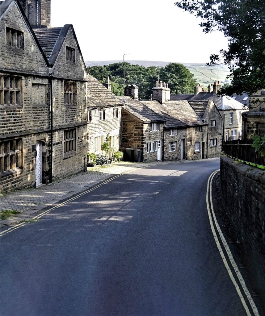
Walk Derbyshire – Viator’s Bridge & The Dove Holes

This short walk can be fitted in with a trip exploring more of Dovedale or simply as a day out combined with lunch at one of the hospitable pubs in villages round and about the valley. It is over 300 years since Izaak Walton fished in the pure waters of the river Dove along with his impecunious friend Charles Cotton of Beresford Hall, near Hartington. Apart from light traffic along the short stretch of modern road through Milldale, the two friends would easily recognise this part of the dale. Dovedale and its famous trout stream have changed little since Walton and Cotton spent time along its banks, angling and philosophising. Walton referred to the Dove as being ‘The finest river that I ever saw and the fullest of fish’; a sentiment true even today. Many of the houses in this tiny hamlet are founded on dwellings that would have been standing in Walton and Cotton’s time. The village takes its name from two mills that once provided employment for people living there; remnants of both mills remain, still capable of taking power from the river. Lode Mill is higher up the valley; converted into a barn, it once ground and separated lead ore from the parent limestone. The mill closest to the village is Ochre Mill; powered by water from the leat which begins a few yards upstream of Viator’s Bridge, is also recognisable as a barn, but in its day it produced powder for making red lead paint. In his angling treatise The Compleat Angler, Izaak Walton refers to himself as ‘Viator’ (traveller), and addresses Cotton as ‘Piscator’. (angler). In the book Walton expresses amazement at the narrowness of the bridge which bears his nom-de-plume, ‘Viator’. The route followed by this walk follows the river downstream from Viator’s Bridge as far as the curious rock formation known as Dove Holes. A secluded dry dale to the left and a few yards prior to the holes, climbs up to Hanson Grange Farm where the walk joins an ancient packhorse way back down to Milldale. The Walk : From the car park walk down to the river and cross narrow Viator’s Bridge. Turn right to follow the riverside path for a little under a mile. The thin alkaline soil on the craggy valley sides, supports many semi-alpine plants such as thyme and dwarf cranesbill. Turn left at the finger post pointing to Alsop-en-le Dale and climb the tree-lined dry dale and go beneath the line of rocky crags known as The Nabs guarding the dale’s exit. Before turning left uphill, walk forwards for about 80yards to visit Dove Holes. These massive water-worn holes appear, at first glance to be the start of an extensive cave system but are, in fact only about 20ft (6m) deep. This is a good vantage point for views up and down the dale. Return to the finger post and turn right to re-join the described walk. Turn left though a stile at the dale head and follow a series of stiles leading to the right of Hanson Grange Farm. Join its exit lane about 100yds (91m) beyond the farm. Hanson Grange Farm. There were several extensive monastic sheep walks in the area, until the Dissolution. Hanson Grange was part of one. The farm house looks Jacobean, but is probably built on older foundations. At the end of the partly walled section of the farm lane, turn left as indicated by a signpost close to an underground reservoir. Follow the sign’s direction across a series of fields, downhill towards Milldale. Zigzag downhill on the ancient packhorse way back into Milldale. The George at nearby Alstonfield is a popular pub for travellers, either by car, on foot, riding or pedalling. The oldest relic in Alstonfield Church is the economically worded inscription on the double decker pulpit which states: ‘Be faithful and etc., and I will give thee a crown etc.’ No doubt the carpenter was in a hurry when he carved those words! Useful Information 2½miles (4km) of valley walking, with one steep climb through woodland beneath The Nabs. Level farm tracks followed by a narrow packhorse track back down to Milldale. Recommended map. Ordnance Survey 1:25,000 scale Outdoor Leisure Sheet 24; The White Peak Area. Car Park. About a quarter mile above the village, west along Hope Dale (free). Refreshments: a cottage in the centre of Milldale serves light refreshments over a half-door. Pubs in several nearby villages. [wpgmza id=”33″] 00
Derbyshire Walk – An Alpine-style walk around Matlock Bath

On a sunny weekend today’s Matlock Bath is popular with middle-aged motorcyclists whose expensive mounts line the riverside frontage. They are just the modern manifestation of the visitors who come to enjoy the local scenery. As far back as the Georgian era, people have come to admire the unique setting of this small village: at first it was only visited by those who could afford the expense of horse-drawn transport, but when the railway came, and with it cheaper transport, it opened up the place for those with lighter purses. Since then the coming of the motor car has spread the net and people flock from all over the north Midlands for a day out in this mini-holiday resort. Early visitors likened Matlock Bath to an alpine resort, and that cannot be far from the truth. Romantic poet Lord Byron described Matlock Bath as; ‘There are places in Derbyshire rivalling Switzerland and Greece’. A bit far fetched, but with the vertical limestone crag of High Tor and its continuing ridge opposite the main part of the village, the aspect is not far removed from some alpine village – admittedly not quite as high, but nevertheless the looks are there. The ambience is continued with the cable car up to the Heights of Abraham and its terraced woodland walks. There’s even a tiny chapel, St John’s, about half way between Matlock and Matlock Bath that could easily be mistaken for a miniature Alpine Schloss. Probably the closest to a truly alpine footpath is the path along what is known as ‘Giddy Edge’. This path, complete with a metal handrail crosses the upper face of High Tor and can truly be compared – again, in a small way, to Via Ferrate the iron ladders that criss-cross the Dolomites and other limestone mountains of the Alps. This walk uses many of the high-level and riverside paths that wander high and low around the village. Starting at Matlock Bath railway station the walk climbs up the side of High Tor into the outskirts of Snitterton. This linear satellite village follows what was once the only road south from Matlock until the line of the A6 was developed. Entering woodland, the path climbs to the summit of High Tor, where the exciting prospect of the Giddy Edge path begins its descent back into Matlock Bath. Here if you want, a truly alpine extension to the walk can be made by taking the cable car to the top of the Heights of Abraham and enjoy its woodland walks. (Visit www.heightsofabraham.com for opening times) Continuing towards the riverside section of the walk, a footpath leaving the car park climbs to the ridge-top continuation of High Tor, before dropping down to the river by a series of well-laid steps. A left turn at the river will follow the wooded path called ‘Lovers’ Walk’ until it reaches a modern footbridge. Over this are the Riverside Gardens and beyond is the Pavilion, the restored replica of an alpine Kursall, or spa. The fascinating Peak District Lead Mining Museum is here together with a friendly café dispensing home-made food. There are many alternatives for refreshments along the roadside, ranging from fish and chips to several excellent restaurants and pubs. A WORD OF CAUTION While the Giddy Edge section of the walk has a well-placed handrail, it should be approached with great care and certainly not in wet or icy conditions. For anyone not wishing to use the Giddy Edge path, there is an alternative route bearing left at the start of the edge path which crosses the highest point of High Tor. Children and dogs must be under close scrutiny at all times. The Walk Take the side road parallel to both the river and railway line, away from the car park. Turn right and go under the railway, uphill towards the entrance to the bottom station of the Heights of Abraham cable car. Do not bear left to the cable car entrance, but continue ahead and through a squeezer stile next to a metal gate. Climb the roughly surfaced track until it reaches an unmade road lined with houses. Turn left on this road and go through a gate opening on to a surfaced track leading into woodland. The track climbs steadily, bearing right in its upper reaches. Where the track on leaving the trees bears left, continue ahead until it peters out. (The track going left is heading for a radio mast). The woodland is part of the High Tor Recreation Grounds. There are several roofless old mines around the summit, often bearing fanciful names such as ‘Fern Cave’ or ‘Roman Cave’, but none are quite so ancient. It was once possible to enter the mines for self-exploration, but an over-cautious council has closed them off on Health and Safety grounds. There was once a café on the summit of High Tor, but it mysteriously burned down within a few days of its closure. Swing round to the left away from the mast compound and make for the summit of High Tor to admire the view. N.B. There is no barrier at the summit, so keep well away from the edge – there is a 190 foot drop straight down the tor face. Bear left away from the summit rocks and follow the signpost towards Giddy Edge, making use of the iron handrails as necessary. N.B. If it’s icy, raining or if you do not have a head for heights, bear left away from the start of the Giddy Edge path and go over the highest point of High Tor. This path joins the Giddy Edge path on the far side of the summit. Continue on the edge path, using a well-placed seat for a rest along the way. At the far end, join a rough path zig-zagging steeply downhill through mature woodland. Go to the left and then right around the perimeter fence of the cable car. Go under the railway bridge and turn left on to