Walk Derbyshire – Riber Via the Front Door

Standing at 850 feet above sea level on an isolated hilltop, Riber Castle, to give it its acknowledged title, has dominated Matlock’s eastern skyline ever since John Smedley built it in 1862. His idea was to make it the de-lux version of the spa hotels springing up around the town, venues of places offering accommodation for those taking part in his ‘water cure’. Visitors from all stations of society came to this attempt to copy a European spa such as Baden Baden in order not simply to drink the waters, but to be subjected to high pressure hosepipes blasted by evil-minded operatives, wielding hoses aimed at various parts of the victim’s anatomy. This rather curious method of health improvement, enjoyed a short-lived popularity until changes in attitude and two world wars brought about its demise. With its departure, Matlock took advantage of the spas. Some became nursing homes and others developed as apartments; the main one found a use as the headquarters of Derbyshire County Council. Smedley first had the idea of his ‘water cure’ when he was in recovery following a nervous breakdown. Part of his cure was time spent at one of the European spas. Feeling much better after the spell of being sluiced by the Germanic system of being mauled with powerful jets of water, he came home with the idea of turning the tiny market town of Matlock into the spa of dreams. Already a successful businessman, owning a garment knitting factory in Lea Mill that still flourishes, he decided to use his captive team of employees as guinea pigs in order to try out his new cure-all ideas. There is no record of his employees’ willingness or otherwise to take part in his experiments, but, as none of them appear to have suffered more than a loss of their dignity, they did at least form the basis of those who came for this so-called cure. Smedley was so successful that his fortunes grew and he was able to encourage his senior management to open subsidiary branches around the town, and even sponsor the building of a cable-hauled tram that climbed Bank Road from Crown Square in the centre of Matlock, conveniently near the railway station serving trains on the London to Manchester main line. All that is left of the long-abandoned cable car, is the slight widening of the street about half way up the hill, where trams could pass; the steam engine powering the cable was housed in the building now used as a car workshop at the top of Bank Road where it joins Wellington Street. He persuaded his senior employees to open satellite establishment. All of those satellites together with the main which is now DCC’s headquarters, have been put to other uses in recent times, ranging from care-homes, to luxury apartments. John Smedley decided to build his main feature Riber Castle, not just as a luxury spa hotel, but as his home. Although the pretentious towers of this mock-citadel act as vantage points for views along the valley and, one must suspect, it was where he could keep an eye on the activities of his workforce in Matlock and Lea, both of which can be clearly seen from Smedley’s eerie. It was to become the major building in a substantial group of medieval buildings which had stood there and in fact still do, since before the 17th century. Unfortunately his plan to build Riber Castle as a super hydro came to nothing, due to one simple yet overlooked fault – the builders couldn’t find sufficient water needed for the complex equipment his plan envisaged. As a result it became where Smedley spent his last days. The place seems to have been dogged by bad luck ever since; it became a minor public school for boys, then during World War 2 large quantities of sugar were stored in rooms where Victorian ladies and gentlemen once took their ease. In more recent times its ruins became a European wildlife zoo, where locally bred European lynx were exported to a Spanish national park. Their transfer was carried out by the RAF, using lynx helicopters! The latest scheme intended to preserve the future of the castle is to develop it as a luxury set of apartments, complete with a helicopter landing pad. Only time will tell if this scheme will be the success its planners envisage. This short walk in the brief but steep climb up to Riber passes through much of Matlock’s history. Starting at the medieval bridge, then moving on past the shelter that once stood at the tram terminus, the walk moves on by way of award winning Hall Leys Park that still holds the ambience needed for gentle exercise, or admiring the flower beds full of colour each summer. Where there was once a cycle race-track, youngsters can enjoy the thrills of the new track. Following jitties through Knowleston Place, the walk passes one of Matlock’s two flour mills now finding fresh uses. The mill stream that once powered their grind-wheels is followed as far as the cluster of buildings at the foot of Lumsdale. Next and after crossing the Alfreton road, a steep path climbs up to Riber’s cluster of medieval stone houses; its castle dominates the view along the Derwent valley, from a glimpse of High Tor’s limestone crags, to Masson Hill across the gorge. The walk leaves this ancient view by dropping steeply down to Starkholmes and then a riverside track will take us back into Hall Leys Park and the centre of Matlock. THE WALK From Crown Square in the centre of Matlock, follow the riverside track through Hall Leys Park as far as the side road beyond the children’s play area. Following Bentley Brook, go past the houses of Old Matlock and turn right along the main road. Cross over at the pedestrian crossing and turn right. Follow the main road, over the turning for Chesterfield and continue as far as the last houses.
Walk Derbyshire – Walking Eyam, Bretton Edge and Foolow
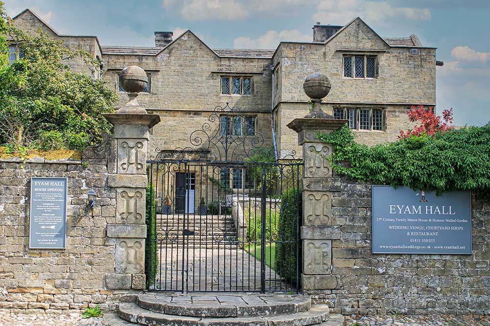
Here is a walk through some of the historical countryside surrounding the plague village of Eyam, a village where the Covid-19 pandemic must have jogged some deep folk memories from a time when the inhabitants of Eyam made a courageous stand against an outbreak far worse than that which beset them in more recent days. The walk starts logically one might say, from the car park directly opposite a small, but fascinating museum devoted to the stand made by those villagers in 1665/6, when led by a far sited young rector, the Reverent William Mompesson and assisted by his friend and predecessor, Puritan minister Thomas Stanley. Simply by what was surely firm and sensible leadership, they managed to persuade the people of Eyam to hold themselves in total isolation, despite more than half their number succumbing to the dreaded virus known as Bubonic Plague. All around Eyam village you can find relics of that terrible experience, from the natural pulpit in Cucklet Dell where Mompesson preached in the open air. Other relics are Mompesson’s Well high above the village on the edge of Eyam Moor where the far sighted vicar aided by the local landowner, the Earl of Devonshire, arranged for kind hearted suppliers to leave essential supplies, paid for by cash left in the purifying waters of the well. Another transfer point is the limestone boulder beside the path leading down to Stoney Middleton. Money dropped into holes filled with vinegar carved in its surface was rendered safe by the purifying action of the vinegar. Along with these exchange points are the number of simple graves dug into places well away from the village church; they were dug by survivors who had the onerous task of burying their nearest and dearest in places ranging from local fields and even gardens. This is a walk that starts by tasking the ability of all those who are prepared to make the steep climb up to the Sir William Hill road, high up on the edge of Eyam Moor. Fortunately this is the one and only climb, and a climb where the effort offers a reward of some of the finest views in the Peakland. Descending from Bretton Edge, the walk passes through Foolow followed by a mile or so of field paths leading all the way back to Eyam. USEFUL INFORMATION 6 miles (9.6km) of moderate walking , beginning with a steep climb from Eyam up a woodland path, followed by open fields leading to moorland road walking, then by a fairly level path across small fields, back into Eyam. Excellent wide-ranging views from Bretton Edge. RECOMMENDED MAP Ordnance Survey 1:25000 scale Explorer Map, Sheet OL24; The Peak District, White Peak Area. PUBLIC TRANSPORT Buses from Bakewell and Sheffield via Grindleford. REFRESHMENTS Eyam village. The Barrel at Bretton and the Bull’s Head in Foolow (open Sat & Sun from 12 noon) CAR PARKING On outskirts of Eyam village, opposite the village museum. Directions : From the car park opposite Eyam Museum, turn left and left again to follow the village’s main street, past the Jacobean hall and then the plague cottages where the dreadful virus first struck. Go through the church gates on your left and follow the path through the graveyard, past the church and then climb out into open fields. (Look out for the amusing memorial stone to a famous county cricketer). Cross the road and climb steeply up the woodland path a few yards uphill from the entrance to Beech Hurst Youth Hostel. Continue steadily uphill across three small fields above the wood, until the path reaches a side lane. (Mompesson’s Well is a little over a quarter of a mile to your right if you wish to make a diversion to this historical place). The walk turns left and crosses the lane for a couple of yards and then turns right to climb over a stone stile in the gritstone boundary wall. Keeping on the left of a boundary wall, climb steadily over Bole Hill which was the site of a small lead smelter for nearby Ladywash Mine. After a quarter of a mile of walking through pasture above Ladywash Mine whose chimney can be seen in trees over to the right, climb over a ladder stile and join the Sir William Hill road. Turn left and walk down the unsurfaced road until it joins a narrow lane at a sharp bend near the start of Bretton Edge. Spend time admiring the wide ranging views, both north and south across the Peak District moors and pastures. Walk along the road for about a hundred yards and then turn right along a descending rough track. The track becomes a narrow surfaced lane servicing the scattered cottages overlooking Bretton Clough. Keep with the lane as it climbs to the left past Bretton hostel in order to reach the ridge-top road once more. It is next to the Barrel Inn. (Food available, both inside the pub and out). Turn right on joining the top road beside the Barrel and begin to walk downhill. After about a quarter of a mile, take the left-hand fork and continue downhill along the road, past a small well and for about three quarters of a mile until it reaches Foolow. (There have never been any people who can be classed as foolish living in and around Foolow. The name actually means Foo’s Hill – Foo would have been the name of an early Saxon settler in these parts). Turn left beside the tiny non-conformist chapel on entering the village and walk past the duck pond overlooked by the village cross on your right and a bull ring almost lost in the grass. With the Bull’s Head pub on your left, follow the Bretton road, bearing left at the fork for about 150 yds. Look out for a stone stile in the wall on your right. Go through the stile and bear left to cross four narrow fields, using stiles in their boundary
Walk Derbyshire – Tegg’s Nose and the Upper Bollin Valley

5 miles (8km) of moderate to strenuous walking on well-defined footpaths and by-roads. 492-foot (150m) descent and ascent. Recommended map: Ordnance Survey 1:25,000 scale, Outdoor Leisure Map Sheet 2, The White Peak. Bus Services: High Peak number 58, hourly on weekdays and two-hourly on Sundays and Bank Holiday Mondays. Car Parking: Pay and Display Tegg’s Nose Country Park Refreshments: Tegg’s Nose Car Park Café and also Leather’s Smithy on the road between Langley and Macclesfield Forest. For this walk we are going over to the western edge of the Peak District, into the Cheshire Highlands. This region unexpectedly is one of the few places where a real peak can be found in the Peak District National Park. The district’s highest point is Shutlingsloe, the 1660 foot (506m) true peak whose graceful slopes can be seen over to the south west of the A537, Buxton to Macclesfield road. The area is quite historical in its way, as discovered for example, when exploring the footpaths on either side of Wildboarclough, one of the many places where the last wild boar was supposed to have been killed. There are several friendly pubs along the way, many of them gaining high renown for the standard of their catering. In fact, Leather’s Smithy the pub half way round this walk has gained several awards and acclaim. Another feature is Forest Chapel just a little way off the route of the walk. This tiny stone moorland place of worship is one of the few places in the British Isles where the floor is spread with fresh rushes on the nearest Sunday to the 12th August each year. The walk just touches a small part of an area better known by walkers and cyclists coming from east Cheshire and Greater Manchester. Having once lived in that area, we developed a love and knowledge of the moors and valleys surrounding Shutlingsloe, and are still tempted back every now and then to renew our memories of times past. This walk is just one of the many we know and have enjoyed. It starts and finishes at Tegg’s Nose Country Park; its car park is accessed from Buxton Old Road – leave the A537 at Walker Barn and turn left (if coming from Buxton) and drive down the old road; Tegg’s Nose Country Park car park is signposted about half a mile further along the narrow road. Tegg was a mythical giant who inhabited these high moors. The name is possibly a corruption of Tegga, a pre-historic local chieftain who was buried on the Naze, or Nose, again a corruption, in time gone-by. Early on in the walk allow time to explore the collection of restored old quarry machinery displayed in the hill-top sandstone quarry. From the quarry the walk follows part of the Gritstone Trail, a long distance footpath from Lyme Park near Stockport to Mow Cop on the outskirts of the Potteries. Dropping into the headwaters of the River Bollin, a left turn at the first of four reservoirs begins the climb back by way of Macclesfield Forest. The mature plantation of pine forest, along with the reservoirs has been claimed by wildlife, ranging from badgers and foxes, to semi-rare water fowl such as crested grebes. THE WALK 1. Leave the car park by walking back towards the road, but do not join it. Turn left along a wide well-made path leading by way of two kissing gates, to the rear of heather-covered quarry spoil heaps. 2. At the second gate, go through it and turn left to climb the stone-flagged steps, uphill. At the top of the climb, pause for breath in order to admire the view by way of Macclesfield Forest to Shutlingsloe and beyond. A nearby outdoor exhibition on the old quarry floor displays a collection of stone-cutting machinery, together with examples of stone walling and masonry techniques. A yellow boot waymark superimposed by a brown letter ‘G’ indicates that the path is part of the Gritstone Trail. 3. Turn left away from the main path and following Gritstone Trail waymarks, go down a flight of stone steps and follow the path steeply through woodland, downhill to Tegg’s Nose Reservoir. 4. Go through a kissing gate and bear right to cross two adjacent dam walls. Turn left on reaching the valley bottom road. 5. Walk along the road as far as Leather’s Smithy pub and then take the left fork in the road. Follow this side road for about a quarter of a mile. 6. At a small car park, turn left through a narrow belt of trees and then bearing right, walk uphill along a forest access track. 7. Follow a set of waymark arrows uphill and into the forest. 8. Turn left at a four-way signpost and go past an old barn. Follow the forest path downhill. 9. Look out for a sign pointing to Walker Barn, low down by a gap in the wall. Turn right here and follow the path uphill until you reach a wall crossed by a stile in order to reach the access lane to Ashtree Top, an old farm now restored as a modern house. 10. Climb over the stile and go diagonally left across the road to another stile on your left of the large house. Cross this and walk down the field, then across the heads of two shallow side valleys. Climb with the path, half right away from the second and furthest valley. Pause at the crest of the last valley and use it as an excuse to admire the view. Tegg’s Nose is in front and slightly to your right, with Langley Reservoirs in the valley bottom. Beyond and to your left is Sutton Common and its strangely adorned telecommunications tower. In the far distance you can probably make out Jodrell Bank telescope as well as Mow Cop further on into Staffordshire. The prominent little hill of Mow Cop is topped by a folly built in the shape of a ruined