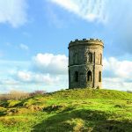
Edit Template

Walks In Derbyshire

There really is no better way to see the beautiful area that we live in than to walk in Derbyshire. Over the years we have walked what feels like pretty much the entire of Derbyshire and Nottinghamshire and feel it only right to share those walks with you. In every edition of Country Images Magazine we feature a walk for you to follow and now we’ve put them online for you to read too. If you have a mobile or tablet, why not follow the walks on it, with a map and an explanation of where to go it’s ideal for you to follow so as not to get lost. We hope  you enjoy the selection below and check back regularly for new walks.

 
  • All Posts
  • Walks
Walk Derbyshire – Three Shires in a Flash

February 23, 2021

Children will love this walk, for where else can they visit three counties within a matter of seconds?  The highlight of the walk is the bridge known as Three Shire Heads, where Staffordshire, Cheshire and Derbyshire all meet at a point in the middle of an ancient pack horse bridge over the River Dane.  To reach it means following moorland tracks radiating from Flash, the highest village in England, although some claim it to be the highest in Britain, backing it with a road sign erected by no less an adjudicator than the Peak District National Park Authority. Winter starts early in Flash and lingers long after spring has arrived in more sheltered places.  The wind is keen but refreshing and the views far ranging.  Counterfeiters once carried out their nefarious trade in remote farmhouses around Flash and its name has since become linked to any suspicious or ‘flashy’ object.  During the first half of the 19th century the population of the parish was around 700; but it had reduced to around half of that by the end of the 1800s, and even less today.  Most of those living there at that time were either agricultural labourers, roughly the same number of coal miners, stone masons, a dressmaker, blacksmiths and cordwainers (shoemaker who used fresh leather), an errand boy, wheelwright, gamekeeper, grocer, pedlar and even a tailor as well as a brewer and a number of house servants.  Following them were 275 young people and 50 scholars.  Not everyone could find regular employment and at one time almost a quarter of the population were drawing relief from the parish.  Most of the village’s working inhabitants commute to Leek and Buxton, or further these days.  Nowadays Flash still has its own little brewery and a small general store attached to the...

Walk Derbyshire – Elton & Gratton Dale

February 15, 2021

This walk explores one of the lesser known parts of the White Peak.  Properties in Elton where the walk starts, would be easily recognised by any returning inhabitant, even after the passage of long forgotten centuries. At one time there were two villages, Gratton as well as Elton, but following an outbreak of the Black Death plague, Gratton was abandoned, eventually reappearing as a scattering of small cattle and sheep farms clustered around a dairy specialising in the production of a unique crumbly white Derbyshire cheese.  Many of the farms in and around Elton were rented by part-timers who divided their above ground activities with small-scale lead mining.  Their activities can still be traced from the numerous spoil heaps and capped-off access shafts dotted around nearby fields. As the price of wool declined in recent years, dairy farming became the major activity, with Oddo House Farm on the west side of Elton running the largest herd.  It is many years since local milk was sent down the hilly lane to Gratton, there to be made into cheese; the abandoned dairy now serves as a well restored domestic dwelling and holiday let. Starting near Elton’s quirky pub, the Duke of York, the walk follows a field path which skirts an abandoned Saltway between Ashbourne and Bakewell.  It was diverted eastwards when Elton Common was enclosed.  Ancient footpaths lead to the mother church in Youlgreave, but the oldest track by far is the Portway about half way between Elton and Winster.   Prehistoric in origin, it can still be traced locally where it crosses the valley of Ivy Brook below Birchover; aiming for the crags of Robin Hood’s Stride, it passes a hermit’s cave marked by a simple crucifix carved into the rocky shelter, the path continuing below on its long way...

September 23, 2020

Distance: 10.3 miles of easy road walking, mostly through woodland followed by a gravel track above Howden and Derwent Reservoirs. Recommended Map: Ordnance Survey Outdoor Leisure Series Sheet1; The Peak District, Dark Peak Area Public Transport: Hulleys and TM Travel 273, 274 & 275 Two Hour Service from Bakewell and Sheffield via Castleton and Bamford. Car Parking: Fairholmes Visitor Centre.  N.B. Please note that the valley road is open to walkers, cyclists and horse riders, but it is closed to cars and motor cycles on Sundays and Bank Holidays from Easter to end October.  Bus service from Bakewell, Sheffield via Castleton and Bamford (railway station). Refreshments: Fairholmes Visitor Centre. Although man-made, the flooded section of the Derwent Valley can vie with most of the English Lake District.  Three reservoirs built over fifty years during the early to mid-twentieth century, have mellowed into an attractive amenity for all users. Trees planted at the same time as the reservoirs were built, have now matured and generally being of mixed varieties, make a perfect foil to a remote scene composed of water backed by wild moorland. Starting with Howden at the upper section of the valley, each dam and ancillary features such as culverts and filter beds, were built individually, one after the other gradually moving downstream.  In order to accommodate the over a thousand-strong workforce, a village of corrugated iron huts was erected, catering for every need from groceries, to a doctor’s surgery and a barber’s shop.  The village was known officially as Birchinlee, but soon found its way into the vernacular as ‘Tin Town’. The walk passes the site of Tin Town.  Nothing remains of the actual buildings, but overgrown terraced ledges still mark the street pattern.  A roadside plaque tells the story of a village that disappeared once its purpose...

Walk Derbyshire – Into The Past Through Five Historic Sites

August 25, 2020

History is everywhere with us in the Peak District.  People have lived on and shaped the land for thousands of years, from the erectors of prehistoric standing stones and henges, right down to the current developments needed to house today’s expanding population. This walk touches a sample of five different ways the Peak has been affected throughout the centuries, each one leaving its mark as time moves on.  The walk starts and finishes at Monyash, a small village on the limestone uplands, where farming is still the major occupation of many of its residents.  Their predecessors left their mark when, in the eighteenth century, the Enclosure Acts allowed landowners to define field patterns, creating a maze of dry-stone walls typifying the Derbyshire landscape to this day.  The next relic will probably be unnoticed, but the Roman road from Derby to Buxton will be crossed twice along the way.  After crossing this road and its modern equivalent, the A515, a footpath drops down to the High Peak Trail, a walking and cycling track following part of the abandoned railway from Cromford to Buxton.  Next comes the highlight of the walk, Arbor Low.  Here is a stone circle built by our neolithic ancestors around 5,000 years ago, once the land became usable after the end of the Ice Age.   Finally, the modern dairy and sheep farm at One Ash Grange started life as a monastic penitencery for recalcitrant monks from Roche Abbey near Rotherham. Alongside these five historical features, prehistoric burial mounds and capped lead mine shafts scattered around the fields were left by our recent ancestors, each and every one as well as us, leaving theirs and our mark on the landscape for good or bad. The walk is suitable for all weathers, and has gentle gradients throughout.  At the...

Walk Derbyshire – Holymoorside

March 27, 2020

DISTANCE: 3½miles (5.6km) of easy walking along farm lanes and woodland, plus by-roads and side lanes. RECOMMENDED MAP: Ordnance Survey 1:25000 scale Explorer Map, Sheet 269, Chesterfield & Alfreton. PUBLIC TRANSPORT:  Stagecoach X17 from Matlock. CAR PARKING: Roadside on Belland Lane, connecting the A632 Matlock/Chesterfield road to the B5057 Darley Dale /Two Dales road. REFRESHMENTS: Bull’s Head in Holymoorside and Peak Edge Hotel near Stone Edge.  High fields Farm Shop and Restaurant about a quarter of a mile to the west (Darley Dale Side) of Belland Lane is highly recommended.  This short walk visits Holymoorside, one of Chesterfield’s satellites, a little bit of rural attachment left behind when the Industrial Revolution swept across the north Midlands.   Apart from a street name, nothing remains of the one cotton mill that was powered by water from what is now the local duck pond.  There was even a short-lived silver mine, but this failed a long time ago.  What we do have from time gone by, are a couple of strategically placed pubs and a popular farm café, all within striking distance of the walk, whether it be at the start, or around the half-way point. Holymoorside village lies below the eastern edge of Beeley moor.  The village has many tales associated with its isolation.  Local legend has it that there is a tunnel from Chander Hill Farm just off the Chatsworth Road, passing under Holy Moor to reach Harewood Grange, once a monastic farm.  Despite all these myths and legends, there has never been an explanation of the term Holy Moor, or Holymoorside. There are two ways to start the walk, the first and the main one described in the text, starts and finishes on Belland Lane just off the Darley Dale road near Stone Edge.  The alternative uses public transport;...

Walk Derbyshire – Miller’s Dale

February 25, 2020

DISTANCE: 5 miles (8km) of field and river path walking linked by a mile of walled farm track.  Reasonably dry underfoot except during lengthy wet spells. RECOMMENDED MAP: Ordnance Survey1:25,000 scale Outdoor Leisure Series Sheet 24, White Peak area. PUBLIC TRANSPORT:  TM Travel service 65 between Sheffield, Miller’s Dale and Buxton, hourly service, Monday to Sunday.  G&J Holmes/Hulley’s Buxton/ Miller’s Dale service 66.  Monday to Sunday. CAR PARKING: Station yard – pay and display.  Toilets on station platform. REFRESHMENTS: Station waiting room on platform.  This walk starts and finishes at the Monsal Trail car park on the site of the old Miller’s Dale Station.  Considering the fact that it appears at first glance to be only serving a scattered rural community, what was the need for such a large station?  The answer lies in the fact that it served two railways, the mainline from London St Pancras to Manchester and the Buxton branch line.  Both lines were closed in 1968 following Doctor Beeching’s notorious report.  Realising that the mainline passed through some of the finest dale-scenery in Derbyshire, Peak District National Park acquired the section of track between Bakewell and Wyedale, creating the popular Monsal Trail, an all weathers trail for walkers, cyclists and horse riders.  A café was opened in what was once the station waiting room, which together with the adjacent car park, made it an ideal starting point for walks along the trail and on the network of surrounding footpaths. I must have inadvertently travelled on one of the last trains to call at Miller’s Dale Station in 1968.  I had an appointment in Leicester on what turned out to be a densely foggy day, so as I lived at the time, conveniently near the Buxton/Manchester line, I decided to travel by train.  Returning later in the...

Load More

End of Content.

We hope you enjoy the walks, but check back regularly for more walks in Derbyshire and walks in The Peak District as we are constantly adding new ones.

Country Images Magazine

Featured Posts

Euromedia Associates Ltd

Country Images Magazine is Derbyshire’s leading independent lifestyle magazine, proudly rooted in the heart of the county and dedicated to celebrating its rich heritage, natural beauty, and vibrant communities. Each issue features a carefully curated selection of articles exploring Derbyshire’s history and landscapes, alongside the latest home and interior design trends, local theatre productions, cultural events, dining destinations, and lifestyle inspiration.

In addition, Country Images provides a trusted platform for showcasing independent local businesses, highlighting those that offer outstanding products, personalised service, and a genuine commitment to quality. Through thoughtful editorial and strong community connections, the magazine continues to inform, inspire, and connect readers across Derbyshire.

Euromedia Associates Ltd Logo