Bowes Museum – Barnard Castle
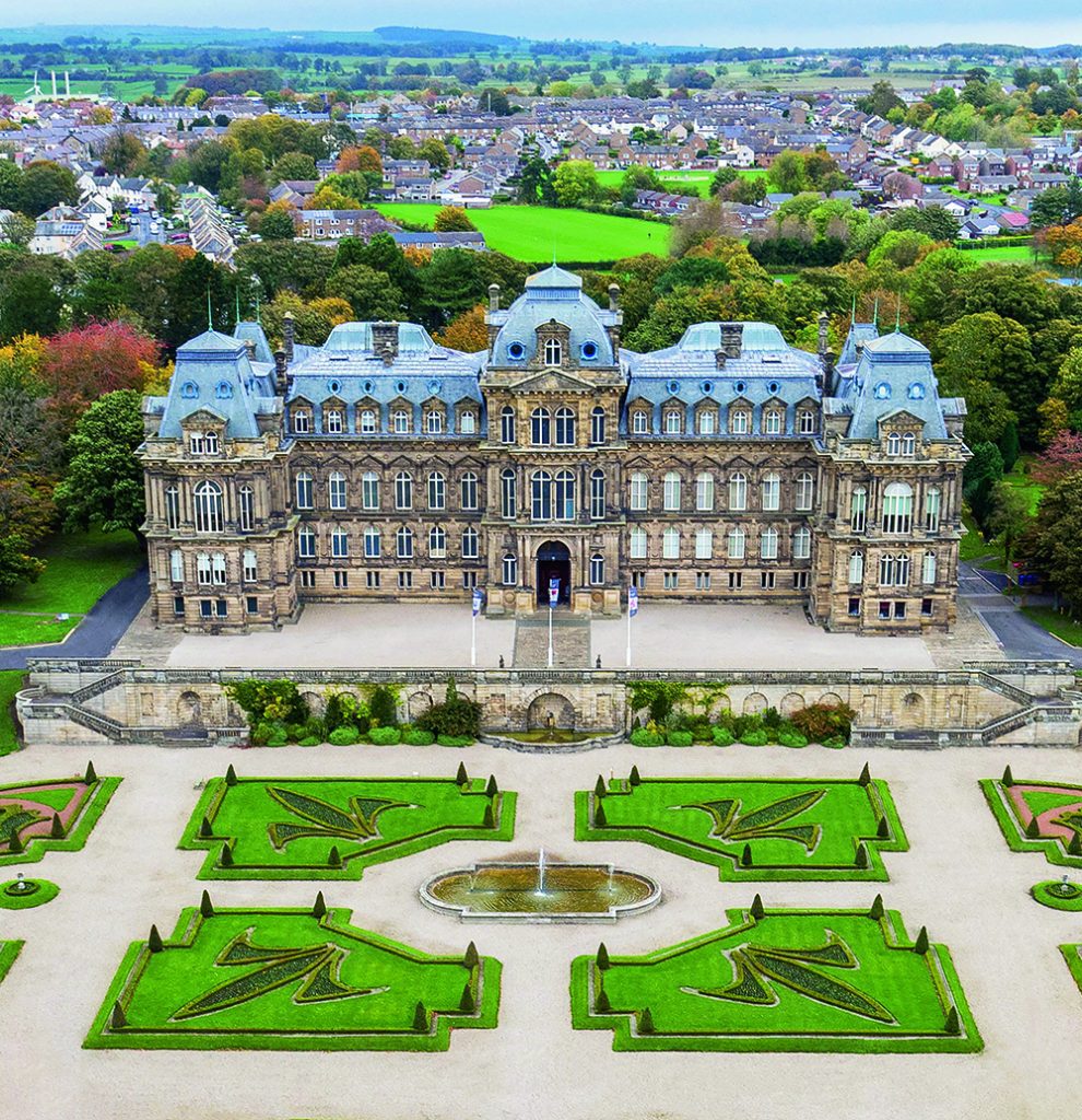
When Dominic Cummings, Prime Minister Boris Johnson MP’s political aid made his controversial dash to Specsavers in Barnard Castle, it is doubtful he had the time to visit the Bowes Museum. This was a pity, because it is nearby, on the outskirts of the town. If he had managed the short diversion away from the town centre, he and his family would have been rewarded by a trip round what is arguably Britain’s most unique museum. It is not simply the collections of treasures within Bowes Museum that is the attraction. The result of a lifetime’s collection by a philanthropist couple, it is it’s venue that first hits the senses, making jaws drop and eyes widen. The reason? No matter how well prepared visitors might be, here in the heart of the Durham countryside is a French château. It was built for John and Joséphine Bowes in order to display a lifetime’s varied collection of European fine and decorative arts. John Bowes was a wealthy landowner with coal mining and shipping interests – through family connections he was an ancestor of the late Queen Elizabeth, the Queen Mother. His French wife Joséphine also inherited wealth. A talented amateur artist, she became a moderately successful actress on the French stage. From all accounts the relationship was a happy one, despite their inability to produce a family, probably due to John Bowes catching a venereal disease during one of his European journeys. Even though their individually accrued wealth suggested an introduction into high society, Joséphine’s Bohemian background did not meet the snobbish Victorian standards of the day. Such was their joint affection that they were able to ignore this snub allowing them to devote their energies by increasing a joint art collection along with planning a suitable home for it. Together they worked tirelessly, developing their unlikely plan to open a French-style, purpose-built museum in rural Teesdale. Sadly both died before it was opened in 1892, but were buried in the museum garden. A collection which John started in his youthful travels around Europe grew steadily, so much so that he had to employ a team of specialist agents to scour major exhibitions. His working relationship with his agents grew on mutual trust, especially when he accepted their suggestion to move on to the work of up and coming artists. This seems to have worked and as a result, the galleries at Bowes now hold paintings ranging from 17th century Dutch and Flemish masters to Impressionists and English landscape masters like J.M.W. Turner, a policy continued by recent purchases of modernistic works. One of the results of this policy based on mutual trust was that many paintings now worth hundreds of thousands of pounds, were frequently bought for as little as £10. Although their purchase price is uncertain, two large paintings by the Venetian artist Canaletto were bought this way. They are displayed alongside works by el Greco and Francisco Goya, just a selection of the famous artists whose work adorns the walls of Bowes Museum. Paintings by Joséphine Bowes mingle at Bowes Museum along with those by better known artists, but they can claim to be there by their own quality and not simply due to her influence. Joséphine worked tirelessly alongside her husband, each keeping to the idea of building a museum in England where anyone could enjoy the results of the Bowes couple’s ambition. For a time the collection was held in the Château du Barry near Louveciennes west of Paris, the one-time home of the mistress of Louis XV, which John Bowes gave to Joséphine as a wedding gift. During the Second Revolution (les Miserables is set in this era), an attempt was made to use the château as a store for military equipment. Concerned about the safety of his prized collection, John Bowes managed to pay off the authorities. A French architect who specialised in designing museums was employed to design the building housing the Bowes collection. It was planned to build on the site outside Barnard Castle, but unfortunately for the Bowes couple, although comparatively small the site was divided into several small parcels, each owned by a separate person. John must have had almost bottomless pockets, for after extensive negotiations, he managed to start building his dream museum. As Joséphine did not relish the thought of crossing the Channel, she kept her visits to England to the bare minimum. However, she braved the hazardous journey and arrived in Barnard Castle in time to lay the foundation stone, and turning to her husband, said ‘I lay the foundation of our dream. You John, will lay the cap stone’. Three stories high and built of locally quarried sandstone, building Bowes Museum, more château than municipal began in 1869 and, costing around £100,000 (equivalent to £9.3 million in today’s money), was ready to receive its valuable collection by 1892. Far sighted as well as being a philanthropist, John Bowes left a substantial legacy to help with the future running of the museum; but by dying comparatively young, this was something neither of the Bowes could predict, and what is there is for all to enjoy. In the heart of rural County Durham there now stands a light and airy building housing a well-run museum and art gallery, open for all to enjoy. Entering through the imposing wrought iron gates, visitors can wander past the well-kept parterre garden, onward to the steps climbing to this unexpected addition to the local countryside. To the left of the main doors, a heraldic shield with three archer’s bows makes a pun on the name Bowes. The ground floor is divided, on the right, the reception and shop area, then, to the left two rooms, one for toys enjoyed by children in Victorian times, the other a small area given over to prehistoric items such as an urn found in a neolithic grave, or enigmatic cup and ring stones. Alongside these curios is a Penny Farthing bicycle and of all things, a
Celebrity Interview – Jenna Russell

She’s a regular in the West End where she won one of the most prestigious awards in showbiz, she’s worked on Broadway and she took over as one of the main characters in the BBC soap EastEnders. Now Jenna Russell is coming to Nottingham. The actress and singer will play French cabaret performer and chanteuse Edith Piaf in Pam Gems’ play with music Piaf at Nottingham Playhouse next month. When the playwright came up with the work in 1973, it was shelved because she was told the central role “needed a strong singer and a dramatic actress in one”. Since then Jane Lapotaire, Elaine Page and Imelda Staunton who played Piaf at Nottingham Playhouse in 1981 have risen to the challenge of taking on the role. So can Jenna pull it off too? “We’ll see! I’d like to think I can. I’ve always loved being in things where I can sing but the character is more important than making a beautiful sound. “Something like Piaf is a great opportunity to inhabit an amazing character and go through the highs and lows dramatically with her and also get to sing. It’s a play with a lot of music but it’s Piaf’s voice we hear.” Speaking from her home just outside Canterbury, Jenna comes over as warm, upbeat and passionate about theatre. She’s relishing the thought of returning to the stage after more than a year now that coronavirus restrictions are being lifted. She’ll be performing what she says is a dream part: “It’s not often you get those roles where the character is so front and centre. They scare the living bejeebers out of you because there’s no time off really and they’re a big ask. “But once you’ve done all the hard work in rehearsals and once you’ve learned the beast and tamed it, they’re the best jobs to do because you have that joy of walking out on stage and knowing you’re going on this journey with the audience for the next two-and-a-half hours and guiding them through this extraordinary woman’s life.” Nottingham Playhouse artistic director Adam Penford met Jenna when he was working at the National Theatre. In 2011 Jenna appeared in Alan Ayckbourn’s Season’s Greetings at the National and the pair became friends. A few years later they met again over lunch and Penford said he wanted her to play Edith Piaf at the Playhouse. “I’d loved working with him and told myself ‘he’s one to watch’. He’s doing such a brilliant job at Nottingham and he’s been amazing in the pandemic, trying to keep the arts alive in the area,” says Jenna. Piaf will be the first major production when the Playhouse reopens. Another reason for Jenna to accept the role is that she will be reunited with Sally Ann Triplett. They’ve been friends since they were 20 and will be performing together for the first time since they appeared in Sondheim’s Follies in the West End 30 years ago. Sally played Judy Garland in Amanda Whittington’s play My Judy Garland Life at Nottingham Playhouse in 2014. For the past few years Sally has been working in New York but has returned to Britain permanently. Jenna says it’s “brilliant” that Sally will also be in Piaf: “She’s an amazing actress and extraordinary singer. How lovely to get to go back on stage in that gorgeous theatre with your best pal by your side. “It’s going to be such a lovely way to go back to the job I love so much and she loves so much. We’re really excited about that.” Lockdown meant that Jenna whose partner is the actor Raymond Coulthard was able to spend more time with her 12-year-old daughter. But now Jenna is itching to get back on stage. “It’s been tough but I think it’s been tough for everyone, hasn’t it? Literally overnight I lost a year-and-a-half’s worth of work. I was in a very lucky position of having three big theatre jobs lined up which is unheard of in my line of work, so it’s a shame that only one of those, Piaf, has come back. “Fingers crossed, we can keep slowly moving forward and get some more work and be able to do what we love doing.” Jenna Russell was born on 5th October 1967 in London but grew up in Dundee. Her career began as an understudy in Les Misérables and later she took over the role of Fantine. She had a stratospheric rise after that, playing the Floor Manager in a couple of episodes of Doctor Who before appearing in the West End revival of Stephen Sondheim’s Sunday In The Park With George. That earned her the 2007 Olivier Award for best actress in a musical. The following year Sunday In The Park With George went to Broadway, with Jenna being nominated for a Tony Award for her performance. She says that was an “extraordinary” time: “I’d been trying very hard for years to get pregnant and had no joy. I did actually manage with IVF to get pregnant when I was in New York. So that whole time is very special. “I was also doing Sondheim who’s my all-time favourite composer and my biggest inspiration as an actor. I was lucky. Every now and then a little bit of magic happens and that was Sunday In The Park With George. It transcended all expectations.” Many people remember Jenna for taking over from Susan Tully as Michelle Fowler in EastEnders. She stayed for 16 months before leaving to pursue other work. She slips into a Cockney accent as she remembers that show. “It was good fun. It was hard work. The scheduling on that show is so full-on and it’s very hard to keep up with friendships when you’re working 12 hours a day, then you’ve got four hours of travel on top of that, and then you’ve got 17 pages of dialogue to learn that night for the next day. “I did enjoy it but I missed theatre
Lost Houses of Derbyshire – Field House, Spondon

Those familiar with the local photographic collections will perhaps be familiar with a photograph of this lost house’s south front labelled ‘Spondon Hall’ and this indeed, is a title to which Field House was attached from time to time, too. In its decline, however, it had become derelict, a natural playground for adventurous children (before an obsession with health and safety curtailed most of the riskier pleasures of childhood). It was locally known a Devas’s, and pronounced ‘deVASSes’ (instead of ‘Deevas’, as is correct) as the late W. H. Brighouse informed me. The house in my photographs was not, however, the first on the site, which appears to have had a long history. The land would seem to have belonged to a farming family called Soar, who appear to have become freeholders. Ellen, a co-heiress, married in 1687 Isaac Osborne of Alvaston (1688-1738), also a farmer. His ancestors came from Elvaston, where lived the earliest traceable forebear, William, an Elizabethan yeoman farmer and tenant of the Stanhopes. Ellen died having had three sons, whereupon Isaac re-married in 1693, Elizabeth, daughter of William Leaper of Osmaston by whom he had another son and a daughter. He became very prosperous, and is thought to have been the builder of the first house on the site, which I assume was a substantial farmhouse. His great grandson, another Isaac (1745-1796) was a London merchant who later was appointed a governor of the Bank of England. He retired to Spondon House (on which see Country Images Lost Houses for April 2018) as his next brother’s third son William was then living at Field house, which he had inherited from his father, the local butcher, in 1784. As a third son, he would not normally have inherited the family home, but both his elder brothers had made lives for themselves elsewhere, Jacob as a wool broker in Basinghall Street, London and Isaac in Georgswalde in Bohemia (now Czech Republic) having married the daughter of a mediatised Count of the Holy Roman Empire, Carolina von Salm zu Schlukenau. Thus it was that this William in 1818 sold the house and went to live elsewhere in the parish, dying unmarried in 1835. The purchaser of house and about 25 acres of land was Bryan Thomas, the second son of John Balguy of Duffield Park (pronounced ‘bawgy’), he was a descendant of the Bulguys of Derwent Hall, who had become an Alfreton coal-owner but who professionally was a barrister and a very eminent judge. Bryan Thomas Balguy (1785-1857) was also a barrister, and in 1818 was appointed Town Clerk of Derby, which is why he needed a house within striking distance of the Guildhall. The house he built was very much up-to-the-minute architecturally, being of two storeys, and with its entrance and main façade facing south west. This side was embellished by a pair of full height round bays topped with conical roofs and lit by wide tripartite windows with Neo-Classical friezes over them and the central bay was embellished by a Doric portico. The nearest equivalent was the west front of Egginton Hall, which was done in very similar style, albeit designed by Samuel Wyatt 38 years earlier. The height of the cornice above the first floor windows suggests that part of the house had an extra half-storey worked in, probably over the service accommodation as was common for local Regency villas. The side elevations were perfectly plain, and the house looked out onto 13 acres of carefully landscaped parkland. The drive from Church Road was what is now Park Road; what the owner of Prospect House, built a little earlier, thought of its proximity to his north side, I don’t know; he cannot have been that pleased. Having built his house, Balguy decided, about twenty years later, to move to Ockbrook Manor (another lost house—watch this space!). He let Field House to William Legh Clowes (1781-1862), a Lancashire cotton magnate who inherited Broughton Hall, in Lancashire, but who moved to Derbyshire on his marriage to the daughter of Revd. Robert Holden of Aston Hall and initially built Stoney Cross House for them to live in. Having moved to Field House however, Stoney Cross was sold. Later, in 1857, when Balguy died, Holden bought the house and park for his daughter and her husband to live in. Meanwhile, their eldest son, Samuel followed his father south, buying the Norbury estate from the FitzHerberts in 1881. Nevertheless, the death of his father obliged William to move back to Lancashire, and Field House was again let, this time to Frederick Arkwright (1806-1874) who, by 1864 was calling the house The Hall, which was confusing, because the Richardson family’s stuccoed villa further down the hillside was also Spondon Hall (see Country Images Lost House August 2016). Nevertheless, his father, Peter, died two years later and Frederick inherited Willersley Castle to which he retired. This left the freehold with Robert Holden’s son Edward, of Aston Hall, whose daughter, Anne Shuttleworth, had married Horace Devas (1826-1903) the younger son of Thomas, a London businessman living at Dulwich in 1857. The family, which believes itself to be of Hugenot extraction, was from Cawood in Yorkshire. Horace Devas was an executor of the will of Edward Holden, from which it is confirmed that the house and grounds were bestowed upon his wife by his father-in-law. Anne subsequently set up home there with Horace in 1866 – hence the colloquial local name for the place. When Horace died, their barrister son, Edward Thomas Devas JP inherited, but he died only a year later, aged only 45, although his mother remained in the house until her death in 1924. One innovation during the Devas years was the transfer to the west end of Park Road, of the magnificent stone gatepiers, formerly pedestrian entrances to St Mary’s Gate House in Derby, designed by James Gibbs. This did not include the actual iron gates themselves, which were put into storage and later re-erected in Derby Cathedral. Quite why
St Kilda – An Enchanting Island In The West

A few years ago while I was exploring the Hebrides, I stood on top of a small west facing hill. The weather was unusually calm and sunny, with a low mist skimming the sea. As I gazed out over the Atlantic, a sudden clearing in the mist revealed what I can only describe as a fairy king’s castle. Peak upon peak seemed to rise from the sea, seeming to float on the air. This could only be the mythical island of St Kilda and its sea stacks that rise from the depths of the ocean to offer breeding space for countless sea birds. Then and there I vowed that one day I would reach uninhabited St Kilda, a vow I have twice managed, once on a fortnight’s National Trust for Scotland working party, and once on a day trip in a small boat from Harris. This account is mainly based on the latter. Gradually a group of shattered peaks rose from the sea ahead of us as we butted our way through the ten-foot high north Atlantic swell. The day was perfect for a trip which started an hour or so before from Leverburgh at the southern end of the Hebridean island of Harris. We were travelling on Orca II, a state of the art boat capable of 29knotts, but then cruising at a steady 19knotts to help make life a little more bearable for those in our group of twelve who were already suffering from ‘mal de mer’. Overhead the cloudless sky was cerulean blue, while at sea-level a light mist added to the mystery of our destination. Eventually the peaks resolved themselves into a group of sea-stacks, rocks reaching almost a thousand feet directly from the sea, and on whose ledges tens of thousands of gannets, fulmars, kittiwakes and guillemots make their precarious nests, while tiny shearwaters and petrels who fish far out on the edge of the Continental Shelf make their nests in burrows alongside clown-like puffins whose tiny wings are more suited to swimming beneath the waves. We sailed into the sparse shelter of Village Bay to land on Hirta, the main island, passing the tiny outlying island of Boreray and its attendant Stac Lee and the highest sea stack in Britain, Stac an Armin (average height above sea level 662ft). Swarming with birds and covered by centuries of their guano, landing on any of them seems impossible, especially when one learns that St Kildans frequently visited them to catch sea birds, the islanders’ staple diet. The story of a group stranded on Stac an Armin for several months when an epidemic broke out in their absence borders on the edge of incredulity. Disembarking for us was not without its excitement, climbing down into the pitching dinghy that took us on to the island’s tiny jetty. Uninhabited except for a small permanent garrison of army technicians manning the radar station which monitors test rockets fired from the island of Benbecula to the east and snooping Russian spy ships; the island’s summer population is increased by a Nature Conservancy Warden and N.T.S working parties. A haven for wildlife, the archipelago of St Kilda is all that remains of a volcanic complex erupting millions of years ago. Its oceanic isolation and the fact that it was not covered by the ice-sheet which smothered most of the rest of Britain make it unique among the Hebridean islands. Classed as a National Nature Reserve, along with the thousands of sea birds, it supports a distinctly unique wren and field mouse. Scraggy Soay sheep which roam over Hirta and some of the larger outlying stacks are a primitive breed that has probably existed for many hundreds – perhaps thousands of years. Minerals in the soil and the moist Atlantic winds dictate the low growing plant species, modified by wind, grazing, and salt spray in winter and huge quantities of bird droppings. Not only are the flowering plants of interest to botanists, but the fungi and lichens are also important. In summer the cliffs are alive with immense teeming colonies of breeding sea-birds, and the gannetry on Boreray is the largest in the world. No one knows when the first people settled here, but there is history in every stone: some structures date from the Stone Age while others are probably from Dark Age, Viking or Medieval periods. It can be said with reasonable certainty that humans lived on St Kilda continuously over the past thousand years, and probably much longer. For centuries a small community existed here, isolated from the outside world but almost as well adapted to its environment as the seabirds forming a major part of their diet. Where the title of St Kilda came from is unknown, for while there are archaeological relics of early missionaries’ cells and the Irish St Brendan the Navigator’s saga speaks of a visit to the ‘Island of Birds’, there is no record of anyone by the name of St Kilda ever living here. The first thing confronting a visitor is the group of army buildings that sit uncomfortably next to the old chapel, school room and factor’s house. Aware of its intrusion, the military does try to help keep the purity of the island intact and visiting N.T.S working parties can enjoy hot showers. Supplies of perishable food is also stored in the army’s massive refrigerators. Beyond this complex is the real St Kilda, a long row of mostly single-storied cottages at right-angles to earlier ‘blackhouses’, the primitive single-windowed and skin-doored, turf-roofed cottages that once provided accommodation throughout the Highlands and Islands of Scotland. The houses date from the 1860s, replacing the blackhouses and were once the most modern houses in the Western Isles. Six of these have been re-roofed to provide simple accommodation for visiting working parties. Organised on the crofting system, each house had its own strip of surprisingly good land running down to the sea, while behind the ‘street’, further ‘quality’ land was
Walk Derbyshire – Combs Reservoir

Combs Moss is an outlier of the higher moors of the Daark Peak. It sits between Buxton and Chapel-en-le-Frith, mainly overlooking the latter. Looking upwards from Chapel, a long escarpment dominates the skyline, marked by two protruding side ridges radiating from its eastern edge. The further of the two, between Combs and Short Edges, is the site of a pre-historic fortress. Using the steep drop on its northern side a double defensive series of ditches at its back, made it an almost impregnable outpost. Using the steep slope of the escarpment, enemy attackers coming from the north would be seen long before they reached the difficult slope rising beneath the fort. With rough moorland slowing attackers from the south and east, whoever held the fortress would have plenty of time to prepare themselves from anyone wanting to use surprise in their favour. Combs is an anglicised version of the Welsh word ‘cwm’, meaning a mountain hollow. This hollow became an ideal place to build a reservoir supplying water for the Peak Forest Canal, the northern arm of a canal network linking Trent and Derwent Valley waterways to the North West by way of a railway across the dry limestone countryside of the White Peak. Peak Forest Canal runs west from Whaley Bridge joining the north western network at Marple where it links the industrial Midlands with Lancashire. I have a special interest in this walk around the upper reaches of the Combs Valley. During my first camp with a scout troop, we pitched our tents in a farmer’s field just outside Combs village. One of our walks followed a rough path up on to the escarpment, the route following one of the side streams. The sight of what seemed endless miles of rough moorland stretching south when we crested the escarpment lip has never left me, and I am sure it formed the start of my love of wild places and high mountains. The walk starts and ends at the car park below Combs Reservoir, a popular sailing spot. Next it follows the reservoir’s western bank to its end before turning along a country lane into Combs village and its friendly Beehive Inn. A winding field track climbs up to a point close to Chapel-en-le-Frith station, before dropping down to Chapel Golf Course and the side of the main road back to the car park. USEFUL INFORMATION 3 miles (4.8km) of frequently rough waterside paths and across fields. Maximum ascent 164ft (50m). Many stiles in field boundaries. Muddy after rain. RECOMMENDED MAP Ordnance Survey 1:25,000 scale, Sheet OL24; White Peak Area. PUBLIC TRANSPORT Bus services and trains from Buxton. CAR PARKING Car Park below Combs Reservoir dam. REFRESHMENTS Beehive Inn at the centre of Combs village and the Gate Inn on the village access road junction with the B5470. THE WALK From the car park below Combs Reservoir, and keeping the reservoir on your left, follow the path climbing beside the dam and turn left to follow the western bank of Combs Reservoir. Follow the course of Meveril Brook as it runs parallel to the reservoir. Ignore the first footbridge on your right after a little under half a mile. At the four-way path junction at the narrow far end of the reservoir, turn sharp right, go over the footbridge beside the path junction and cross to follow a field path. Go under the railway bridge and then follow the path up to a minor country lane. Turn left along this lane which leads directly into Combs village. Bear left beyond the Beehive Inn, then follow a side lane for about 100yards until it joins another lane, signposted to Dove Holes and again bearing left. Turn left and climb this lane for a little over a quarter of a mile as far as Rye Flatt Farm. Turn left opposite the farm, on to a field path winding its way around the curving hillside. Take the left hand path after a little over 200 yards. Keeping beneath the access drive to The Lodge, which will be on your right, follow the path as it descends towards the railway. Join the access drive away from The Lodge (a one-time sporting retreat). Go under the railway bridge and follow the Lodge drive downhill as far as Down Lea Farm. N.B. Many of the footpaths on the next half mile have a reputation for being some of the muddiest in the district, especially after a prolonged period of rain. About 100 yards beyond the farm look out for a footpath on your left. Join this and walk towards Marsh Hall Farm, about a quarter of a mile distant. Bear right away from the farm for about 120 yards as far as a footpath junction where you should take the path bearing left. Walk downstream above a deep-cut stream and then in a couple of hundred yards and at the next footpath junction, bear right to cross the golf course. Take care to follow the waymarks across the links. Reaching the road, the B5470 turn left and using the pavement on the far side, follow past the road junction for Combs village. Continue along the main road towards the dam end of the reservoir, cross over and then turn left for the car park. For anyone relying on public transport, there is a bus stop close to the junction with the village road. There is another pub, the Hanging Gate on the opposite side of the road, conveniently close to the end of the walk. 00
Walk Derbyshire – Thorpe Cloud

Two prominent hills guard the southern entrance to Dovedale; bulky Bunster rises to the west at the end of a broad limestone ridge, while Thorpe Cloud’s graceful summit looks to the east. The steeper of the two, the Cloud has footpaths on three sides and as such has become a popular venue for walkers looking for a short exciting scramble. Alternatively it makes the centre piece of a little known walk linking the Dove and Manifold Rivers close by their junction. This walk begins at the Dove Dale car park, before moving along a short road through the tight gap between the Dove’s guardian hills. At the road end (it is really there to guide anglers to the start of their beat), the famous Stepping Stones take walkers over to the opposite bank. An alternate crossing can be made if the river is in flood, by using the wooden footbridge closer to the car park. If we were to continue to explore upstream along the path over the high rock we come to the place where an eloping parson came to grief a couple of centuries ago. From the stepping stones, this walk turns right to pass round Thorpe Cloud’s lower slopes, by climbing broad Lin Dale. A grassy track reaches the Ilam road next to a public toilet. Thorpe village dots the far side beyond the main road and the walk then follows a series of quiet back roads, past the village church, before dropping down to Coldwall Bridge over the lower reaches of the Dove. Nine out of ten visitors ignoring Thorpe’s charm fail to realise that its foundations date from at least Norman times, but all that is left from that time is the unaltered tower of its church. A wide track drops down to the river, here rather incongruously crossed by a wide stone-arched bridge. This is Coldwall Bridge, nowadays used only by walkers and the occasional farmer on his tractor. Hard to believe, but the bridge once carried an important road, the turnpike between Staffordshire’s Cheadle and Chesterfield, a road that was abandoned almost as soon as it was opened. From the far Staffordshire end of the bridge, a riverside path leads down to the river bank which is followed upstream past the confluence of the Dove and Manifold rivers all the way into Ilam village. Ilam’s Hansel and Gretel cottages originally provided homes for estate workers on the local estate. Ilam Hall home of their lord and master is now a youth hostel based in the property owned by the National Trust. These original owners were the Watts-Russells shipping magnates, the first of whom, Jesse Watts-Russell commissioned George Gilbert Scott, the famous Victorian architect to design a mansion competing with the Earl of Shrewsbury’s Alton Towers. His grand ideas were only enjoyed by two generations of the family, but they had left their mark on this corner of the Peak. The mock –Eleanor cross at the road junction was erected by Jesse Watts-Russell in memory of his first wife, who if folk memory is correct, was not over popular amongst the local tenantry. A much more revered settler in the quiet hollow where Ilam sits was St Bertram, a Saxon saint who preached the gospel to his tiny flock. He spent his days meditating beside the well on the side of Bunster Hill that bears his name, or in a tiny cave below Ilam Hall where the resurgent River Manifold again sees the light of day. His memorial, once a place of pilgrimage, is in a side chapel of Ilam church. The walk on reaching the village, climbs up to the road bridge, then bears right on to the Thorpe/Tissington road. This is followed a little way beyond Ilam’s last houses as far as a kissing gate on the left. Through this your path climbs sharply to the right before crossing a series of fields behind the Izaak Walton Hotel, then back into Dove Dale and not only the car park, but a welcome coffee at the friendly kiosk. USEFUL INFORMATION 4.5 miles (7.25km) of moderate walking along clear paths and through riverside meadows. Muddy places on the Ilam side of Coldwell Bridge. RECOMMENDED MAP Ordnance Survey 1:50,000 Landranger Series; Sheet 119 Buxton, Matlock & Dove Dale PUBLIC TRANSPORT Buses: Warrington’s 44 service runs between Ashbourne and Ilam. CAR PARKING Dove Dale car park – reached from the Thorpe to Tissington road (signposted). REFRESHMENTS Kiosk on Dove Dale car park. Izaak Walton Hotel (when open). DIRECTIONS From Dove Dale car park, follow the surfaced track upstream beside the river until it reaches the famous Stepping Stones. (If the river is in flood, use the wooden footbridge a few yards above the car park). Reaching the east bank, turn left to leave the river and then bear sharp right and begin to walk steadily uphill, at first beside a limestone wall. Cross the wide col and begin to go steadily downhill towards Thorpe village. Go past the public toilets, then cross the main road in order to reach the side lane opposite. Keep to the right of the church and then follow a side lane going steeply downhill towards Coldwell Bridge and the river. A milepost at the side of the lane indicates that the bridge was once part of the long-abandoned turnpike between Cheadle (Staffs) and Chesterfield. Cross the wide bridge and turn right at the far end. The path is partly screened by shrubby undergrowth and the going around this point can be muddy. So keep as high as is reasonable in these conditions and once the muddy section is crossed, steadily drop down towards the river bank. Bear left and follow the river upstream. The path reaches the river more or less where the Manifold flows into the Dove. At this point there is a fine view of the twin bastions guarding Dove Dale and, at their foot the Izaak Walton Hotel pays homage to its illustrious namesake who along
A Brief Look Around Markeaton, Mackworth & Kedleston

Some of Derbyshire’s finest and most sequestered countryside may be found west of Derby itself, although it is countryside well removed from ‘classic’ Derbyshire: the spectacular sequences of White and Dark Peak. West of Derby is gently undulating arable country, scattered with miniscule villages, some shrunk, some beginning to expand again, interspersed with country houses, delightful churches and the sites of other such settlements, long deserted, like Meynell Langley and Barton Blount. MARKEATON As such, the area is impossible to encapsulate in a single visit; the winding lanes, their erratic courses determined by the ancient boundaries of pre-existing land holdings, would always preclude so adventurous an enterprise. Instead, we proposed a taster, one that would take the voyager never very far from the City of Derby, yet still experience something of that ambience. We decided to start from the parkland which formerly surrounded Markeaton Hall, thoughtlessly demolished in 1964. Mercifully, a former owner, Mrs. Mundy, donated much of the park (along with the house) and the Council bought more (see Country Images for March and April 2012). We drove past the re-positioned hall gates, now restored and facing the Markeaton Roundabout on the Ashbourne Road. They look splendid, but they are wasted in such a position. In return for parking up, we were relieved of a certain amount of money for the privilege, so be warned! The parkland is today just over 200 acres and was landscaped around 1760 by William Emes, who was a prominent locally based follower of Lancelot ‘Capability’ Brown who specialised in lakes, although that at Markeaton was widened to allow boating by the Council in 1932. For twenty glorious years, the park was embellished by a miniature railway, mainly steam operated, closed by the Council in 2014, who refused to maintain to a decent standard the buildings leased by the railway’s proprietors, thus allowing repeated entry to vandals. It is much missed. We began at the pet cemetery at the SW part of the park, then moved via the surviving buildings to admire the surviving plinth of the early Tudor hall, incorporated by Joseph Pickford when he rebuilt the stables as a magnificent two-courtyard hunting stables, buildings with a rich heritage, subsequently diminished when demolished. What is left is the orangery (the roof much altered) and a single courtyard behind, the latter peopled by craft retail outlets which, once life gets back to normal, are always worth a visit. From thence proceed westward out of the park, past the west lodge, in which one 18th century gate pier is half-embedded and indeed, can be seen from within the upstairs room! Here one is in what remains of the village, moved here when the park was landscaped but embellished by two fine earlier farm houses, a tea shop and garden centre. It still retains the pleasant semi-somnolent appearance of the estate village it once was, and is one of the few remaining true pieces of rus in urbe remaining within the city. Markeaton and Mackworth were essentially lumped together in Domesday Book, and as you look west from Markeaton village, the spire of Mackworth church (founded by the Touchet family of Markeaton somewhat later than Domesday) can be seen. Indeed, the Roman Road from Little Chester to Chesterton (Staffs.) ran from here directly across the fields to the church which was built across its alignment. Its course is marked by the lane for a hundred yards, which then diverges left from the alignment, whilst it continues across a field, the agger (raised plinth) on which it lay and a hedgerow marking its course. We chose to retrieve the car, and drive along the Ashbourne Road (with the Markeaton parkland and the old Ashbourne road alignment on our right) to the traffic lights at Radbourne Lane, where we turned right down the lane to the church. Unfortunately, last December this beautiful edifice, listed grade one because of the rich collection of local carved alabaster within, was utterly gutted through the efforts of an arsonist, and now makes a sorry sight and is partly barricaded off. Yet hope is at hand, as it was well insured and Historic England have insisted on its re-instatement. The Roman road runs in front of the church’s south door. I know this because in 1981 I directed two Archaeological Society excavations to find and record it and the east part duly showed up clearly. Oddly, to the west of the berm of the churchyard, there was no sign of it at all! The earth for a metre down had been cleaned, probably by a flood, of all vestiges! To the SE of the chancel is the Mundy vault with its locally made but strangely pretty iron brattishing, and to the immediate west of the path to the south door is a substantial stone monument, the inscription upon which is to Sarah, infant daughter of William Emes, who lived at Bowbridge House a little west of the village on the main road. Yet a little further west of the poor, forlorn church, the alignment of the Roman Road converges with the village street here called Lower Road. A walk along it as far as Jarvey’s Lane, where a brick double pile early Georgian farmhouse makes a gratifying marker, is a complete delight. The village, never large, but which largely supplanted Markeaton from the mid-18th century, is still essentially an estate village, for the Mundy family’s heirs, the Clark-Maxwells continued to farm the estate despite the last Mrs. Mundy giving the house to the Borough. The handsome Victorian vicarage of 1877-78 (since the death of the much-admired Revd. Henry Dane, now privatised), the ornately decorated school, and several of the houses were designed by Robert Evans of Nottingham (1832-1911) who opened a Derby office with William Jolley on the back of extensive work for the Markeaton Estate. MACKWORTH One building clearly not by Evans, of course, is the shell of the stone gatehouse built four hundred years earlier, when part of
The Lost Houses of Derbyshire – Stretton House

Stretton, along with Measham and Appleby Parva (for the lost houses at which see Country Images December 2019 and October 2020), lay within a large ‘island’ of Derbyshire, separated since Saxon times from the bulk of the county, itself created in the mid-10th century. This ‘island’ also included Oakthorpe, Donisthorpe, Chilcote and Willesley (see Country Images for March 2018 for the lost hall there) and in another, even further south, lay Ravenstone, all since 1888 safely transferred to Leicestershire, except Chilcote which went to Staffordshire Not only that, but Stretton is about the most sequestered place you could possibly find in the local area, despite lying north of Appleby and west of Measham flanked by the A42 and the A444, the river Mease forming the third side of a sort of topographical triangle. With a population barely in double figures there is a fine church, St. Michael, long redundant and with an uncared-for look and a strange brooding atmosphere – or so it appeared to me and Mick Stanley when we visited, in the process of writing volume two of The Derbyshire Country House in 1981. The site of the hall was covered by what appears to be a tangled growth of impenetrable bocage. Even when Nichols was writing his history of Leicestershire over two centuries ago (in which these Derbyshire islands were included) the village was essentially a seriously shrunk one, having but the hall, a mill, the church and a few cottages. The Domesday tenant under Robert de Ferrers was almost certainly the ancestor of the de Stretton family, which managed to hang on to the estate, despite some intervening hiatuses until at the beginning of the fifteenth century it was split between three cousins, being later united by the Findernes of Swarkestone and then sold to the Blounts of Barton Blount, Lords Mountjoy. In around 1540 they sold the estate to John Browne of Horton Kirby, Kent, a London merchant and Henry VIII’s mint master. His father and grandfather had both been Lords Mayor of London, so there was no shortage of cash with which to invest in land. John’s son built a new hall at Stretton towards the end of that century. It continued with the Brownes until the death of William Browne in 1744, whereupon it descended to his grandson John Cave, also of Ravenstone nearby and of Eydon, Northamptonshire. In that same year he added the surname and arms of Browne to his own. In 1757 he married, which in due course necessitated him enlarging the hall, according to Nicholas, ‘by a large stone edifice on the north side’ probably in the 1760s. It is this house of which that author provides an engraving, revealing the late Tudor house as having had two storeys with attics in four gables of which the central pair broke forward. There were string courses above the mullion and transom cross windows, tall slim chimney stacks and a low wing to the north east. In 1670 there were 12 hearths taxable, indicating a reasonably substantial house but it was at that time divided as two distinct households between John Browne and the widower of his half-sister, Christian, Henry Adams. John Cave’s addition, as the engraving makes clear, did the north side of the house no favours aesthetically, being three full storeys high and essentially a canted bay added centrally, uniting the two central projecting gables, like a Palladian penetrating pediment. Here, there was a double string course and sash windows, pedimented on the ground floor with the windows either side of the addition turned into, on the left, a segmentally headed niche and on the right by a matching doorcase and all crowned by a pyramidal roof, the whole arrangement looking thoroughly awkward, although the fault may well lie with Nichols’ artist who made the sketch for the engraving. The architect may have been Joseph Pickford’s contemporary William Henderson of Loughborough (c. 1739-1797) whom we encountered when talking of Measham Hall, trying to make the best of a bad job. Yet the arrangement, bearing in mind that all this new accommodation faced north, cannot have been wholly satisfactory. What precisely he did to the garden front, however, seems to emerge later, when we look at the next stage in the alterations. John’s son, William, in 1810 inherited the baronetcy of the Caves, succeeding a distant cousin as 9th baronet, subsequently adding Cave to his already double-barrelled name by Royal Licence in 1839 thus ending up as Sir William Cave-Brown-Cave. Sir William’s son, Sir John decided in 1845 to do something about the house, Bagshaw remarking that in that year it was ‘undergoing considerable repair’, which is something of an understatement, for the appearance of the surviving mansion demonstrates that he essentially pulled down much of the previous house – probably piecemeal, so that the family could continue living there – and largely rebuilt it. The south (garden) front had clearly been similar to that on the north, but the 1757 rebuilding seems to have led to the deletion of the central two gables, and the insertion of a two storey, five bay recessed centre with Georgian sashed windows, a feature also applied to the windows of the gables. In 1845, a further bay was added at each end of the façade and the gables embellished with ornamental bargeboards, the architect being clearly influenced by the contemporary enthusiasm for the cottage orné style, as championed by John Claudius Loudon, creator of the Derby Arboretum. Judging from the low pyramidal roof just visible over the roof in the Keene photograph of the south front the awkward canted bay of 1757 was allowed to remain. Unfortunately, no photograph of that side of the house has ever emerged to tell us how it was primped up. Despite this, the house was let in the 1850s, first to Charles Colville of nearby Lullington Hall (whilst his house was being rebuilt) then to Capt. Lewis Conran, a military friend of the family
Exploring Winster
It is hard to imagine that the picturesque village of Winster with its 700 or so inhabitants was once a small town providing a home base for around 2000 souls, many of whom relied on lead mining for their livelihood. This brought considerable prosperity to the place, something that is evident in the quality of several of the grand houses lining Winster’s Main Street. However, it is the backwaters and narrow lanes climbing the nearby hillsides that reveal the real flavour of this picturesque village. Occupying an upland location 700 to 900 feet above sea level in the south-east of the Peak District National Park, Winster can trace its roots as far back as the Domesday Book (1086). In this compilation it is recorded by its Saxon name of ‘Winsterne’. The name possibly meant ‘Wyn’s thorn tree’ after a prominent local landmark; the title ‘Wyn’s Tor’ given to a group of limestone rocks above the village is quite recent, dating from around 1840 when they were still being recorded as ‘Wildmister Tor’. The village sits on the north facing slopes of a broad valley draining the junction between limestone in the south and shales and gritstone further north. It is the geology of the region which gives Winster and its neighbour Birchover on the opposite side of the valley their individually distinctive character. Where the houses and boundary walls in Birchover are made from gritstone, Winster’s are mainly limestone. It is possible that Roman lead miners were the first settlers to make their home in this idyllic spot, delving for the metal, first close to the surface then gradually going deeper. The boom in lead mining came in the late seventeenth century during which what had once been a tiny hamlet grew in size to a prosperous town, one of the largest in Derbyshire, there were even mines a matter of yards away from miners’ homes. Due to flooding when the mines deepened, those around the village were gradually abandoned, with only nearby Millclose employing local men until it too eventually closed in 1938. Several artefacts discovered by mine explorers are on display in the Mining Museum at Matlock Bath, with pride of place being given to the huge pump dating from 1819. This was discovered in Will’s Founder Mine near the Elton road. As well as being an important centre for lead mining, since pre-historic times Winster sat astride major trading routes – the Portway from the Trent valley to Mam Tor passes close to the village as well as salt routes from Cheshire and the eighteenth-century turnpike from Nottingham to Newhaven (on the A515 Ashbourne to Buxton road), actually passed through Winster. The only way to explore Winster is on foot and we began by parking in the small car park at the head of the common outside the village. The road away from the common is known as East Bank and it runs steeply downhill to join Main Street at the Market House, but we were to take a more complex route through the maze of narrow passages called gennels or jitties in the Peak District. In the middle of cottages surrounding a field over to our left were three heavy concrete slabs covering the top of a 265 feet deep shaft leading to Wesson Mine, last worked for lead in the 1850s. Like most mine shafts in the Peak great care must be taken by anyone wanting to view them – there is another shaft, not so well capped, in nearby bushes; this and Orchard Mine. Further down the village streets were two more mines, handy for miners living close by. The first house on the right as we walked downhill along East Bank is Pinfold Cottage, behind which are the remains of a small pen or ‘Pinfold’. This is where stray animals were kept until claimed by their owners. Almost opposite the cottage we came on the left, to the first of Winster’s village criss-crossing gennels, this one leads past one-time miners’ cottages and their attractive gardens (Winster holds its ‘Secret Gardens’ on open days in June), to a rarity for Winster, the aptly name ‘Flat’ where a polite sign lets it be known that it was only wide enough to park Minis. Bearing right we came to a gate through which we could see the spoil heap of Orchard Mine; the size of the mine is indicated by the grassed over spoil heap spilling down towards Woolley’s Yard. We then re-joined East Bank near the Bowling Green Inn where a regular cattle market used to be held. The pub along with the Miners’ Standard was once just one of twenty inns and ale houses that slaked the thirsts of miners in the mistaken view that it was a cure for lead poisoning. The bowling green which gave the pub its name is now buried beneath its car park, but an ancient wood can be seen behind the bar. A cruck beam gives some hint of the pub’s age and many of the houses opposite were once small shops serving the needs of farmers on market days. Standing on the corner of East Bank and Main Street is the Market House, the first Derbyshire building owned by the National Trust. It dates from 1711 when Winster was granted the right to hold Saturday markets and was built around that time, although the lower part may be older. The uniqueness of its construction is that the upper story and gables are not stone but brick-built, probably to save weight, with the bricks being made locally in a temporary kiln. Exhibitions of a local interest are frequently held in the upper room. Cobbles at the back of the market make an attractive setting for the Italianate frontage of Lansdowne House and Newholme, then a little further on along the road to Wensley is The Manor, where a mounting block outside the gate indicates that it was surely a place of some importance.
Tried & Tested – This Works

Give you body extra nourishment this spring with these products from This Works Deep Sleep Body Cocoon 100ml £25.00 This multi-tasking wellness solution will encourage calmer nights and nourished skin. WHY?… Multi-tasking wellness solution for calmer nights and nourished skin. WHEN?… Use each night to bring calm and relaxation, moisturising the skin whilst sending you into peaceful slumber. HOW?… Our unique Superblend of Shea Butter, Crambe, Camelia and Sativa oils will help to nourish and support the skin’s barrier, while our original Deep Sleep fragrance of Lavender, Camomile and Vetivert will help send you into a restful slumber. In The Zone Shower Gel 300ml £24.00 Re-focus the mind with a balancing blend of Eucalyptus and Frankincense. WHY?… Get back in the zone and feel ready for the day, wherever it takes you. WHEN?… Calm and centre a busy body and mind each time you step into the shower. HOW?… A Superblend of Eucalyptus, Patchouli and Frankincense. Sulphate free and 99% natural. Skin Deep Dry Leg Oil 120ml £42.00 An award-winning oil blend which transforms dry, dull legs into shiny, soft skin. WHY?… Legs often get neglected – try this multi-award winning leg oil to keep your limbs in tip top condition all year round. WHENY?… Massage in daily – post-bath or shower – to tackle dry, rough, undernourished skin on legs and body, re-hydrating and enhancing dull skin. HOW?… This luxurious, 100% natural Superblend of thirteen high-grade essential oils and six cold-pressed plant oils includes Rose Oil, protective Tuberose, hydrating Sandalwood and calming Evening Primrose, which together help maintain the lipid skin barrier and reduce visible signs of ageing, including dry, scaly, dull skin. For more information and to buy online visit www.thisworks.com TRIED & TESTED TRIED & TESTED TRIED & TESTED Shower Gel I love the pump action packaging. This smells like your in a spa. Lathers up really well and smells so nice. VP Body Cocoon I’ve never used a product like this before. It smells so nice and calming and leaves skin feeling really lovely. CB Skin Deep Dry Leg Oil Yes this really does work. A perfect cream for the start of spring, with 19 botanical oils, I found this to be light, quickly absorbed and after only a few days I started to notice the difference. JP 00