A Visit to Brimham Rocks, North Yorkshire
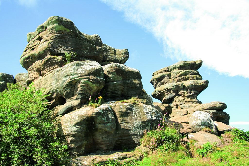
In this feature, Brian Spencer takes a nostalgic visit to one of the strangest geological features in Britain. Currently out of bounds during lockdown, it is somewhere Brian plans to revisit once freedom of movement is available. Brimham Rocks, sometimes called Brimham Crags are a group of strangely eroded millstone grit rocky towers high above the western edge of a183.9 hectare (454 acre) moorland escarpment overlooking Nidderdale, 8 miles (13km) north west of Harrogate. Such is the importance of the site that it is classed as an Area of Outstanding Natural Beauty. Along with the rocks, the surrounding moorland is home to semi- rare wild creatures and acid loving plants, all living in and around birch woodland on a large unspoilt area of both wet and dry heath. The major attraction to the site is its strange water and weather-eroded rocks, which were formed over many millions of years from sediments laid down in a huge river delta. Subsequent earth movements and ice and river erosion left an escarpment high above what became the River Nidd. The escarpment splintered into rocky towers over the millennia which, in turn separated into inter-connected boulders and rock faces. During the mid-seventeen hundreds an interest developed in what was called New-Druidism. Manmade rock circles and other unusual rock features in the landscape were considered to be the work of druids. Brimham Rocks became the venue for many of the philosophical thinkers of the day, who wrote quasi-serious essays following their visits to Nidderdale. In line with the then current ideas, they gave fanciful names to many of the rocks; they came up with names such as the Druid’s Idol, Druid’s Altar and Druid’s Writing Desk which have lasted into modern times. Brimham Rocks are formed from a semi-coarse sandstone laid down in the later part of the Carboniferous period in what became the Pennines (rocks on Kinder Scout were similarly laid down around this time). Due to the sands being deposited in moving streams which changed direction from time to time, it resulted in cross-bedding. This is very evident in most of the Brimham outcrops. Weathering in the Ice Age and windblown sand even now has led to the weaker and harder strata weathering at different rates; this resulted in the towers’ weird and fanciful shapes. We prefer to travel up to Brimham Rocks by way of Skipton and Pateley Bridge a few miles to the north along Nidderdale. Being on an old coaching road, the village is well appointed for cosy pubs and interesting shops – it even boasts having the oldest sweet shop in the country. True or not, being sold toffees from a glass jar takes us oldies back a few decades. Pateley Bridge was even once connected to the railway network. For a long time it was the terminus of a branch line from Harrogate, left over from a railway laid to supply building materials to three reservoirs being built towards the head of Nidderdale. From Pateley Bridge we took the steep road climbing the east side of the dale as far as a cross roads at Low Laithe. From there a left turn joins an even steeper road thoughtfully signposted to Brimham Rocks, our destination. Turning into the car park we got our first glimpse of the wonders to come. Rather like something out of a John Wayne cowboy movie, piled boulders and rock towers beckoned from the surrounding dwarf silver birch and a friendly National Trust attendant pointed out the start of a little path that winds through the trees up to the first of the named rocks. While many of Brimham’s druidical rocks were named by antiquarians in the eighteenth century, others have more fanciful names given to them by caretaker guides based at Rock House in the centre of the moor in order to attract paying visitors. Our first contact with named rocks came quite soon after walking along the narrow path diverging from the central track leading to Rock House. Part of a long sinuous escarpment of broken rocks it is the Surprise View over-looking the length of Nidderdale far below. This was just a taste of things to come and we followed them to a rock tower with a perched dog-like stone called inevitably, the Watchdog. Not all the rocks have ‘official’ names and we soon began to enjoy ourselves by inventing names that fulfilled our imaginations. The one I spotted was a perfect rendering of a cartoonist’s version of the late Prime Minister Margaret Thatcher MP. Named rocks begin with the Watchdog, but the most modern and arguably the best is the Smartie Tube; here we swung round through isolated outcrops, all the time wondering what it would be like to explore the moor in thick mist or a snow storm. Thoughts of a Sherlock Holmes adventure came to mind or some-thing out of a Hammer Horror film would revel in the unusual setting. The path, fortunately in glorious sunshine, led us back towards the central track, stopping first at an area called the Cannon Rocks; why this is so I am not sure, but the next outcrop across the track, is called the Blacksmith’s Anvil and is easy to find because of that. All the paths seem to join at the bottom of a hollow where the Eagle and Castle Rocks hold sway. That was until a bunch of hooligans bounced the rocker out of balance. To their right the Flower Pot and Oyster Shell seem to be the result of a gardener with a vivid imagination. The space beyond opens out to offer somewhere to rest and enjoy a little refreshment. Rock House, now a Grade II Listed Building once a hideaway for sportsmen harassing the moorland grouse and occasional wild deer is now the Visitor Centre from where in better times guided tours of the rocks are on offer. Immediately to the left of the Visitor Centre, the Dancing Bear stands proud on his rocky plinth.
Walk Derbyshire – Elton & Gratton Dale

This walk explores one of the lesser known parts of the White Peak. Properties in Elton where the walk starts, would be easily recognised by any returning inhabitant, even after the passage of long forgotten centuries. At one time there were two villages, Gratton as well as Elton, but following an outbreak of the Black Death plague, Gratton was abandoned, eventually reappearing as a scattering of small cattle and sheep farms clustered around a dairy specialising in the production of a unique crumbly white Derbyshire cheese. Many of the farms in and around Elton were rented by part-timers who divided their above ground activities with small-scale lead mining. Their activities can still be traced from the numerous spoil heaps and capped-off access shafts dotted around nearby fields. As the price of wool declined in recent years, dairy farming became the major activity, with Oddo House Farm on the west side of Elton running the largest herd. It is many years since local milk was sent down the hilly lane to Gratton, there to be made into cheese; the abandoned dairy now serves as a well restored domestic dwelling and holiday let. Starting near Elton’s quirky pub, the Duke of York, the walk follows a field path which skirts an abandoned Saltway between Ashbourne and Bakewell. It was diverted eastwards when Elton Common was enclosed. Ancient footpaths lead to the mother church in Youlgreave, but the oldest track by far is the Portway about half way between Elton and Winster. Prehistoric in origin, it can still be traced locally where it crosses the valley of Ivy Brook below Birchover; aiming for the crags of Robin Hood’s Stride, it passes a hermit’s cave marked by a simple crucifix carved into the rocky shelter, the path continuing below on its long way between the River Trent and Mam Tor. After crossing the enclosed fields of Elton Common to reach Gratton Dale, this pretty dale is part of the cluster of dales and limestone moor forming a Site of Special Scientific Interest (SSSI). The dale is a natural habitat for semi-alpine plants and wild orchids. Muddy in places the path follows a route beneath a ruined lime kiln towards Gratton, another link with one of the local industries. At the dale end, the path joins a narrow lane running past the Old Cheese Factory. Here a right turn beyond the lime kiln links with a short climb which returns to Elton, passing the village church with a copy of its unusually designed font. DIRECTIONS : 1.From the church, follow Moor Lane opposite, for about 200 yards beyond the Duke of York pub. If the church is open, call in to see the font. This is a copy of the original one left outside when a new church tower was being built following damage caused by lead miners working too close to the foundations. The original font is now in Youlgreave church, and Elton’s copy is a faithful rendition of the Saxon original. 2.A little way beyond a de-restricted speed sign near the turning for Back Lane, leave Moor Lane by turning right into a farm track. It is not uncommon for field access tracks to be named locally, but this one is a rarity because it has a metal street nameplate just as if it were a busy town street even though there are no houses along its length, just being a way to the fields on Elton Common. The name of the track in this case is Hungerhill Lane (sometimes also known as Ongrill) 3.Follow the track for a few yards as far as a stile next to a finger post. Turn left here and follow a field path across a series of fields for about a mile. The ivy covered ruin to the left of the path near its start is all that is left of Dawson House where the local lead agent lived in the 18th Century; lead agents bought ore from local miners, but were not always too popular as they could not be guaranteed to give the best prices. Using gates and stiles to keep to the line of the path, continue until you reach an overgrown track. Cross this by way of stiles and continue forwards across yet more fields, keeping to a straight course until the main road is reached. 4.The path has reached the Winster/Newhaven road at its junction with the A5012 Cromford/Newhaven road. Go through a stone stile, turn right and follow the grassy verge for about 150 yards. 5. When Mouldridge Grange Farm comes into view to your right and below, look for a narrow stone stile in the wall again on your right. Go through it and follow the boundary wall, straight at first, then curving left behind the farm. The word Grange in the title for Mouldridge Grange Farm indicates that it was once a monastic farm or grange. In this case it was owned by Augustinian monks of Dunstable until the sixteenth century dissolution of the monasteries by Henry VIII. 6.Bear left and then right and go downhill into Gratton Dale. Turn right to follow the dale as far as its junction with the Elton to Youlgreave road. Gratton Dale is part of a Site of Special Scientific Interest (SSSI), well known for its limestone loving flowering plants and field orchids. Where the dale-bottom path joins a farm track coming from the right by a gate, look to your left. The wide horizontal hole in the hillside is not a mine, but the lower part of an abandoned, but well preserved lime kiln. Locally quarried limestone would be burnt here to create lime for spreading on fields in the area. The hamlet of Gratton is a pleasant cluster of farms and restored cottages. It is well worth exploring. To your left the second building along is the old cheese factory. The factory is now a popular holiday let, but it was once the source of an excellent
The Village of Elton – A Journey Through Time

Even though prehistoric travellers following the Portway from the Trent to Mam Tor would have passed through the area, modern Elton can be overlooked. Being off all the through roads crossing the limestone uplands of the Peak, it is easy to ignore, but as a Michelin Guide might say, ‘it is well worth the diversion’. The village lies about half a mile in any direction from the B5056 Cromford to Bakewell or the Winster to Newhaven roads and a turn off either leads down to Elton village. Home for many years for the lead miners who sought the scant riches from beneath local fields, Elton has existed in one form or another for at least 5,000 years, but its first official record was in the Domesday Book when 18 families made their living from farming the upland pastures. The village took its name from the first recorded farmer Aelfwine, better known as Ella who developed his ‘tun’ or small farm here around the 8th or 9th century. Over years, Ella’s tun became Elton. The first settlers who followed Ella built farmsteads along Well Street where there was a small spring. This joined what became Main Street connecting Winster road, where a church was set up on the north side and a pub, the Duke of York to provide refreshment diagonally opposite. Of course all this took time, but gradually a village of pleasant stone cottages spread along Main Street and Back Lane to its south. Most of these properties became farm labourers’ homes, many of whom combined farming with part-time mining. The best place to start any exploration of Elton is from its church. The present church dedicated to All Saints dates from the early 1800s, replacing a much older medieval chapel whose spire collapsed in a storm. It is thought that it had been weakened by miners illegally digging too close to its foundations when following a potentially rich vein of lead. A curious story links Elton church to Youlgreave’s, or at least its font. Dating from Saxon times, Elton’s font with its attached stoup to hold Holy Oil was dumped outside the church by workmen when the place was being renovated. Once the new church was ready, no one thought about taking the font back inside and it slowly began to disappear beneath the weeds. In the next part of the tale Youlgreave’s curate happened to spot the font lying there un-appreciated. Youlgreave must have been in need of a new font for without due ceremony it was moved from Elton and to this day holds pride of place near Youlgreave’s door. Elton folk then realised their loss and asked for their font to be returned, only to be told ‘sorry, it’s ours now’, or words to that effect. All that Elton could now do was to have a copy made by local masons. Lead miners held the belief that beer cured lead poisoning, if they were around today they might have to give the Duke of York inn a call. The pub, standing across the road from the church once had some rather odd opening times, but nowadays it is open most evenings and lunchtime on Sunday. The pub, a Grade 2 listed building, has kept its name and character for over 200 years and is a perfect example of a rural English hostelry. At one time there were two more pubs in Elton to slake miners’ thirsts. These were Nelson’s Arms and the Red Lion, but only the Duke of York has stood the test of time. Before setting off to explore the main part of Elton, it is recommended that visitors start at West End part of Main Street and walk downhill as far as Gratton, Elton’s next door neighbour. Before Elton’s fields were enclosed, allowing stock to wander at will, a small field on the right was called the pinfold. Here strays were held until their owners paid an appropriate fine. Elton’s major farm, Oddo, fills most of the land to the south of West End. Today, following the gradual amalgamation of most of the farms in the district, there are now only five, mostly concentrating on milk production. Dairy farming has always been an important part of the local economy and at one time there was a cheese factory producing light, crumbly white cheese. No longer is Derbyshire cheese made at Gratton, but the building has been tastefully converted into a private house and holiday let. Anyone remembering the ITV series The Mallan Streak, will have seen the cheese factory prior to its conversion. The then abandoned building masqueraded as a wayside inn and for several years its sign tantalised unwary passers-by in need of a drink. Back uphill to the church, the main part of the village is roughly triangular in shape, spreading east on both sides of Main Street. Two short lanes, Stone Foot and Ivy Lane connect with Back Lane to the south overlooking nearby grazing. More houses surround the church, running north along Well Street and Joule’s Croft. A few modern houses are built on both sides of Main Street at its eastern end overlooking the village sports and recreation ground. Most of the houses in and around the centre of Elton date from the seventeenth and eighteenth centuries and are probably built on older foundations. The following notes cover just a fraction of the oldest and most interesting buildings squashed in cheek by jowl in a delightful mix of styles, but most have been built with locally found stone, mainly gritstone from Birchover Quarry across the valley. From the top of West End, the steep road up from Gratton passes a mix of older type properties along with a scattering of bungalows owned by Dales Housing. Moving up into West End, the substantial double-fronted Lawson Cottage was a privately run dame’s school dating from the 1870s. Turning left into Well Street, the Old Rectory was built in 1838 and was the birthplace of Rhoda Garrett
Lost Houses of Derbyshire – Stretton-in-Shirland

It is entirely through the thorough researches undertaken by Gladwyn Turbutt that we have a good, comprehensive history of this lost house and its occupants. Derbyshire historian Stephen Glover wrote in around 1832 that the house overlooked ‘one of the finest valleys in the county’ and if you were to go to our excellent Museum at Derby you will see Joseph Wright’s painting The Rainbow, which is understood to have been painted by the river Amber just below the house which, in its heyday, was set in a small park of unusual beauty. And indeed, Joseph Wright had strong connections with the house (as he had with lost Yoxall Lodge in Staffordshire through his long friendship with Derby’s slavery abolitionist Thomas Gisborne). When I wrote about Derwent Hall, we encountered a house that was lost to the building of a reservoir, and Errwood Hall was also a secondary casualty in Derbyshire of a house lost to the desire of local authorities to flood valleys of incomparable beauty to quench the thirst of the citizens of adjoining towns. Regrettably, Ford House and its predecessor, Ford Old Hall (or House), were also casualties of this ecologically unfriendly aspect of having to deal with a burgeoning population. Some time in the Tudor era, a family called Curtis held a modest estate at Ford, but they enjoyed the status of yeoman farmer rather than of gentlemen. In the seventh century John Curtis married a daughter of their near neighbours, the Revels of Ogston Hall, subsequently became a Quaker and in 1680, with the encouragement of a Revell kinsman, migrated to America where his progeny still flourish. The Curtis family must have built the old hall, a single range of which survived into the twentieth century, and which was the subject of a postcard issued by a local firm at Alfreton. What one sees is a lowish two storey range of coal measures sandstone with two light mullioned windows set with cast iron casements and topped with a stone slate roof. To the right was a later range, and the whole functioned as a farmhouse until it met its nemesis. Swathwick, in Wingerworth, who initially added the range to the right of the Old Hall around 1700, allegedly as a malthouse, although the formality of its architecture rather suggests increased accommodation for Holland who had married three years before. Yet he was a maltster, and a successful one, but one feels that the epicentre of his trade would more likely have been in Alfreton, three miles away. In 1713 George was succeeded by his son Thomas, whose accounts partially survive, entries from which suggest that he spent £100 building stables in 1721 and a few years later spent £336 for ‘building the house at fford’ which is usually taken to be the Ford House that survived to be photographed. Yet there are reasons to doubt this. The three photographs I have been able to dig our (three of them locally printed postcards) show the house as a three storey stone building, of coal measures sandstone, ashlared to the main (east) front and of random rubble brought to course at the sides. It had a hipped roof, a cornice supporting a dwarf parapet and three bays of paired sashes to the main façade, a most unusual arrangement for the date. The pediment at the centre of the ground floor was clearly not intended as the main entrance, as it spanned two bays like the rest, of which only one serves as a door, almost certainly to give access to the garden. The entrance was clearly in the courtyard behind and to the left. To the left too there is a single bay of superimposed paired mullioned but sashed windows, roughly the same height as the main range and beyond that a courtyard connecting to a very pretty stable block consisting of a pediment over a triple arcade. The main house is most emphatically not in the style of George I, nor is the stable block for that matter. Looking at the two storey range to the left (the south wing) I suspect this is all that was suffered to remain after a later building campaign, of the original house, possibly a rebuild of an earlier building (Mr. Turbutt suspects that earlier stable block of the Old Hall which stood behind to the north). This remnant, latterly the kitchen wing, included an inscribed pane of glass to ‘Thomas Holland de Ford in Com. Derb. Gent. Decimo Quarto die Aprilis Anno Dni 1729’ This must surely be a commemoration of the completion of the building, for which the £336 payment was part. What was there latterly looks remarkably like a late eighteenth century house, although the paired windows are still a rare feature. Furthermore, the stables look a little earlier if anything; the arcade under a plain pediment closely resembles the summerhouse built by Joseph Pickford at Ashbourne Mansion around 1763 and in the early nineteenth century was embellished with stone balls to the gateway and wall in true Palladian tradition, these details known only from a contemporary painting. Finally, although the 1720s accounts break off, incomplete, £336 for a substantial house (unless a payment on account) is not a lot of money. Thomas Holland died in 1776 and, I suspect, at a much later date than his youthful building programme, he had the stables enlarged and embellished, probably in the 1760s, using an architect not unfamiliar with Palladian motifs, perhaps Edmund Stanley of Chesterfield, who oversaw the building of the new hall at Ogston nearby to the designs of Joseph Pickford of Derby. Thomas was succeeded by his son John, an altogether more sensitive man than his father. He married in 1777, his wife Mary being sister-in-law to his equally cultivated neighbour William Turbutt. The couple entertained at Ford an important network of enlightenment friends including painters like Wright and his friend William Tate, the abolitionist and collaborator of William Wilberforce, Revd. Thomas Gisborne and
Alison Uttley’s Cromford – then & now
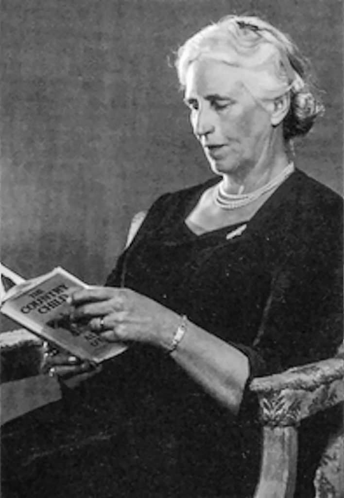
In the 1930s, countryside author Alison Uttley wrote a series of short essays based on her childhood experiences in and around Cromford. These were later produced in book-form by Scarthin Books. Currently out of print, it is possible to find a much-cherished second hand copy; armed with one of them, Brian Spencer looks for what became of the shops and businesses that once cared for the everyday needs of people living in Cromford over a century ago. Alison Uttley was born as Alice Taylor, on December 17th, 1884, at Castletop Farm, between Cromford and Lea Mills. A highly intelligent girl, she began her academic career by winning a scholarship at Lady Manners Grammar School in Bakewell. From there she went on to study Physics at Manchester University, taking an honours degree, one of the first women to enter the field of science. Following a teacher training course at Cambridge, she taught Physics and English in Fulham for three years before coming back to the North of England after marrying James Uttley. Moving to Buckinghamshire where she spent the rest of her life, her writing career began in 1931 when, as a widow she had to support herself and her infant son. Her first book was ‘The Country Child’, an autobiographical novel based on her early life as the daughter of a farming family. This was followed by much-loved children’s stories such as ‘Little Grey Rabbit’ and ‘A Traveller in Time’ and many other novels and plays, some of which have found their way on to the small screen. Although she never returned to Derbyshire, she began to write about her early experiences in and around Cromford. Here she would go by pony and trap with either her father and mother, or just the one, in order to buy their everyday needs, or have repairs made to the horse’s harness, or maybe watch while the farrier fixed the pony with a new shoe. Cromford in her time and well into the twentieth century, was a completely self-supporting village. It really did have the traditional Butcher, Baker and Candlestick maker, along with draper’s shops where Alison and her mother could buy a new bonnet. Her father could be measured and fitted with a new suit, or buy medicines for a sick cow. There was even a cobbler and a wheel-wright, in fact everything a busy village attached to Sir Richard Arkwright’s thriving cotton mill would need. Armed with a copy of the village map (see below), we soon discovered that while none of the businesses Alison or her parents relied on still exist, most of the buildings are still there sheltering other commercial interests, or even converted into private houses. Though the businesses have changed, the village is still laid out as it was in her day, and so our trip round Cromford was easy to follow. We started our walk round Alison Uttley’s Cromford with a late breakfast at the quirky wooden café that stands on the corner of Mill Road, above Arkwright’s Mill, where many of Cromford’s inhabitants made their living. Very little has changed with the café building apart from its use. In Alison Uttley’s time it was a barber’s shop, a place where the local men could socialise. Taking our lives into our hands we crossed the A6 and began to follow the left side of Cromford Hill Road. Beyond the small war memorial garden, the first building on our left is the Community Centre built on the site of the local flour Mill. A ladies’ hairdressing salon shares one corner, using what was once the village blacksmith’s place of work. Beyond a narrow gap a chip shop and cafe (one of two chippies supplying the village), fills what was once a post office, then comes a private house where there was a pork butcher’s shop, then later a bank. Beyond it Arkwright’s Store struggles against changing grocery needs, but next to it is probably the only unchanged shop in the village; this is the village newsagents where young Alison bought her penny dolls. Moving on up Cromford Hill, the next shop of interest comes next to a narrow drive accessing a group of cottages. This was where Alison and her mother bought ribbons to rejuvenate their hats. It later became a dress shop, but now looks after the requirements of the areas plumbers. Stone built houses line the road in a mixed selection of styles, many of them include a stocking frame knitter’s workshop in their upper stories. These cottages continue up to and beyond North Street, the street and school built by Richard Arkwright Junior to provide accommodation for his workers and stocking frame knitters. The street is built to give each side a fair share of sunshine, the north in the morning and south in the afternoon. Two commercial buildings stood at the entrance to North Street; on the left is the elegant bow front of what was once a butcher, but is now a private house. The Bell Inn is opposite, having partly extended into the grocer’s shop, once its next door neighbour. If anyone who lived lower down the hill wanted a loaf of bread they would have to climb to what is now the next door neighbour to the Bell, for that is where the village baker worked. Returning to the bottom of Cromford Hill, Water Lane carries quarry traffic along the Via Gellia. At the lane’s junction with the hill road, a general merchant uses part of the old carpenter and wheelwright’s workshop. An Aladdin’s Cave it fulfils D.I.Y needs and everything from sledges to wrought-iron display stands. It would have been well known to Alison’s father. Moving along Water Lane, past the closed Co-op shop that came and went after Alison Uttley’s time, the pond on your right gave power to Arkwright’s early mills. It also collected water draining from local lead mines: this was collected via a complicated system of channels behind the houses and shops at
Celebrity Interview – Rachel Swann
Update – February 2026 Derbyshire’s first female Chief Constable has now officially announced her retirement. We have published full coverage of the announcement, including key dates, career highlights and reaction from across the county. 👉 Read our full retirement coverage here:Rachel Swann announces retirement as Derbyshire Chief Constable (2026) ————- It’s a situation only a select number of people have experienced: waiting for the Prime Minister to ring. The circumstances in which Rachel Swann was preparing to address Boris Johnson were certainly unusual: she was responsible for the largest peace-time evacuation of civilians in the UK in the hope of averting an unparallelled disaster. At the time Mrs Swann was Derbyshire Police’s deputy chief constable and in charge of the operation to move 1,600 people from Whaley Bridge after the dam at Toddbrook reservoir began to collapse. As part of her duties she had to brief the Cabinet, chaired by a government minister, at daily COBRA meetings – a committee that takes action in national emergencies. “It was an odd moment waiting for the PM to ring you on your mobile,” says Mrs Swann. “The PM called me on the Friday morning – the day after it all happened, offering his support and asking me what we needed. “The COBRA meetings were very helpful in terms of making sure our response was joined up and in helping ensure we had military support. I have to say the military were brilliant throughout, as you’d expect.” Mrs Swann is now the Chief Constable and the first woman to hold the position in Derbyshire. In August last year, the media around the world reported how she managed more than 2,000 people including fire and rescue workers, the armed forces, the county council’s emergency planners, ambulance staff and flood rescue teams as a catastrophe was avoided. But she points out that the collapse of the reservoir wasn’t a question in her interview. “What I would say is that the incident helped me to demonstrate my leadership in a crisis. It very quickly meant I built up good partnership relationships in a short period of time. “As a force we saw just what we could do in a crisis and there were many individual acts of bravery and commitment to keep people safe. “This was a large operation and the lessons learned have been extensive. This has been extremely helpful in how we’re dealing with the Covid-19 challenge.” While she was widely praised for her handling of the rescue operation, others took a different view: she was targeted on social media with misogynistic and homophobic slurs, mainly because of her hair. She has a quiff which is spiked up and dyed blonde. At the time she said what really hurt was the people who said she had no standards and was letting policing down. But a number of people defended her, including Councillor Barry Lewis, the leader of the county council, who said: “Be under no doubt: she saved a valley. That’s what’s important.” It led to her taking a break from Twitter. But Mrs Swann points out that social media has many positive aspects. “It enables you to reach many people that you wouldn’t do normally, on a much more regular basis. It allows our teams to tell people what we’re doing about local issues which is really important. “We also found in Whaley Bridge it was invaluable: we used the police account as the one source of accurate information and could effectively deal with rumour and speculation before they caused unnecessary fear. “But it does have a downside as people ignore normal, polite rules of conversation and use it to criticise in a very unrestrained way. “It was a surprise to me just how many negative comments I had and how much momentum it gained. But I’m more prepared for that now and make sure I minimise my exposure to it.” She also realises how digital technology is “critical” in making the force more adaptable to change, working more efficiently and tackling criminals. “We know that fraud and other offences are moving online and there’s a concentrated focus in forces across the country to disrupt, detect and pursue those responsible – and to help protect people in their online lives.” Rachel Swann is 49 and was born in Cornwall. She did not consider the police as a career after a police officer went to her secondary school and put her off because he said she was too small. After graduating at Loughborough University she worked in a gym. A friend said she was applying to join the police and Mrs Swann learned that the height limit was no longer in existence. She thought she might give policing a go “as it appeared to be a good, interesting career with lots of opportunities”. She was still living in Leicestershire, so she joined that county’s force on its graduate entry course as a PC in August 1994. She stayed there for 20 years and looks back on it as an enjoyable time. “I’ve benefited from quite a diverse career and worked in both the rural and urban parts of the county. I’ve also worked with some really fantastic people, which makes all the difference. “I really enjoyed being head of specialist operations – I was responsible for roads policing, dogs, firearms, public order, etc. That was the role I really wanted and I was fortunate enough to get it in 2010.” Her proudest moments were working with Team GB’s Olympic training camp at Loughborough University and being involved in the Queen’s visit to Leicester as part of her Jubilee celebrations, both in 2012. Three years later she went to Northamptonshire as assistant chief constable, becoming deputy in 2017. She arrived in Derbyshire in February 2019 as deputy chief and in August 2020, after 26 years’ service, she landed the top job. Mrs Swann has a number of priorities: “It’s really important to me that we deliver a good service consistently, one which our communities trust.” Other
Lost Houses of Derbyshire – Appleby Hall
It is astonishing how many country houses and estates were lost to Derbyshire in the boundary adjustments of 1888 and 1936; in this column we have visited several, including Measham and Willesley Hall, Norton House, Hazlebarrow with others. As they had been part of Derbyshire for about 900 years prior to their unwilling transfer, I for one continue to regard them as Derbyshire country houses, lost or not. One of that plethora of islands of Derbyshire marooned within the borders of Leicestershire and lost in 1888 (in exchange for which we gained only Nether and Over Seal in this area) was the delightful village of Appleby. Appleby Magna lay partly within our county whilst the subsidiary township of Appleby Parva was mainly in Derbyshire. Anciently the manor belonged to the Applebys, whilst an estate that included the Derbyshire portions of Appleby Parva came to the Vernons of Haddon. Whether the latter had a manor house there, like the splendid moated remnant of the seat of the Applebys, still standing in Appleby Magna, seems unlikely. In 1598 a man called Charles Moore purchased much of the old Vernon estate, to which was added two decades later further land along with part of Norton-juxta-Twycross by his homonymous son. Although the old histories, like William Woolley describe the family as ‘of mean account’ this was clearly not the case, mainly because both Charleses had the money to buy the land in the first place, the elder having lived previously at Stretton-in-Shirland, and because the family, who began indeed as farming stock in Lancashire, were then London merchants. The second Charles’s younger son was Sir John Moore, Lord Mayor of London 1681-1682 and Tory MP for the City of London, a man who enormously increased the family’s wealth. Sir John’s father or elder brother (a third Charles), seems to have built a manor house, but lived at Snarestone, letting it in the 1670s to Henry, the newly married son and heir of Henry Kendall of Smisby Hall, and on which he was taxed for 13 hearths, indicating that the house was of moderate size. Unfortunately, we have no evidence of what it looked like, although if the precedent of Sir John Moore’s Grammar School nearby, designed by Sir Christopher Wren (albeit somewhat diluted by the dubious talents of Sir William Wilson), is anything to go by, it might have been very handsome. John Nichols’ History of Leicestershire informs us that it was pulled down in 1770 and became the site of its successor. In 1775, Charles Moore of Appleby FRS (again, a non-resident) died without issue, having five years earlier demolished the family seat. His uncle Thomas had living in Appleby manor house, but died in 1762 leaving an elder son, Revd. Thomas Moore, who built in a new house in 1770 called The White House, illustrated by Nichols, but which stood to the NE of Appleby Magna, safely in Leicestershire (hence Nichols’ inclusion of it.) Thomas too died without issue in 1795 upon which the estate came to his half-brother George Moore, later High Sheriff of Leicestershire. He set about building a new house on the site of the previous manor, at first called Appleby House. The contract still exists in family hands for its building, signed by the architect/builder Thomas Gardner of Uttoxeter, a former colleague of Joseph Pickford of Derby, who oversaw on his behalf the erection of Etruria Hall, works and workers’ village for Josiah Wedgwood. At the time, Gardner was building the hall nearby at Thorpe Constantine for the Inge family, who still have these plans and elevations. It was thanks to the late Ambrose Moore that I was able to see the contract for Appleby, which was estimated at £1,861, and to his much-missed son Peter that I was able to glean further information. The document makes it clear that the house was more or less as photographed in Edwardian times; of ashlar coal measures sandstone, two and a half storeys high with a south front of five bays, the central one being embellished by a pediment supported on attached Ionic columns flanked by matching pilasters, with a heavy-looking tetrastyle portico at ground floor level in baseless Doric. The parapet was supported upon a grooved entablature and there were antae (plain broad pilasters) at the angles. The east front consisted of two shallow bows with tripartite windows on the ground floor and first floor in the centre only. The north front was of but four plain bays and was otherwise unembellished although throughout all the windows were set in moulded surrounds. This handsome and modest sized house stood in parkland perhaps landscaped by William Emes, part of an estate that then ran to 3,778 acres. The house was a more elaborate version of Barton Blount, completed by Gardner for Derby banker Samuel Crompton a few years before; many of his larger houses are much more austere as, indeed, Thorpe Constantine and Loxley in Staffordshire. Inside, decoration was restrained with good chimneypieces but there was a magnificent top-lit cantilevered Hopton Wood stone well staircase rising throughout the house in its centre, with an iron rail almost identical to that at Barton Blount. A contemporary lodge was built to the west on New Road – essentially the original road south from Magna but re-aligned to allow the parkland to be laid out. Gardner also designed the elegant red-brick rectory nearby which, happily, still survives. The lodge was raised by a storey post war, and more recently extended to the north and also survives. George More was a great agricultural improver and under him the estate flourished, so much so that his son was able to extend the house in a two storey approximately matching style to increase accommodation and enlarge the two and a half storey service wing, the employment of additional staff and the formalizing of life in the country house becoming a feature of the period. The year was 1836 and the architect Henry Goddard of Leicester.
Changing Landscapes
The change in season brings with it many delights and yet there are some areas that on occasion turn from foreboding landscapes into fascinating scenes of vibrant colour and light. On a summers evening in August the Cat and Fiddle road that connects Buxton to Macclesfield was a delight to traverse necessitating a stop just opposite the now closed Cat and Fiddle public house to take in the most wonderful views. It all looks so inviting as the sun starts to dip over the hills, but this ever changing landscape makes this area on a winters day, or summer for that matter, fraught with danger. I have travelled this road in a pea- souper of fog as the headlights desperately fought to pick out the cats eyes on the road , and in a blizzard with the wipers straining hard against the fast falling snow. The black ice, hidden from view, suddenly causing the tyres to loose their grip and manically trying to avoid going off the edge of the road. Throwing everything into the mix it’s a pretty deceptive landscape that has seen its fair share of fatalities, but it is one of outstanding beauty when the soft colours of heather outline the moors with their fingers. The road now is subject to average speed cameras. This decision is mainly due to those who attempt to overtake in the wrong place and cause enormous problems. It’s a great road if used properly but sadly many don’t seem to have grasped that and so take risks and pay the price. Reports show that of the 264 casualties on the road since 2001, approximately 70% of those killed or seriously injured were motorcyclists. I suppose for all who enjoy driving it’s a drivers road and brings with it an elements of excitement but needs treating with respect. Whilst the Cat and Fiddle area can be a very inhospitable place you only have to travel a mile or two in each direction to be in areas of outstanding natural beauty with country walks. Dropping from the Cat towards Macclesfield near the village of Wildboarclough (Wilbercluff if you’re a local! ), the area of Maccclesfield Forest is rich in beautiful country walks. The Cat and Fiddle Inn is the second-highest inn or public house in England at 1,689 feet or 515m, Having been closed as a pub for a few years it is now occupied by The Forest Distillery where its cellars, that are 1600 above sea level provide perfect conditions for whisky to mature. Tha Cat and Fiddle is currently open for coffee and take outs, and if you fancy a tour they can be booked on line. There are four reservoirs in the vicinity, Ridgegate and Trentabank reservoirs provide Macclesfield with drinking water. Trentabank is home to the largest heronry in the Peak District. The forest timber is regularly felled and replanted so the woodland scenery is always changing . Pay and display parking is available at the Visitor Centre near Trentabank Reservoir and at another small car park at Standing Stone. There are also other minor car parking areas in lay-bys in the forest. Travel back from the Cat towards Buxton to visit Derbyshire Bridge, originally the county boundary between Derbyshire and Cheshire. It nestles in The Goyt Valley which was once the home of a thriving coal mining industry. Remnants of mine shafts can still be seen dotted around. There is a car park and picnic site which offer some stunning scenery and walks across the moors. Sadly there’s no access to Goyt valley by car as there is a one way system in operation so you will need to attack the rest of the valley by taking the A5004 Buxton to Whaley Bridge Road. From Derbyshire Bridge a lovely walk takes you alongside the River Goyt down to Packhorse Bridge and back taking approximately one and a half hours. Wildboarclough, nestled in a valley in Macclesfield Forest, Cheshire is such a fascinating little village steeped in history. It was an area of industry with two mills linked in with the carpet industry which used Clough Brook as its power source to run the machinery. The bridge over the river has a plaque on it to commemorate the loss of life after a flash flood in 1989. It is also reputedly the place where the last wild boar in England was killed although that fact is a little disputed! The nearby summit of Shutlingsloe gives outstanding views of the Cheshire Plains and on a clear day you can see the Mersey Estuary and the Welsh Clwydian Hills 40 miles away. We sawJodrel Bank clearly in the distance as we drove along. Whatever your preference, sitting on the top of the Cat and Fiddle is a great place to take a coffee and cake and just soak in the atmosphere come rain or shine. You may even get to see the planes taking off and landing at Manchester airport if it’s clear. All in all a great day out and only a hop skip and a jump from home. 00
Walk Derbyshire – Howden & Derwent Reservoir Walk
Distance: 10.3 miles of easy road walking, mostly through woodland followed by a gravel track above Howden and Derwent Reservoirs. Recommended Map: Ordnance Survey Outdoor Leisure Series Sheet1; The Peak District, Dark Peak Area Public Transport: Hulleys and TM Travel 273, 274 & 275 Two Hour Service from Bakewell and Sheffield via Castleton and Bamford. Car Parking: Fairholmes Visitor Centre. N.B. Please note that the valley road is open to walkers, cyclists and horse riders, but it is closed to cars and motor cycles on Sundays and Bank Holidays from Easter to end October. Bus service from Bakewell, Sheffield via Castleton and Bamford (railway station). Refreshments: Fairholmes Visitor Centre. Although man-made, the flooded section of the Derwent Valley can vie with most of the English Lake District. Three reservoirs built over fifty years during the early to mid-twentieth century, have mellowed into an attractive amenity for all users. Trees planted at the same time as the reservoirs were built, have now matured and generally being of mixed varieties, make a perfect foil to a remote scene composed of water backed by wild moorland. Starting with Howden at the upper section of the valley, each dam and ancillary features such as culverts and filter beds, were built individually, one after the other gradually moving downstream. In order to accommodate the over a thousand-strong workforce, a village of corrugated iron huts was erected, catering for every need from groceries, to a doctor’s surgery and a barber’s shop. The village was known officially as Birchinlee, but soon found its way into the vernacular as ‘Tin Town’. The walk passes the site of Tin Town. Nothing remains of the actual buildings, but overgrown terraced ledges still mark the street pattern. A roadside plaque tells the story of a village that disappeared once its purpose was fulfilled. However, one of the corrugated iron buildings managed to survive, not above the reservoirs, but in Hope village where it serves as a ladies’ hairdresser’s salon. Another feature part of which can be traced on the ground, is the track bed of a light railway built to carry massive blocks of stone each weighing several tons, and destined to become part of the reservoir dam walls. It ran from a quarry near Bamford. During World War 2, because of its resemblance to the Mohne and Eder reservoirs in Germany’s industrial Ruhr, crews from the R.A.F’s 617 Squadron used Howden dam to hone their skills in dropping Barnes Wallace’s ‘bouncing bomb’. To do this the Lancaster bombers, based in Lincolnshire had to fly under cover of darkness in order to reach Howden. Using the twin towers of the dam as aiming points, the cylindrical bombs were skimmed along the water up to the dam, and then rolled down to it before exploding near its foot. In Germany the exploding bombs created pressure waves that destroyed the dam’s structure, releasing billions of tons of water to flood a vast part of the Ruhr industrial belt. There is a small museum commemorating the exploits of 617 Squadron, the ‘Dam Buster Squadron’, in the western tower of Derwent Dam. Ladybower, the largest and most southerly and last of the reservoir threesome was completed around 1945. The whole complex was officially opened by HRH King George VI who planted an oak tree now officially known as the King’s Tree. Growing steadily for seventy-five years near the end of the valley road, it has developed into a sturdy young memento of the king’s visit. This walk passes the tree on the final leg of the section above the west bank of both reservoirs. The track no longer has to cross the Derwent by hopping over a series of stepping stones, well known as Slippery Stones. The crossing is now done dry-shod, by way of the narrow pack-horse bridge that once stood near Ashopton village. When Ladybower reservoir was built, the village together with its hall and church had to be demolished (along with the dozen or so farms flooded by it and Derwent and Howden). To re-house families displaced by flooding the valley, a new village, Yorkshire Bridge, was built below Ladybower dam. At one time during droughts, the spire of Ashopton church appeared once more, but as it was considered a danger to anyone trying to get close, it was demolished. All that is left of the village are the twin gate stones standing at what was once the entrance drive to the hall, and the memorial plaque to Tip a faithful sheep dog who kept vigil over his master’s body when they were lost in a blizzard. The walk starts and finishes at the Peak District National Park Fairholmes Visitor Centre car park, close to the head of Derwent Reservoir. There are public toilets and a refreshments cabin available throughout the year. Please note that the valley road is closed to visiting cars and motor cycles on Sundays and Bank Holidays from Easter to the end of October. A bus service (Hulleys and TM Travel 273,274 & 275) runs from Bakewell and Sheffield, both via Castleton and Bamford every two hours. DIRECTIONS From Fairholmes car park, turn right on to the valley road, and start to follow it past the dam wall of Derwent Reservoir. Follow the road. Although traffic is light even during times when it is open to cars, please take care to be on the lookout for oncoming cars. As you walk beneath the mature trees on either side of the road, look for a series of terraces, the road layout of ‘Tin Town’, once the home of over a thousand navies and their families when they built the three reservoirs. There is a roadside plaque which tells the story of this long abandoned village. Passing the dam of Howden Reservoir, continue along the road and bear left, then right with it around the western arm of one of Howden’s feeder streams (Westend River). Continue along the road for a couple more miles until it reaches the King’s
The Peak District Mining Museum
The easing of lockdown made it possible for museums at least to partially re-open, and the Peak District Mining Museum in Matlock Bath’s Grand Pavilion was quick to take advantage of it. With its easy access, visitors can explore the story of lead mining in the Peak District. Everything is open except the popular children’s climbing shafts, which cannot be reopened in case the dreaded Corvid-19 virus lurks in dark recesses. Otherwise everything, including the popular Temple Mine is open to carefully spaced visitors. Lead mining is the Peak’s oldest industry, it began in pre-Roman times, in fact it was the acquisition of lead for their plumbing and roofing needs that first attracted Roman conquerors to Derbyshire. Apart from a handful of sites, lead mining was very much a two-men and a dog sort of industry. A glance at the Ordnance Survey map of the White Peak shows literally scores of sites marked as Mine (disused), or simply shown as mounds dotted across open fields. The place name Bole Hill is another frequently mentioned link with a long-gone industry. Usually on or near a hilltop, it indicates that a bole, or crude smelter was once nearby. Boles were small affairs, simply a three-sided stone fireplace facing the prevailing wind. It was here that a charcoal fire melted lead ore which was then run off into moulds, creating the traditional ‘pigs’, or ingots of useful lead. It took an age to produce a fother (ton) of lead and another thousand years or so to make any improvements. This came about in the mid eighteenth century with the invention of reverberatory or Cupola smelters. Rather than mix fuel with ore, the new system relied on intense heat bounced off furnace walls, producing greater amounts of refined lead. One of them can still be explored; it surrounds the square chimney standing on high ground at Spitewinter between the Matlock/Chesterfield and Darley/Dale Chesterfield roads. Once inside the museum, the first exhibit is a lifelike miner and his truck of ore. Behind him, but currently out of bounds is the entrance to one of the climbing shafts. These realistic effects run between the ground and first floor of the museum, making a perfect adventure playground post Coronavirus. A word of warning though to any well-padded adult, don’t try climbing while wearing bulky clothes like I once did. Reaching daylight at the top, I managed to get well and truly stuck. All I could see was a large pair of shoes at floor level topped by a bulky male. Looking down at me, he grinned and said; ‘Another daft b—– like me, give us your hand’. A quick yank and I was out, and I’ve never tried it again, but the grandchildren loved to disappear into the gloomy recesses. Set pieces like the miner figures made from plastic tubes are shown amongst the tools of their trade, such as the ‘whisket’, a simple basket which held their day’s delving below ground. Don’t try to pick up the massive lump of lead ore as it weighs over half a ton. There cannot have been many similar lumps brought out of Peakland mines, most of the daily production was at best, made up of pieces the size of a man’s fist, or smaller. It had to be dressed (broken up), usually by miners’ wives and washed in the river to remove as many impurities as possible. Water below ground and removing it was always a problem. The most efficient way was by a drain, or ‘sough’ (pronounced ‘suff’), if the mine was above the level of a convenient river, but this was a rare event. The alternative was by a mechanical pump, or the cruder rag pump like the one on display. Another popular children’s exhibit, it is an endless chain of rag-filled links which, when turned by a handle, mops up water and brings it to the surface. A clanking and grinding sound usually indicates that some child (or adult for that matter), is enjoying the task, but imagine spending all day turning the heavy handle. A more efficient system stands opposite the rag pump. Basically a vertical pipe a little over a foot in diameter festooned with all manner of valves and mysterious pipes, it came out of Wills’ Founder Mine at Winster where it had done yeoman service for the best part of a century. The work of dismantling it underground and then rebuilding it in the museum, was done by volunteer members of the Peak District Historic Mining Society. Photographs, each telling a story are dotted around the museum and range from a poignant shot of Charles Henry Millington (1878-1968), the Peak District’s last working lead miner, to historical shots of now long abandoned mines. On display are fascinating models of mechanical pumps and surface views of mines such as Magpie Mine near Sheldon, or horse-drawn stone crushing circles, the remains of which can still be found half hidden in bracken dotted around the local countryside. Attractive displays of stone collections show just how colourful many of the ores buried deep beneath the ground can be. Temple Mine is an abandoned drift mine running directly into the limestone hillside a little way beyond the entrance to Gulliver’s Kingdom. It was last used to mine fluor spa (calcium fluoride a source of the fluoride in tooth paste). We were lucky to find a family of four there, taking advantage of their museum entrance fees. They had just spent part of the previous hour on a guided tour exploring the mine’s inner nooks and crannies and were finishing off their visit with a spell of panning for gold. There really is gold in them thar hills, but it is of the fool’s variety – iron pyrites, (iron sulphide FeS2). Currently the Peak District Mining Museum is open Wednesday, Saturday and Sunday from 11:00 a.m, until further notice. Please wear face masks and keep a couple of metres away from other visitors. 00