Walk Derbyshire – Combs Reservoir

Combs Moss is an outlier of the higher moors of the Daark Peak. It sits between Buxton and Chapel-en-le-Frith, mainly overlooking the latter. Looking upwards from Chapel, a long escarpment dominates the skyline, marked by two protruding side ridges radiating from its eastern edge. The further of the two, between Combs and Short Edges, is the site of a pre-historic fortress. Using the steep drop on its northern side a double defensive series of ditches at its back, made it an almost impregnable outpost. Using the steep slope of the escarpment, enemy attackers coming from the north would be seen long before they reached the difficult slope rising beneath the fort. With rough moorland slowing attackers from the south and east, whoever held the fortress would have plenty of time to prepare themselves from anyone wanting to use surprise in their favour. Combs is an anglicised version of the Welsh word ‘cwm’, meaning a mountain hollow. This hollow became an ideal place to build a reservoir supplying water for the Peak Forest Canal, the northern arm of a canal network linking Trent and Derwent Valley waterways to the North West by way of a railway across the dry limestone countryside of the White Peak. Peak Forest Canal runs west from Whaley Bridge joining the north western network at Marple where it links the industrial Midlands with Lancashire. I have a special interest in this walk around the upper reaches of the Combs Valley. During my first camp with a scout troop, we pitched our tents in a farmer’s field just outside Combs village. One of our walks followed a rough path up on to the escarpment, the route following one of the side streams. The sight of what seemed endless miles of rough moorland stretching south when we crested the escarpment lip has never left me, and I am sure it formed the start of my love of wild places and high mountains. The walk starts and ends at the car park below Combs Reservoir, a popular sailing spot. Next it follows the reservoir’s western bank to its end before turning along a country lane into Combs village and its friendly Beehive Inn. A winding field track climbs up to a point close to Chapel-en-le-Frith station, before dropping down to Chapel Golf Course and the side of the main road back to the car park. USEFUL INFORMATION 3 miles (4.8km) of frequently rough waterside paths and across fields. Maximum ascent 164ft (50m). Many stiles in field boundaries. Muddy after rain. RECOMMENDED MAP Ordnance Survey 1:25,000 scale, Sheet OL24; White Peak Area. PUBLIC TRANSPORT Bus services and trains from Buxton. CAR PARKING Car Park below Combs Reservoir dam. REFRESHMENTS Beehive Inn at the centre of Combs village and the Gate Inn on the village access road junction with the B5470. THE WALK From the car park below Combs Reservoir, and keeping the reservoir on your left, follow the path climbing beside the dam and turn left to follow the western bank of Combs Reservoir. Follow the course of Meveril Brook as it runs parallel to the reservoir. Ignore the first footbridge on your right after a little under half a mile. At the four-way path junction at the narrow far end of the reservoir, turn sharp right, go over the footbridge beside the path junction and cross to follow a field path. Go under the railway bridge and then follow the path up to a minor country lane. Turn left along this lane which leads directly into Combs village. Bear left beyond the Beehive Inn, then follow a side lane for about 100yards until it joins another lane, signposted to Dove Holes and again bearing left. Turn left and climb this lane for a little over a quarter of a mile as far as Rye Flatt Farm. Turn left opposite the farm, on to a field path winding its way around the curving hillside. Take the left hand path after a little over 200 yards. Keeping beneath the access drive to The Lodge, which will be on your right, follow the path as it descends towards the railway. Join the access drive away from The Lodge (a one-time sporting retreat). Go under the railway bridge and follow the Lodge drive downhill as far as Down Lea Farm. N.B. Many of the footpaths on the next half mile have a reputation for being some of the muddiest in the district, especially after a prolonged period of rain. About 100 yards beyond the farm look out for a footpath on your left. Join this and walk towards Marsh Hall Farm, about a quarter of a mile distant. Bear right away from the farm for about 120 yards as far as a footpath junction where you should take the path bearing left. Walk downstream above a deep-cut stream and then in a couple of hundred yards and at the next footpath junction, bear right to cross the golf course. Take care to follow the waymarks across the links. Reaching the road, the B5470 turn left and using the pavement on the far side, follow past the road junction for Combs village. Continue along the main road towards the dam end of the reservoir, cross over and then turn left for the car park. For anyone relying on public transport, there is a bus stop close to the junction with the village road. There is another pub, the Hanging Gate on the opposite side of the road, conveniently close to the end of the walk. 00
Walk Derbyshire – Thorpe Cloud

Two prominent hills guard the southern entrance to Dovedale; bulky Bunster rises to the west at the end of a broad limestone ridge, while Thorpe Cloud’s graceful summit looks to the east. The steeper of the two, the Cloud has footpaths on three sides and as such has become a popular venue for walkers looking for a short exciting scramble. Alternatively it makes the centre piece of a little known walk linking the Dove and Manifold Rivers close by their junction. This walk begins at the Dove Dale car park, before moving along a short road through the tight gap between the Dove’s guardian hills. At the road end (it is really there to guide anglers to the start of their beat), the famous Stepping Stones take walkers over to the opposite bank. An alternate crossing can be made if the river is in flood, by using the wooden footbridge closer to the car park. If we were to continue to explore upstream along the path over the high rock we come to the place where an eloping parson came to grief a couple of centuries ago. From the stepping stones, this walk turns right to pass round Thorpe Cloud’s lower slopes, by climbing broad Lin Dale. A grassy track reaches the Ilam road next to a public toilet. Thorpe village dots the far side beyond the main road and the walk then follows a series of quiet back roads, past the village church, before dropping down to Coldwall Bridge over the lower reaches of the Dove. Nine out of ten visitors ignoring Thorpe’s charm fail to realise that its foundations date from at least Norman times, but all that is left from that time is the unaltered tower of its church. A wide track drops down to the river, here rather incongruously crossed by a wide stone-arched bridge. This is Coldwall Bridge, nowadays used only by walkers and the occasional farmer on his tractor. Hard to believe, but the bridge once carried an important road, the turnpike between Staffordshire’s Cheadle and Chesterfield, a road that was abandoned almost as soon as it was opened. From the far Staffordshire end of the bridge, a riverside path leads down to the river bank which is followed upstream past the confluence of the Dove and Manifold rivers all the way into Ilam village. Ilam’s Hansel and Gretel cottages originally provided homes for estate workers on the local estate. Ilam Hall home of their lord and master is now a youth hostel based in the property owned by the National Trust. These original owners were the Watts-Russells shipping magnates, the first of whom, Jesse Watts-Russell commissioned George Gilbert Scott, the famous Victorian architect to design a mansion competing with the Earl of Shrewsbury’s Alton Towers. His grand ideas were only enjoyed by two generations of the family, but they had left their mark on this corner of the Peak. The mock –Eleanor cross at the road junction was erected by Jesse Watts-Russell in memory of his first wife, who if folk memory is correct, was not over popular amongst the local tenantry. A much more revered settler in the quiet hollow where Ilam sits was St Bertram, a Saxon saint who preached the gospel to his tiny flock. He spent his days meditating beside the well on the side of Bunster Hill that bears his name, or in a tiny cave below Ilam Hall where the resurgent River Manifold again sees the light of day. His memorial, once a place of pilgrimage, is in a side chapel of Ilam church. The walk on reaching the village, climbs up to the road bridge, then bears right on to the Thorpe/Tissington road. This is followed a little way beyond Ilam’s last houses as far as a kissing gate on the left. Through this your path climbs sharply to the right before crossing a series of fields behind the Izaak Walton Hotel, then back into Dove Dale and not only the car park, but a welcome coffee at the friendly kiosk. USEFUL INFORMATION 4.5 miles (7.25km) of moderate walking along clear paths and through riverside meadows. Muddy places on the Ilam side of Coldwell Bridge. RECOMMENDED MAP Ordnance Survey 1:50,000 Landranger Series; Sheet 119 Buxton, Matlock & Dove Dale PUBLIC TRANSPORT Buses: Warrington’s 44 service runs between Ashbourne and Ilam. CAR PARKING Dove Dale car park – reached from the Thorpe to Tissington road (signposted). REFRESHMENTS Kiosk on Dove Dale car park. Izaak Walton Hotel (when open). DIRECTIONS From Dove Dale car park, follow the surfaced track upstream beside the river until it reaches the famous Stepping Stones. (If the river is in flood, use the wooden footbridge a few yards above the car park). Reaching the east bank, turn left to leave the river and then bear sharp right and begin to walk steadily uphill, at first beside a limestone wall. Cross the wide col and begin to go steadily downhill towards Thorpe village. Go past the public toilets, then cross the main road in order to reach the side lane opposite. Keep to the right of the church and then follow a side lane going steeply downhill towards Coldwell Bridge and the river. A milepost at the side of the lane indicates that the bridge was once part of the long-abandoned turnpike between Cheadle (Staffs) and Chesterfield. Cross the wide bridge and turn right at the far end. The path is partly screened by shrubby undergrowth and the going around this point can be muddy. So keep as high as is reasonable in these conditions and once the muddy section is crossed, steadily drop down towards the river bank. Bear left and follow the river upstream. The path reaches the river more or less where the Manifold flows into the Dove. At this point there is a fine view of the twin bastions guarding Dove Dale and, at their foot the Izaak Walton Hotel pays homage to its illustrious namesake who along
A Brief Look Around Markeaton, Mackworth & Kedleston

Some of Derbyshire’s finest and most sequestered countryside may be found west of Derby itself, although it is countryside well removed from ‘classic’ Derbyshire: the spectacular sequences of White and Dark Peak. West of Derby is gently undulating arable country, scattered with miniscule villages, some shrunk, some beginning to expand again, interspersed with country houses, delightful churches and the sites of other such settlements, long deserted, like Meynell Langley and Barton Blount. MARKEATON As such, the area is impossible to encapsulate in a single visit; the winding lanes, their erratic courses determined by the ancient boundaries of pre-existing land holdings, would always preclude so adventurous an enterprise. Instead, we proposed a taster, one that would take the voyager never very far from the City of Derby, yet still experience something of that ambience. We decided to start from the parkland which formerly surrounded Markeaton Hall, thoughtlessly demolished in 1964. Mercifully, a former owner, Mrs. Mundy, donated much of the park (along with the house) and the Council bought more (see Country Images for March and April 2012). We drove past the re-positioned hall gates, now restored and facing the Markeaton Roundabout on the Ashbourne Road. They look splendid, but they are wasted in such a position. In return for parking up, we were relieved of a certain amount of money for the privilege, so be warned! The parkland is today just over 200 acres and was landscaped around 1760 by William Emes, who was a prominent locally based follower of Lancelot ‘Capability’ Brown who specialised in lakes, although that at Markeaton was widened to allow boating by the Council in 1932. For twenty glorious years, the park was embellished by a miniature railway, mainly steam operated, closed by the Council in 2014, who refused to maintain to a decent standard the buildings leased by the railway’s proprietors, thus allowing repeated entry to vandals. It is much missed. We began at the pet cemetery at the SW part of the park, then moved via the surviving buildings to admire the surviving plinth of the early Tudor hall, incorporated by Joseph Pickford when he rebuilt the stables as a magnificent two-courtyard hunting stables, buildings with a rich heritage, subsequently diminished when demolished. What is left is the orangery (the roof much altered) and a single courtyard behind, the latter peopled by craft retail outlets which, once life gets back to normal, are always worth a visit. From thence proceed westward out of the park, past the west lodge, in which one 18th century gate pier is half-embedded and indeed, can be seen from within the upstairs room! Here one is in what remains of the village, moved here when the park was landscaped but embellished by two fine earlier farm houses, a tea shop and garden centre. It still retains the pleasant semi-somnolent appearance of the estate village it once was, and is one of the few remaining true pieces of rus in urbe remaining within the city. Markeaton and Mackworth were essentially lumped together in Domesday Book, and as you look west from Markeaton village, the spire of Mackworth church (founded by the Touchet family of Markeaton somewhat later than Domesday) can be seen. Indeed, the Roman Road from Little Chester to Chesterton (Staffs.) ran from here directly across the fields to the church which was built across its alignment. Its course is marked by the lane for a hundred yards, which then diverges left from the alignment, whilst it continues across a field, the agger (raised plinth) on which it lay and a hedgerow marking its course. We chose to retrieve the car, and drive along the Ashbourne Road (with the Markeaton parkland and the old Ashbourne road alignment on our right) to the traffic lights at Radbourne Lane, where we turned right down the lane to the church. Unfortunately, last December this beautiful edifice, listed grade one because of the rich collection of local carved alabaster within, was utterly gutted through the efforts of an arsonist, and now makes a sorry sight and is partly barricaded off. Yet hope is at hand, as it was well insured and Historic England have insisted on its re-instatement. The Roman road runs in front of the church’s south door. I know this because in 1981 I directed two Archaeological Society excavations to find and record it and the east part duly showed up clearly. Oddly, to the west of the berm of the churchyard, there was no sign of it at all! The earth for a metre down had been cleaned, probably by a flood, of all vestiges! To the SE of the chancel is the Mundy vault with its locally made but strangely pretty iron brattishing, and to the immediate west of the path to the south door is a substantial stone monument, the inscription upon which is to Sarah, infant daughter of William Emes, who lived at Bowbridge House a little west of the village on the main road. Yet a little further west of the poor, forlorn church, the alignment of the Roman Road converges with the village street here called Lower Road. A walk along it as far as Jarvey’s Lane, where a brick double pile early Georgian farmhouse makes a gratifying marker, is a complete delight. The village, never large, but which largely supplanted Markeaton from the mid-18th century, is still essentially an estate village, for the Mundy family’s heirs, the Clark-Maxwells continued to farm the estate despite the last Mrs. Mundy giving the house to the Borough. The handsome Victorian vicarage of 1877-78 (since the death of the much-admired Revd. Henry Dane, now privatised), the ornately decorated school, and several of the houses were designed by Robert Evans of Nottingham (1832-1911) who opened a Derby office with William Jolley on the back of extensive work for the Markeaton Estate. MACKWORTH One building clearly not by Evans, of course, is the shell of the stone gatehouse built four hundred years earlier, when part of
The Lost Houses of Derbyshire – Stretton House

Stretton, along with Measham and Appleby Parva (for the lost houses at which see Country Images December 2019 and October 2020), lay within a large ‘island’ of Derbyshire, separated since Saxon times from the bulk of the county, itself created in the mid-10th century. This ‘island’ also included Oakthorpe, Donisthorpe, Chilcote and Willesley (see Country Images for March 2018 for the lost hall there) and in another, even further south, lay Ravenstone, all since 1888 safely transferred to Leicestershire, except Chilcote which went to Staffordshire Not only that, but Stretton is about the most sequestered place you could possibly find in the local area, despite lying north of Appleby and west of Measham flanked by the A42 and the A444, the river Mease forming the third side of a sort of topographical triangle. With a population barely in double figures there is a fine church, St. Michael, long redundant and with an uncared-for look and a strange brooding atmosphere – or so it appeared to me and Mick Stanley when we visited, in the process of writing volume two of The Derbyshire Country House in 1981. The site of the hall was covered by what appears to be a tangled growth of impenetrable bocage. Even when Nichols was writing his history of Leicestershire over two centuries ago (in which these Derbyshire islands were included) the village was essentially a seriously shrunk one, having but the hall, a mill, the church and a few cottages. The Domesday tenant under Robert de Ferrers was almost certainly the ancestor of the de Stretton family, which managed to hang on to the estate, despite some intervening hiatuses until at the beginning of the fifteenth century it was split between three cousins, being later united by the Findernes of Swarkestone and then sold to the Blounts of Barton Blount, Lords Mountjoy. In around 1540 they sold the estate to John Browne of Horton Kirby, Kent, a London merchant and Henry VIII’s mint master. His father and grandfather had both been Lords Mayor of London, so there was no shortage of cash with which to invest in land. John’s son built a new hall at Stretton towards the end of that century. It continued with the Brownes until the death of William Browne in 1744, whereupon it descended to his grandson John Cave, also of Ravenstone nearby and of Eydon, Northamptonshire. In that same year he added the surname and arms of Browne to his own. In 1757 he married, which in due course necessitated him enlarging the hall, according to Nicholas, ‘by a large stone edifice on the north side’ probably in the 1760s. It is this house of which that author provides an engraving, revealing the late Tudor house as having had two storeys with attics in four gables of which the central pair broke forward. There were string courses above the mullion and transom cross windows, tall slim chimney stacks and a low wing to the north east. In 1670 there were 12 hearths taxable, indicating a reasonably substantial house but it was at that time divided as two distinct households between John Browne and the widower of his half-sister, Christian, Henry Adams. John Cave’s addition, as the engraving makes clear, did the north side of the house no favours aesthetically, being three full storeys high and essentially a canted bay added centrally, uniting the two central projecting gables, like a Palladian penetrating pediment. Here, there was a double string course and sash windows, pedimented on the ground floor with the windows either side of the addition turned into, on the left, a segmentally headed niche and on the right by a matching doorcase and all crowned by a pyramidal roof, the whole arrangement looking thoroughly awkward, although the fault may well lie with Nichols’ artist who made the sketch for the engraving. The architect may have been Joseph Pickford’s contemporary William Henderson of Loughborough (c. 1739-1797) whom we encountered when talking of Measham Hall, trying to make the best of a bad job. Yet the arrangement, bearing in mind that all this new accommodation faced north, cannot have been wholly satisfactory. What precisely he did to the garden front, however, seems to emerge later, when we look at the next stage in the alterations. John’s son, William, in 1810 inherited the baronetcy of the Caves, succeeding a distant cousin as 9th baronet, subsequently adding Cave to his already double-barrelled name by Royal Licence in 1839 thus ending up as Sir William Cave-Brown-Cave. Sir William’s son, Sir John decided in 1845 to do something about the house, Bagshaw remarking that in that year it was ‘undergoing considerable repair’, which is something of an understatement, for the appearance of the surviving mansion demonstrates that he essentially pulled down much of the previous house – probably piecemeal, so that the family could continue living there – and largely rebuilt it. The south (garden) front had clearly been similar to that on the north, but the 1757 rebuilding seems to have led to the deletion of the central two gables, and the insertion of a two storey, five bay recessed centre with Georgian sashed windows, a feature also applied to the windows of the gables. In 1845, a further bay was added at each end of the façade and the gables embellished with ornamental bargeboards, the architect being clearly influenced by the contemporary enthusiasm for the cottage orné style, as championed by John Claudius Loudon, creator of the Derby Arboretum. Judging from the low pyramidal roof just visible over the roof in the Keene photograph of the south front the awkward canted bay of 1757 was allowed to remain. Unfortunately, no photograph of that side of the house has ever emerged to tell us how it was primped up. Despite this, the house was let in the 1850s, first to Charles Colville of nearby Lullington Hall (whilst his house was being rebuilt) then to Capt. Lewis Conran, a military friend of the family
Exploring Winster
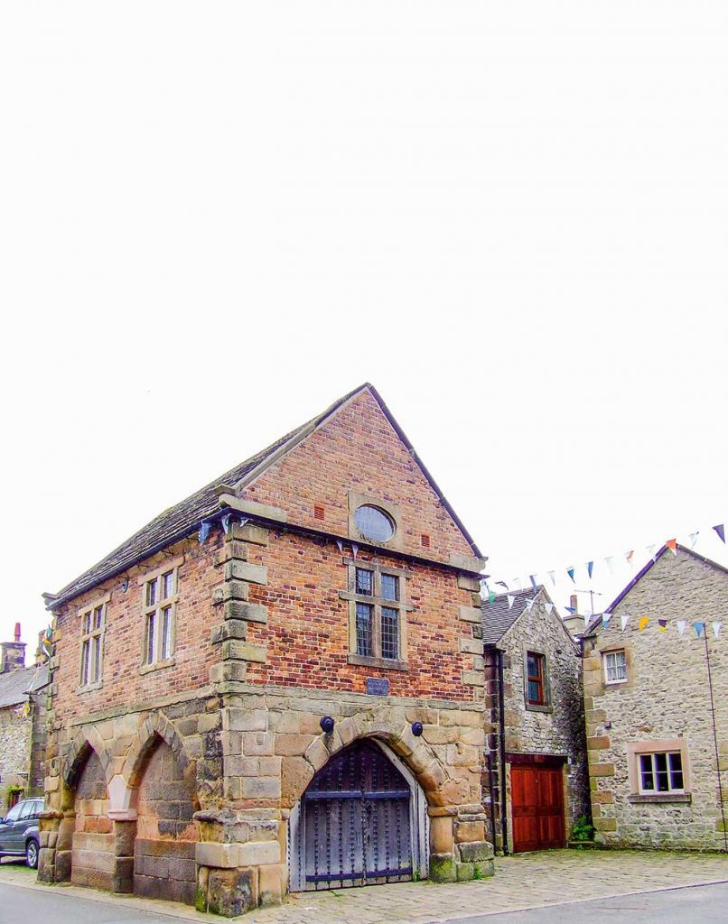
It is hard to imagine that the picturesque village of Winster with its 700 or so inhabitants was once a small town providing a home base for around 2000 souls, many of whom relied on lead mining for their livelihood. This brought considerable prosperity to the place, something that is evident in the quality of several of the grand houses lining Winster’s Main Street. However, it is the backwaters and narrow lanes climbing the nearby hillsides that reveal the real flavour of this picturesque village. Occupying an upland location 700 to 900 feet above sea level in the south-east of the Peak District National Park, Winster can trace its roots as far back as the Domesday Book (1086). In this compilation it is recorded by its Saxon name of ‘Winsterne’. The name possibly meant ‘Wyn’s thorn tree’ after a prominent local landmark; the title ‘Wyn’s Tor’ given to a group of limestone rocks above the village is quite recent, dating from around 1840 when they were still being recorded as ‘Wildmister Tor’. The village sits on the north facing slopes of a broad valley draining the junction between limestone in the south and shales and gritstone further north. It is the geology of the region which gives Winster and its neighbour Birchover on the opposite side of the valley their individually distinctive character. Where the houses and boundary walls in Birchover are made from gritstone, Winster’s are mainly limestone. It is possible that Roman lead miners were the first settlers to make their home in this idyllic spot, delving for the metal, first close to the surface then gradually going deeper. The boom in lead mining came in the late seventeenth century during which what had once been a tiny hamlet grew in size to a prosperous town, one of the largest in Derbyshire, there were even mines a matter of yards away from miners’ homes. Due to flooding when the mines deepened, those around the village were gradually abandoned, with only nearby Millclose employing local men until it too eventually closed in 1938. Several artefacts discovered by mine explorers are on display in the Mining Museum at Matlock Bath, with pride of place being given to the huge pump dating from 1819. This was discovered in Will’s Founder Mine near the Elton road. As well as being an important centre for lead mining, since pre-historic times Winster sat astride major trading routes – the Portway from the Trent valley to Mam Tor passes close to the village as well as salt routes from Cheshire and the eighteenth-century turnpike from Nottingham to Newhaven (on the A515 Ashbourne to Buxton road), actually passed through Winster. The only way to explore Winster is on foot and we began by parking in the small car park at the head of the common outside the village. The road away from the common is known as East Bank and it runs steeply downhill to join Main Street at the Market House, but we were to take a more complex route through the maze of narrow passages called gennels or jitties in the Peak District. In the middle of cottages surrounding a field over to our left were three heavy concrete slabs covering the top of a 265 feet deep shaft leading to Wesson Mine, last worked for lead in the 1850s. Like most mine shafts in the Peak great care must be taken by anyone wanting to view them – there is another shaft, not so well capped, in nearby bushes; this and Orchard Mine. Further down the village streets were two more mines, handy for miners living close by. The first house on the right as we walked downhill along East Bank is Pinfold Cottage, behind which are the remains of a small pen or ‘Pinfold’. This is where stray animals were kept until claimed by their owners. Almost opposite the cottage we came on the left, to the first of Winster’s village criss-crossing gennels, this one leads past one-time miners’ cottages and their attractive gardens (Winster holds its ‘Secret Gardens’ on open days in June), to a rarity for Winster, the aptly name ‘Flat’ where a polite sign lets it be known that it was only wide enough to park Minis. Bearing right we came to a gate through which we could see the spoil heap of Orchard Mine; the size of the mine is indicated by the grassed over spoil heap spilling down towards Woolley’s Yard. We then re-joined East Bank near the Bowling Green Inn where a regular cattle market used to be held. The pub along with the Miners’ Standard was once just one of twenty inns and ale houses that slaked the thirsts of miners in the mistaken view that it was a cure for lead poisoning. The bowling green which gave the pub its name is now buried beneath its car park, but an ancient wood can be seen behind the bar. A cruck beam gives some hint of the pub’s age and many of the houses opposite were once small shops serving the needs of farmers on market days. Standing on the corner of East Bank and Main Street is the Market House, the first Derbyshire building owned by the National Trust. It dates from 1711 when Winster was granted the right to hold Saturday markets and was built around that time, although the lower part may be older. The uniqueness of its construction is that the upper story and gables are not stone but brick-built, probably to save weight, with the bricks being made locally in a temporary kiln. Exhibitions of a local interest are frequently held in the upper room. Cobbles at the back of the market make an attractive setting for the Italianate frontage of Lansdowne House and Newholme, then a little further on along the road to Wensley is The Manor, where a mounting block outside the gate indicates that it was surely a place of some importance.
Tried & Tested – This Works

Give you body extra nourishment this spring with these products from This Works Deep Sleep Body Cocoon 100ml £25.00 This multi-tasking wellness solution will encourage calmer nights and nourished skin. WHY?… Multi-tasking wellness solution for calmer nights and nourished skin. WHEN?… Use each night to bring calm and relaxation, moisturising the skin whilst sending you into peaceful slumber. HOW?… Our unique Superblend of Shea Butter, Crambe, Camelia and Sativa oils will help to nourish and support the skin’s barrier, while our original Deep Sleep fragrance of Lavender, Camomile and Vetivert will help send you into a restful slumber. In The Zone Shower Gel 300ml £24.00 Re-focus the mind with a balancing blend of Eucalyptus and Frankincense. WHY?… Get back in the zone and feel ready for the day, wherever it takes you. WHEN?… Calm and centre a busy body and mind each time you step into the shower. HOW?… A Superblend of Eucalyptus, Patchouli and Frankincense. Sulphate free and 99% natural. Skin Deep Dry Leg Oil 120ml £42.00 An award-winning oil blend which transforms dry, dull legs into shiny, soft skin. WHY?… Legs often get neglected – try this multi-award winning leg oil to keep your limbs in tip top condition all year round. WHENY?… Massage in daily – post-bath or shower – to tackle dry, rough, undernourished skin on legs and body, re-hydrating and enhancing dull skin. HOW?… This luxurious, 100% natural Superblend of thirteen high-grade essential oils and six cold-pressed plant oils includes Rose Oil, protective Tuberose, hydrating Sandalwood and calming Evening Primrose, which together help maintain the lipid skin barrier and reduce visible signs of ageing, including dry, scaly, dull skin. For more information and to buy online visit www.thisworks.com TRIED & TESTED TRIED & TESTED TRIED & TESTED Shower Gel I love the pump action packaging. This smells like your in a spa. Lathers up really well and smells so nice. VP Body Cocoon I’ve never used a product like this before. It smells so nice and calming and leaves skin feeling really lovely. CB Skin Deep Dry Leg Oil Yes this really does work. A perfect cream for the start of spring, with 19 botanical oils, I found this to be light, quickly absorbed and after only a few days I started to notice the difference. JP 00
Tried & Tested with Neal’s Yard Remedies

Love your Locks with Neals Yard Remedies. This month we tried out 3 beautiful shampoos from the Neals Yard Range. We love the fact they’re organic! Give them a go. Revitalising Orange Flower Shampoo 200ml £11.50 Our revitalising shampoo restores a natural shine to normal hair. The nutrient-rich blend of moringa, camellia, passion flower and neroli nourishes and cleanses your hair and scalp. All our shampoos have a natural low lathering foam to avoid stripping away the hair’s natural oils, which can leave it feeling brittle and dry as well as irritating the scalp. •For normal hair. •Floral blend of essential oils. •Restores natural shine. •Low lathering foam. Invigorating Seaweed Shampoo 200ml £11.50 This refreshing shampoo contains mineral-rich seaweed and stimulating herbal extracts to suit all hair types. The gentle blend of botanical extracts and fresh scented rosemary cleanses your hair and scalp •For all hair types •With mineral-rich extracts •Low lathering foam. Nuturing Rose Shampoo 200ml £11.50 Our nurturing shampoo enhances the vibrancy and shine of dry, damaged or coloured hair, leaving it looking and feeling smoother. The blend of vitamin-rich rosehip, sea buckthorn, and passion flower oils gently cleanses your hair and scalp, and helps to minimise split ends. •For dry, damaged or coloured hair. •Improves vibrancy and shine. •Low lathering foam PRODUCT TEST :: PRODUCT TEST :: PRODUCT TEST :: Orange Flower Shampoo Smells divine. Lathers up really well and left my hair feeling really clean and shiny. VP Nurturing Rose Shampoo Unfortunately, lockdown has not done my hair any favours with being in a centrally heated environment for most of the day. The gentle oils and low lather formula of Neals Yard have helped to remedy it and my hair feels all the better for it. JP Seaweed Shampoo Seaweed has been used for 1,000’s of years with well known health benefits. So I found this shampoo gentle, it didn’t irritate my scalp, but cared for my hair in a natural way without harsh chemicals, and left it feeling in good condition. CB 00
Walk Derbyshire – Three Shires in a Flash

Children will love this walk, for where else can they visit three counties within a matter of seconds? The highlight of the walk is the bridge known as Three Shire Heads, where Staffordshire, Cheshire and Derbyshire all meet at a point in the middle of an ancient pack horse bridge over the River Dane. To reach it means following moorland tracks radiating from Flash, the highest village in England, although some claim it to be the highest in Britain, backing it with a road sign erected by no less an adjudicator than the Peak District National Park Authority. Winter starts early in Flash and lingers long after spring has arrived in more sheltered places. The wind is keen but refreshing and the views far ranging. Counterfeiters once carried out their nefarious trade in remote farmhouses around Flash and its name has since become linked to any suspicious or ‘flashy’ object. During the first half of the 19th century the population of the parish was around 700; but it had reduced to around half of that by the end of the 1800s, and even less today. Most of those living there at that time were either agricultural labourers, roughly the same number of coal miners, stone masons, a dressmaker, blacksmiths and cordwainers (shoemaker who used fresh leather), an errand boy, wheelwright, gamekeeper, grocer, pedlar and even a tailor as well as a brewer and a number of house servants. Following them were 275 young people and 50 scholars. Not everyone could find regular employment and at one time almost a quarter of the population were drawing relief from the parish. Most of the village’s working inhabitants commute to Leek and Buxton, or further these days. Nowadays Flash still has its own little brewery and a small general store attached to the café at Flash Bar on the Buxton road. Links with old-time Flash are apparent in a number of small, though still viable and now part-time farms, dotted about the moors. During the 1800s and earlier, the farms were frequently run as a second means of employment by colliers who delved in the shallow though now overgrown pits that lie in wait of careless walkers in this day and age. Long before the advent of radio and televised broadcasting, news of the outside world was conveyed word of mouth by passing travellers such as pack horse drovers making their way along the winding moorland tracks surrounding Flash. The Ordnance Survey map shows ‘Pannier’s’ Pool beside Three Shires Bridge, a welcome resting place for both drivers and ponies. All was not always completely calm at this spot if stories of illegal bare knuckle prize fighting are correct. St Paul’s, the parish church also covers the nearby hamlet of Quarnford. The present building, a Grade II listed dates from 1901, but was probably built on medieval foundations. As with many other remote moorland villages, Wesleyan Methodism was well established in the 18th century and the chapel was built as early as 1784. As a short addendum, this might help to explain how the inhabitants of the Peak District uplands around Flash cope with winter: I was speaking to the head master of Earl Sterndale Junior School one day and I asked him how they coped with heavy snow. ‘It is easy’, he explained,’ we have an early warning system in place.’ Apparently this early warning is given by their school-run taxi driver who lives at Flash. When things start to look bad he collects the Flash children, but before doing so he rings Earl Sterndale School, telling them to get the children ready for collection. Simple! DIRECTIONS 1. Walk out of Flash village, downhill along the minor road to the right of the New Inn for about ½ mile (800m). 2. At a bend at the bottom of the hill, turn right along a concrete driveway. Do not enter the farmyard. 3. Turn left just before the farm and cross the adjacent wooden footbridge in order to follow the direction of a signpost to Three Shire Heads. Climb slightly and follow the path across a couple of fields as far as a farm building in order to reach a lane, 180yds (160m). 4. Turn left and follow the lane which is macadamed at first, but later becomes a sandy track leading down into the Dane Valley, one mile (1.6km). Almost level, it leads directly to Three Shires Bridge. Pause for a few moments, then turn round to admire the view towards the dramatic outlines of Ramshaw Rocks, slightly to your left. The uppermost boulders of the Roaches can also be seen beyond the heather-clad moors over to your right. 5. Go through the gate to the right of Three Shires Bridge and following the river Dane, climb the stony track for about 200yds (180m). Three Shire Heads and the bridge. The bridge which marks the junction of Cheshire, Staffordshire and Derbyshire once carried trains of packhorses and travellers on their journeys between Cheshire, the Potteries and South Yorkshire. Pannier’s Pool beneath the bridge probably got its name from being where horses were rested and watered. Bare knuckle prize fights once took place on the bridge. 6. Turn right over a single-arched bridge. Follow the walled track for about half a mile (0.8km) up to the side road and follow this for about 180yds (160m). 7. Turn right to cross over a stone clapper bridge, then follow the direction indicated by a white waymark arrow on a black disc. It points uphill to the heather moor. The path is indistinct in places, but follows a wire fence on top of an old bilberry covered wall. Change sides as indicated by stiles. 1/2 mile (800m). Look back at the view. Shutlingsloe, Cheshire’s Matterhorn, peeps coyly over the moorland skyline. Tiny farmsteads dot the valley sides. The land is poor and many farms are no longer able to support full-time agriculture. Most are now run part-time, or even as second homes. 8. Go to the
Celebrity Interview – Sir Tony Robinson

Actor, comedian, writer, television presenter and political activist: that’s how many people know Sir Tony Robinson, famous for playing Baldrick in the BBC TV series Blackadder and hosting the archaeological investigation programme Time Team for 20 years. Millions more now know him for a completely different reason: travelling more than 100 miles from his west London flat to adopt a rescue dog from the RSPCA’s animal rehoming centre in Abbey Street, Derby. Pictures of his first encounter with a Westie called Holly Berry went viral on social media as people were captivated by the dog in the same way that Tony and his wife Lady Louise were. The affable, softly spoken, erudite Tony interrupted his busy schedule to chat about how “fantastically lucky” he has been in his career, the chances of Blackadder returning, his reaction to being appointed a knight and the new projects he is working on. But first he explained how Derby came to the rescue when he and Louise decided they wanted another dog after their previous pet had died four years ago. “She went online, we looked at a variety of dogs but for one reason or another things didn’t work out. And then she saw at RSPCA Derby this little mutt that looked like a leather coat that someone had dragged through the mud and left in the corner of the kitchen at a party. Her face was exquisite.” It was just before lockdown and RSPCA officials were not able to go to Tony’s home to check whether it was the right environment for Holly Berry. Tony and Louise filled in lots of forms, had long conversations with the RSPCA about her various health needs, and sent them a video of their home. They were accepted as suitable owners for Holly Berry and travelled to Derby for a “meet and greet”. Branch manager Penny Lockwood welcomed them with Holly Berry in her arms. “The little dog gazed up at me and it was love at first sight,” said Tony. “She’d had a terrible life – she’d clearly been starved. You could see her ribs and she had very little fur. She’d got a serious skin disease, eye and ear problems, and was in a right old state. “My wife instantly knew we’d found the right dog and burst into tears. It was just fantastic. “Six months later she’s a furry ball of love, curiosity, playfulness and energy. She’s always going to be a bit near-sighted – you can’t throw a stick for her more than about 10 yards because she’s no idea where it’s gone! But apart from that she’s really well, absolutely devoted to us and we are to her.” Now Tony and Louise have accepted an invitation to become patrons of Derby RSPCA. They share the charity’s message of “adopt, don’t shop”. “Abbey Street are clearly such a good rescue centre and they’ve given us so much joy with Holly Berry that we’re excited to be able to support their work and help give other potential adopters an experience as wonderful as the one we’ve been through. “We’ve always both been very passionate about adopting not shopping. There are so many animals out there and indeed next year there’s going to be even more. “I saw figures that the Dogs Trust have crunched together which show that every time there’s any kind of economic crisis in the country, within a couple of months there’s a profound increase in the number of strays on the streets.” Anthony Robinson was born on 15 August 1946 in Homerton, east London. He studied for A-levels at school but did not complete them and enrolled at the Central School of Speech and Drama. He spent several years in repertory, worked for two years as a theatre director in Birmingham and then acted with the Royal Shakespeare Company and at the National Theatre. He came to prominence when he was chosen to play Edmund Blackadder’s dogsbody Baldrick. He was then 38. “By that time I had so much experience as a performer, on radio and telly and in the theatre as a writer and a director that when it all happened for me big time, I was able to capitalise on that in a way I simply wouldn’t have been able to if it had happened to me younger in life. It was great timing.” Many Blackadder fans have been clamouring for the show to return. So is there a cunning plan to bring it back? “If I say something like ‘well, you can never say never’, then the story immediately is ‘Tony Robinson says there’s going to be another series of Blackadder’. Maybe it will return some day in one form or another – you never know!” Tony counts himself “enormously” lucky to have been in two ground-breaking TV series. “I got the part in Blackadder absolutely by luck. I was offered it on the Thursday before rehearsals were about to start the following Monday. I think I was something like the eighth choice to be Baldrick. “When Time Team happened, I was invited to go and see the people at Channel 4 and they thought to themselves, ‘wouldn’t it be funny and a really new spin to get somebody from the comedy fraternity?’. At that time there weren’t funny presenters for serious programmes. It was very much a new, whimsical idea. “What they hadn’t taken into account was actually I knew quite a lot about archaeology. My partner at the time and I used to go to day courses run by Bristol University. We’d actually been to the Greek island of Santorini on a course to look at the excavation out there. “So I knew what questions to ask, which as a presenter is what you need to be able to do. So that was luck and it meant that I was able to make quite a significant contribution.” Tony is regarded as a presenter just as much as an actor these days and he
The Lost Houses of Derbyshire – Willington House

I think I am right in saying that Willington House must rank as Derbyshire’s most recent lost house. At any rate, if there have been subsequent casualties, I would be pleased to hear from anyone who can tell me about them. Willington House – never the sort of architectural set piece to send the pulses racing, it has to be said – was bulldozed in autumn 2001 to prevent a developer from having to pay the then rate of 17.5% VAT to adapt it as apartments. Its grounds were subsequently covered with 24 modern three storey houses and its site similarly re-developed. The position of this former gentleman’s residence, delightfully set looking south to the banks of the Trent, proved irresistible to a developer, impelled by the urgings of the former Deputy Prime Minister, my Lord Prescott of Kingston-upon-Hull, to use brownfield sites on which to build, ‘Brownfield’ in this case being a bit of a misnomer, being defined as the site of any house, including its garden (normally anything but brown). Hence, over the first decade of this millennium, the spacious lawns of many a Victorian villa on the outskirts of a town was covered in gimcrack houses, even if a listing obliged the developer to retain the original house. Indeed, I did a ten-minute programme on the subject for BBC East Midlands’ once excellent ‘Inside out’ programme in 2005. In its declining years Willington House was used as the sort of hotel where the locals liked to organise affordable weddings or get blitzed en masse on a Saturday night, and it thus presented a rather hotchpotch image to the world. The garden front – the main façade, in any case – was irregular, although largely of two storeys. To the right was the original three bay Regency farmhouse with Georgian sash windows set in stone surrounds, but as is so common with south Derbyshire farm houses of this period, there was a wide gap between the upper storey windows and the eaves, so that an attic storey could be worked in behind. It was of brick, stuccoed with Derby made Brookhouse’s Roman Cement, as was normal for the period. The left portion was later, also of two bays and two storeys, but with taller ceilings to provide better reception rooms. In the 1870s, a gabled lean-to porch and timber arcaded loggia was added on the south front with a loosely interpreted Venetian window to the left and a full height square brick bay to the right. All the windows were given strange little sloping tiled catslide mini-roofs supported on pairs of shaped timber brackets, a nod to the Arts-and-Crafts movement. However, around 1900, a taller gabled cross wing was added to the west end, timbered above the kneeler, with a full height square bay, lit by triple windows, a feature repeated at the far right end of the façade too, but in this case with a catslide roof that gave it a jaunty air. The north side was even less impressive, but hardly more regular, nor was the interior especially impressive, although the insertion of a new, rather ponderous, timber staircase a century ago had given the hall some presence. Inside, most features of any interest had been removed, although there was a sturdy oak staircase in the newer part, but the various alterations meant that it was not included when the Derbyshire statutory list was compiled. The house began as a farmhouse probably on the Harpurs’ portion of the manorial estate of Willington, the Burdetts owning the greater portion, having bought it from the Meynells long before. The high-eaved design of the original farmhouse is typical of those built at the beginning of the 19th century under the aegis of Derby architect Samuel Brown, who worked extensively for the Harpurs at that period; one of the best examples of these is his Stenson House, near Stenson Bubble. There is another, Hill Farm, more sober and rather less modified just north of Willington village on Etwall Road going towards the A38 and on its east side. The architect of all three was probably Samuel Brown of Derby, much involved with building for the Harpur family. At some stage there was a land exchange and sale, in which the Spilsburys, who had acquired land in the village through marriage to the heiress of Benjamin Ward of Willington Grange, a local merchant, acquired some land by the river bank and elsewhere. Furthermore, we know that by the middle of the 19th century there were three substantial houses in Willington, one of which was the Burdett-owned Hall and the others were both in the hands of Revd. Francis Ward Spilsbury. One of these, the Grange, he lived in and the other was Willington House. The tenant of this ‘neat mansion’ (as the Directories termed it) was George Smallwood. I am not clear how he came by his money, but his brother was a Derby timber merchant, which may be something to do with it. In 1857, George’s daughter Hannah Warren Smallwood married Francis Spilsbury’s younger son, Revd. Benjamin Ward Spilsbury (1830-1908) who later succeeded his father as patron of Willington church and was simultaneously appointed vicar, which incumbency he held for nearly 36 years. Smallwood – or the Spilsburys – probably added to the house and the former left two sons but, in the event, neither was able to live there, for they too were parsons, one at Ashby and the other at Whitley, in Cheshire. The house was let, instead, to George S. Messiter, MA (1847-1907), the son of another George, a master at Repton School. The family had originally been landed gents at Barwick park, Somerset, where George’s homonymous grandfather had erected a number of bizarre follies, ostensibly to mark the cardinal points but also to create work in the post Napoleonic depression. Messiter was also a schoolmaster, first at Dulwich, then with his father at Repton. Around 1875 he founded a ‘Gentlemen’s preparatory school’ as a feeder