Tried & Tested with Neal’s Yard Remedies

Love your Locks with Neals Yard Remedies. This month we tried out 3 beautiful shampoos from the Neals Yard Range. We love the fact they’re organic! Give them a go. Revitalising Orange Flower Shampoo 200ml £11.50 Our revitalising shampoo restores a natural shine to normal hair. The nutrient-rich blend of moringa, camellia, passion flower and neroli nourishes and cleanses your hair and scalp. All our shampoos have a natural low lathering foam to avoid stripping away the hair’s natural oils, which can leave it feeling brittle and dry as well as irritating the scalp. •For normal hair. •Floral blend of essential oils. •Restores natural shine. •Low lathering foam. Invigorating Seaweed Shampoo 200ml £11.50 This refreshing shampoo contains mineral-rich seaweed and stimulating herbal extracts to suit all hair types. The gentle blend of botanical extracts and fresh scented rosemary cleanses your hair and scalp •For all hair types •With mineral-rich extracts •Low lathering foam. Nuturing Rose Shampoo 200ml £11.50 Our nurturing shampoo enhances the vibrancy and shine of dry, damaged or coloured hair, leaving it looking and feeling smoother. The blend of vitamin-rich rosehip, sea buckthorn, and passion flower oils gently cleanses your hair and scalp, and helps to minimise split ends. •For dry, damaged or coloured hair. •Improves vibrancy and shine. •Low lathering foam PRODUCT TEST :: PRODUCT TEST :: PRODUCT TEST :: Orange Flower Shampoo Smells divine. Lathers up really well and left my hair feeling really clean and shiny. VP Nurturing Rose Shampoo Unfortunately, lockdown has not done my hair any favours with being in a centrally heated environment for most of the day. The gentle oils and low lather formula of Neals Yard have helped to remedy it and my hair feels all the better for it. JP Seaweed Shampoo Seaweed has been used for 1,000’s of years with well known health benefits. So I found this shampoo gentle, it didn’t irritate my scalp, but cared for my hair in a natural way without harsh chemicals, and left it feeling in good condition. CB 00
Walk Derbyshire – Three Shires in a Flash

Children will love this walk, for where else can they visit three counties within a matter of seconds? The highlight of the walk is the bridge known as Three Shire Heads, where Staffordshire, Cheshire and Derbyshire all meet at a point in the middle of an ancient pack horse bridge over the River Dane. To reach it means following moorland tracks radiating from Flash, the highest village in England, although some claim it to be the highest in Britain, backing it with a road sign erected by no less an adjudicator than the Peak District National Park Authority. Winter starts early in Flash and lingers long after spring has arrived in more sheltered places. The wind is keen but refreshing and the views far ranging. Counterfeiters once carried out their nefarious trade in remote farmhouses around Flash and its name has since become linked to any suspicious or ‘flashy’ object. During the first half of the 19th century the population of the parish was around 700; but it had reduced to around half of that by the end of the 1800s, and even less today. Most of those living there at that time were either agricultural labourers, roughly the same number of coal miners, stone masons, a dressmaker, blacksmiths and cordwainers (shoemaker who used fresh leather), an errand boy, wheelwright, gamekeeper, grocer, pedlar and even a tailor as well as a brewer and a number of house servants. Following them were 275 young people and 50 scholars. Not everyone could find regular employment and at one time almost a quarter of the population were drawing relief from the parish. Most of the village’s working inhabitants commute to Leek and Buxton, or further these days. Nowadays Flash still has its own little brewery and a small general store attached to the café at Flash Bar on the Buxton road. Links with old-time Flash are apparent in a number of small, though still viable and now part-time farms, dotted about the moors. During the 1800s and earlier, the farms were frequently run as a second means of employment by colliers who delved in the shallow though now overgrown pits that lie in wait of careless walkers in this day and age. Long before the advent of radio and televised broadcasting, news of the outside world was conveyed word of mouth by passing travellers such as pack horse drovers making their way along the winding moorland tracks surrounding Flash. The Ordnance Survey map shows ‘Pannier’s’ Pool beside Three Shires Bridge, a welcome resting place for both drivers and ponies. All was not always completely calm at this spot if stories of illegal bare knuckle prize fighting are correct. St Paul’s, the parish church also covers the nearby hamlet of Quarnford. The present building, a Grade II listed dates from 1901, but was probably built on medieval foundations. As with many other remote moorland villages, Wesleyan Methodism was well established in the 18th century and the chapel was built as early as 1784. As a short addendum, this might help to explain how the inhabitants of the Peak District uplands around Flash cope with winter: I was speaking to the head master of Earl Sterndale Junior School one day and I asked him how they coped with heavy snow. ‘It is easy’, he explained,’ we have an early warning system in place.’ Apparently this early warning is given by their school-run taxi driver who lives at Flash. When things start to look bad he collects the Flash children, but before doing so he rings Earl Sterndale School, telling them to get the children ready for collection. Simple! DIRECTIONS 1. Walk out of Flash village, downhill along the minor road to the right of the New Inn for about ½ mile (800m). 2. At a bend at the bottom of the hill, turn right along a concrete driveway. Do not enter the farmyard. 3. Turn left just before the farm and cross the adjacent wooden footbridge in order to follow the direction of a signpost to Three Shire Heads. Climb slightly and follow the path across a couple of fields as far as a farm building in order to reach a lane, 180yds (160m). 4. Turn left and follow the lane which is macadamed at first, but later becomes a sandy track leading down into the Dane Valley, one mile (1.6km). Almost level, it leads directly to Three Shires Bridge. Pause for a few moments, then turn round to admire the view towards the dramatic outlines of Ramshaw Rocks, slightly to your left. The uppermost boulders of the Roaches can also be seen beyond the heather-clad moors over to your right. 5. Go through the gate to the right of Three Shires Bridge and following the river Dane, climb the stony track for about 200yds (180m). Three Shire Heads and the bridge. The bridge which marks the junction of Cheshire, Staffordshire and Derbyshire once carried trains of packhorses and travellers on their journeys between Cheshire, the Potteries and South Yorkshire. Pannier’s Pool beneath the bridge probably got its name from being where horses were rested and watered. Bare knuckle prize fights once took place on the bridge. 6. Turn right over a single-arched bridge. Follow the walled track for about half a mile (0.8km) up to the side road and follow this for about 180yds (160m). 7. Turn right to cross over a stone clapper bridge, then follow the direction indicated by a white waymark arrow on a black disc. It points uphill to the heather moor. The path is indistinct in places, but follows a wire fence on top of an old bilberry covered wall. Change sides as indicated by stiles. 1/2 mile (800m). Look back at the view. Shutlingsloe, Cheshire’s Matterhorn, peeps coyly over the moorland skyline. Tiny farmsteads dot the valley sides. The land is poor and many farms are no longer able to support full-time agriculture. Most are now run part-time, or even as second homes. 8. Go to the
Celebrity Interview – Sir Tony Robinson

Actor, comedian, writer, television presenter and political activist: that’s how many people know Sir Tony Robinson, famous for playing Baldrick in the BBC TV series Blackadder and hosting the archaeological investigation programme Time Team for 20 years. Millions more now know him for a completely different reason: travelling more than 100 miles from his west London flat to adopt a rescue dog from the RSPCA’s animal rehoming centre in Abbey Street, Derby. Pictures of his first encounter with a Westie called Holly Berry went viral on social media as people were captivated by the dog in the same way that Tony and his wife Lady Louise were. The affable, softly spoken, erudite Tony interrupted his busy schedule to chat about how “fantastically lucky” he has been in his career, the chances of Blackadder returning, his reaction to being appointed a knight and the new projects he is working on. But first he explained how Derby came to the rescue when he and Louise decided they wanted another dog after their previous pet had died four years ago. “She went online, we looked at a variety of dogs but for one reason or another things didn’t work out. And then she saw at RSPCA Derby this little mutt that looked like a leather coat that someone had dragged through the mud and left in the corner of the kitchen at a party. Her face was exquisite.” It was just before lockdown and RSPCA officials were not able to go to Tony’s home to check whether it was the right environment for Holly Berry. Tony and Louise filled in lots of forms, had long conversations with the RSPCA about her various health needs, and sent them a video of their home. They were accepted as suitable owners for Holly Berry and travelled to Derby for a “meet and greet”. Branch manager Penny Lockwood welcomed them with Holly Berry in her arms. “The little dog gazed up at me and it was love at first sight,” said Tony. “She’d had a terrible life – she’d clearly been starved. You could see her ribs and she had very little fur. She’d got a serious skin disease, eye and ear problems, and was in a right old state. “My wife instantly knew we’d found the right dog and burst into tears. It was just fantastic. “Six months later she’s a furry ball of love, curiosity, playfulness and energy. She’s always going to be a bit near-sighted – you can’t throw a stick for her more than about 10 yards because she’s no idea where it’s gone! But apart from that she’s really well, absolutely devoted to us and we are to her.” Now Tony and Louise have accepted an invitation to become patrons of Derby RSPCA. They share the charity’s message of “adopt, don’t shop”. “Abbey Street are clearly such a good rescue centre and they’ve given us so much joy with Holly Berry that we’re excited to be able to support their work and help give other potential adopters an experience as wonderful as the one we’ve been through. “We’ve always both been very passionate about adopting not shopping. There are so many animals out there and indeed next year there’s going to be even more. “I saw figures that the Dogs Trust have crunched together which show that every time there’s any kind of economic crisis in the country, within a couple of months there’s a profound increase in the number of strays on the streets.” Anthony Robinson was born on 15 August 1946 in Homerton, east London. He studied for A-levels at school but did not complete them and enrolled at the Central School of Speech and Drama. He spent several years in repertory, worked for two years as a theatre director in Birmingham and then acted with the Royal Shakespeare Company and at the National Theatre. He came to prominence when he was chosen to play Edmund Blackadder’s dogsbody Baldrick. He was then 38. “By that time I had so much experience as a performer, on radio and telly and in the theatre as a writer and a director that when it all happened for me big time, I was able to capitalise on that in a way I simply wouldn’t have been able to if it had happened to me younger in life. It was great timing.” Many Blackadder fans have been clamouring for the show to return. So is there a cunning plan to bring it back? “If I say something like ‘well, you can never say never’, then the story immediately is ‘Tony Robinson says there’s going to be another series of Blackadder’. Maybe it will return some day in one form or another – you never know!” Tony counts himself “enormously” lucky to have been in two ground-breaking TV series. “I got the part in Blackadder absolutely by luck. I was offered it on the Thursday before rehearsals were about to start the following Monday. I think I was something like the eighth choice to be Baldrick. “When Time Team happened, I was invited to go and see the people at Channel 4 and they thought to themselves, ‘wouldn’t it be funny and a really new spin to get somebody from the comedy fraternity?’. At that time there weren’t funny presenters for serious programmes. It was very much a new, whimsical idea. “What they hadn’t taken into account was actually I knew quite a lot about archaeology. My partner at the time and I used to go to day courses run by Bristol University. We’d actually been to the Greek island of Santorini on a course to look at the excavation out there. “So I knew what questions to ask, which as a presenter is what you need to be able to do. So that was luck and it meant that I was able to make quite a significant contribution.” Tony is regarded as a presenter just as much as an actor these days and he
The Lost Houses of Derbyshire – Willington House

I think I am right in saying that Willington House must rank as Derbyshire’s most recent lost house. At any rate, if there have been subsequent casualties, I would be pleased to hear from anyone who can tell me about them. Willington House – never the sort of architectural set piece to send the pulses racing, it has to be said – was bulldozed in autumn 2001 to prevent a developer from having to pay the then rate of 17.5% VAT to adapt it as apartments. Its grounds were subsequently covered with 24 modern three storey houses and its site similarly re-developed. The position of this former gentleman’s residence, delightfully set looking south to the banks of the Trent, proved irresistible to a developer, impelled by the urgings of the former Deputy Prime Minister, my Lord Prescott of Kingston-upon-Hull, to use brownfield sites on which to build, ‘Brownfield’ in this case being a bit of a misnomer, being defined as the site of any house, including its garden (normally anything but brown). Hence, over the first decade of this millennium, the spacious lawns of many a Victorian villa on the outskirts of a town was covered in gimcrack houses, even if a listing obliged the developer to retain the original house. Indeed, I did a ten-minute programme on the subject for BBC East Midlands’ once excellent ‘Inside out’ programme in 2005. In its declining years Willington House was used as the sort of hotel where the locals liked to organise affordable weddings or get blitzed en masse on a Saturday night, and it thus presented a rather hotchpotch image to the world. The garden front – the main façade, in any case – was irregular, although largely of two storeys. To the right was the original three bay Regency farmhouse with Georgian sash windows set in stone surrounds, but as is so common with south Derbyshire farm houses of this period, there was a wide gap between the upper storey windows and the eaves, so that an attic storey could be worked in behind. It was of brick, stuccoed with Derby made Brookhouse’s Roman Cement, as was normal for the period. The left portion was later, also of two bays and two storeys, but with taller ceilings to provide better reception rooms. In the 1870s, a gabled lean-to porch and timber arcaded loggia was added on the south front with a loosely interpreted Venetian window to the left and a full height square brick bay to the right. All the windows were given strange little sloping tiled catslide mini-roofs supported on pairs of shaped timber brackets, a nod to the Arts-and-Crafts movement. However, around 1900, a taller gabled cross wing was added to the west end, timbered above the kneeler, with a full height square bay, lit by triple windows, a feature repeated at the far right end of the façade too, but in this case with a catslide roof that gave it a jaunty air. The north side was even less impressive, but hardly more regular, nor was the interior especially impressive, although the insertion of a new, rather ponderous, timber staircase a century ago had given the hall some presence. Inside, most features of any interest had been removed, although there was a sturdy oak staircase in the newer part, but the various alterations meant that it was not included when the Derbyshire statutory list was compiled. The house began as a farmhouse probably on the Harpurs’ portion of the manorial estate of Willington, the Burdetts owning the greater portion, having bought it from the Meynells long before. The high-eaved design of the original farmhouse is typical of those built at the beginning of the 19th century under the aegis of Derby architect Samuel Brown, who worked extensively for the Harpurs at that period; one of the best examples of these is his Stenson House, near Stenson Bubble. There is another, Hill Farm, more sober and rather less modified just north of Willington village on Etwall Road going towards the A38 and on its east side. The architect of all three was probably Samuel Brown of Derby, much involved with building for the Harpur family. At some stage there was a land exchange and sale, in which the Spilsburys, who had acquired land in the village through marriage to the heiress of Benjamin Ward of Willington Grange, a local merchant, acquired some land by the river bank and elsewhere. Furthermore, we know that by the middle of the 19th century there were three substantial houses in Willington, one of which was the Burdett-owned Hall and the others were both in the hands of Revd. Francis Ward Spilsbury. One of these, the Grange, he lived in and the other was Willington House. The tenant of this ‘neat mansion’ (as the Directories termed it) was George Smallwood. I am not clear how he came by his money, but his brother was a Derby timber merchant, which may be something to do with it. In 1857, George’s daughter Hannah Warren Smallwood married Francis Spilsbury’s younger son, Revd. Benjamin Ward Spilsbury (1830-1908) who later succeeded his father as patron of Willington church and was simultaneously appointed vicar, which incumbency he held for nearly 36 years. Smallwood – or the Spilsburys – probably added to the house and the former left two sons but, in the event, neither was able to live there, for they too were parsons, one at Ashby and the other at Whitley, in Cheshire. The house was let, instead, to George S. Messiter, MA (1847-1907), the son of another George, a master at Repton School. The family had originally been landed gents at Barwick park, Somerset, where George’s homonymous grandfather had erected a number of bizarre follies, ostensibly to mark the cardinal points but also to create work in the post Napoleonic depression. Messiter was also a schoolmaster, first at Dulwich, then with his father at Repton. Around 1875 he founded a ‘Gentlemen’s preparatory school’ as a feeder
A Visit to Brimham Rocks, North Yorkshire
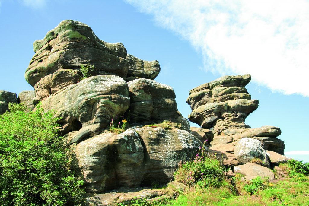
In this feature, Brian Spencer takes a nostalgic visit to one of the strangest geological features in Britain. Currently out of bounds during lockdown, it is somewhere Brian plans to revisit once freedom of movement is available. Brimham Rocks, sometimes called Brimham Crags are a group of strangely eroded millstone grit rocky towers high above the western edge of a183.9 hectare (454 acre) moorland escarpment overlooking Nidderdale, 8 miles (13km) north west of Harrogate. Such is the importance of the site that it is classed as an Area of Outstanding Natural Beauty. Along with the rocks, the surrounding moorland is home to semi- rare wild creatures and acid loving plants, all living in and around birch woodland on a large unspoilt area of both wet and dry heath. The major attraction to the site is its strange water and weather-eroded rocks, which were formed over many millions of years from sediments laid down in a huge river delta. Subsequent earth movements and ice and river erosion left an escarpment high above what became the River Nidd. The escarpment splintered into rocky towers over the millennia which, in turn separated into inter-connected boulders and rock faces. During the mid-seventeen hundreds an interest developed in what was called New-Druidism. Manmade rock circles and other unusual rock features in the landscape were considered to be the work of druids. Brimham Rocks became the venue for many of the philosophical thinkers of the day, who wrote quasi-serious essays following their visits to Nidderdale. In line with the then current ideas, they gave fanciful names to many of the rocks; they came up with names such as the Druid’s Idol, Druid’s Altar and Druid’s Writing Desk which have lasted into modern times. Brimham Rocks are formed from a semi-coarse sandstone laid down in the later part of the Carboniferous period in what became the Pennines (rocks on Kinder Scout were similarly laid down around this time). Due to the sands being deposited in moving streams which changed direction from time to time, it resulted in cross-bedding. This is very evident in most of the Brimham outcrops. Weathering in the Ice Age and windblown sand even now has led to the weaker and harder strata weathering at different rates; this resulted in the towers’ weird and fanciful shapes. We prefer to travel up to Brimham Rocks by way of Skipton and Pateley Bridge a few miles to the north along Nidderdale. Being on an old coaching road, the village is well appointed for cosy pubs and interesting shops – it even boasts having the oldest sweet shop in the country. True or not, being sold toffees from a glass jar takes us oldies back a few decades. Pateley Bridge was even once connected to the railway network. For a long time it was the terminus of a branch line from Harrogate, left over from a railway laid to supply building materials to three reservoirs being built towards the head of Nidderdale. From Pateley Bridge we took the steep road climbing the east side of the dale as far as a cross roads at Low Laithe. From there a left turn joins an even steeper road thoughtfully signposted to Brimham Rocks, our destination. Turning into the car park we got our first glimpse of the wonders to come. Rather like something out of a John Wayne cowboy movie, piled boulders and rock towers beckoned from the surrounding dwarf silver birch and a friendly National Trust attendant pointed out the start of a little path that winds through the trees up to the first of the named rocks. While many of Brimham’s druidical rocks were named by antiquarians in the eighteenth century, others have more fanciful names given to them by caretaker guides based at Rock House in the centre of the moor in order to attract paying visitors. Our first contact with named rocks came quite soon after walking along the narrow path diverging from the central track leading to Rock House. Part of a long sinuous escarpment of broken rocks it is the Surprise View over-looking the length of Nidderdale far below. This was just a taste of things to come and we followed them to a rock tower with a perched dog-like stone called inevitably, the Watchdog. Not all the rocks have ‘official’ names and we soon began to enjoy ourselves by inventing names that fulfilled our imaginations. The one I spotted was a perfect rendering of a cartoonist’s version of the late Prime Minister Margaret Thatcher MP. Named rocks begin with the Watchdog, but the most modern and arguably the best is the Smartie Tube; here we swung round through isolated outcrops, all the time wondering what it would be like to explore the moor in thick mist or a snow storm. Thoughts of a Sherlock Holmes adventure came to mind or some-thing out of a Hammer Horror film would revel in the unusual setting. The path, fortunately in glorious sunshine, led us back towards the central track, stopping first at an area called the Cannon Rocks; why this is so I am not sure, but the next outcrop across the track, is called the Blacksmith’s Anvil and is easy to find because of that. All the paths seem to join at the bottom of a hollow where the Eagle and Castle Rocks hold sway. That was until a bunch of hooligans bounced the rocker out of balance. To their right the Flower Pot and Oyster Shell seem to be the result of a gardener with a vivid imagination. The space beyond opens out to offer somewhere to rest and enjoy a little refreshment. Rock House, now a Grade II Listed Building once a hideaway for sportsmen harassing the moorland grouse and occasional wild deer is now the Visitor Centre from where in better times guided tours of the rocks are on offer. Immediately to the left of the Visitor Centre, the Dancing Bear stands proud on his rocky plinth.
Walk Derbyshire – Elton & Gratton Dale

This walk explores one of the lesser known parts of the White Peak. Properties in Elton where the walk starts, would be easily recognised by any returning inhabitant, even after the passage of long forgotten centuries. At one time there were two villages, Gratton as well as Elton, but following an outbreak of the Black Death plague, Gratton was abandoned, eventually reappearing as a scattering of small cattle and sheep farms clustered around a dairy specialising in the production of a unique crumbly white Derbyshire cheese. Many of the farms in and around Elton were rented by part-timers who divided their above ground activities with small-scale lead mining. Their activities can still be traced from the numerous spoil heaps and capped-off access shafts dotted around nearby fields. As the price of wool declined in recent years, dairy farming became the major activity, with Oddo House Farm on the west side of Elton running the largest herd. It is many years since local milk was sent down the hilly lane to Gratton, there to be made into cheese; the abandoned dairy now serves as a well restored domestic dwelling and holiday let. Starting near Elton’s quirky pub, the Duke of York, the walk follows a field path which skirts an abandoned Saltway between Ashbourne and Bakewell. It was diverted eastwards when Elton Common was enclosed. Ancient footpaths lead to the mother church in Youlgreave, but the oldest track by far is the Portway about half way between Elton and Winster. Prehistoric in origin, it can still be traced locally where it crosses the valley of Ivy Brook below Birchover; aiming for the crags of Robin Hood’s Stride, it passes a hermit’s cave marked by a simple crucifix carved into the rocky shelter, the path continuing below on its long way between the River Trent and Mam Tor. After crossing the enclosed fields of Elton Common to reach Gratton Dale, this pretty dale is part of the cluster of dales and limestone moor forming a Site of Special Scientific Interest (SSSI). The dale is a natural habitat for semi-alpine plants and wild orchids. Muddy in places the path follows a route beneath a ruined lime kiln towards Gratton, another link with one of the local industries. At the dale end, the path joins a narrow lane running past the Old Cheese Factory. Here a right turn beyond the lime kiln links with a short climb which returns to Elton, passing the village church with a copy of its unusually designed font. DIRECTIONS : 1.From the church, follow Moor Lane opposite, for about 200 yards beyond the Duke of York pub. If the church is open, call in to see the font. This is a copy of the original one left outside when a new church tower was being built following damage caused by lead miners working too close to the foundations. The original font is now in Youlgreave church, and Elton’s copy is a faithful rendition of the Saxon original. 2.A little way beyond a de-restricted speed sign near the turning for Back Lane, leave Moor Lane by turning right into a farm track. It is not uncommon for field access tracks to be named locally, but this one is a rarity because it has a metal street nameplate just as if it were a busy town street even though there are no houses along its length, just being a way to the fields on Elton Common. The name of the track in this case is Hungerhill Lane (sometimes also known as Ongrill) 3.Follow the track for a few yards as far as a stile next to a finger post. Turn left here and follow a field path across a series of fields for about a mile. The ivy covered ruin to the left of the path near its start is all that is left of Dawson House where the local lead agent lived in the 18th Century; lead agents bought ore from local miners, but were not always too popular as they could not be guaranteed to give the best prices. Using gates and stiles to keep to the line of the path, continue until you reach an overgrown track. Cross this by way of stiles and continue forwards across yet more fields, keeping to a straight course until the main road is reached. 4.The path has reached the Winster/Newhaven road at its junction with the A5012 Cromford/Newhaven road. Go through a stone stile, turn right and follow the grassy verge for about 150 yards. 5. When Mouldridge Grange Farm comes into view to your right and below, look for a narrow stone stile in the wall again on your right. Go through it and follow the boundary wall, straight at first, then curving left behind the farm. The word Grange in the title for Mouldridge Grange Farm indicates that it was once a monastic farm or grange. In this case it was owned by Augustinian monks of Dunstable until the sixteenth century dissolution of the monasteries by Henry VIII. 6.Bear left and then right and go downhill into Gratton Dale. Turn right to follow the dale as far as its junction with the Elton to Youlgreave road. Gratton Dale is part of a Site of Special Scientific Interest (SSSI), well known for its limestone loving flowering plants and field orchids. Where the dale-bottom path joins a farm track coming from the right by a gate, look to your left. The wide horizontal hole in the hillside is not a mine, but the lower part of an abandoned, but well preserved lime kiln. Locally quarried limestone would be burnt here to create lime for spreading on fields in the area. The hamlet of Gratton is a pleasant cluster of farms and restored cottages. It is well worth exploring. To your left the second building along is the old cheese factory. The factory is now a popular holiday let, but it was once the source of an excellent
The Village of Elton – A Journey Through Time

Even though prehistoric travellers following the Portway from the Trent to Mam Tor would have passed through the area, modern Elton can be overlooked. Being off all the through roads crossing the limestone uplands of the Peak, it is easy to ignore, but as a Michelin Guide might say, ‘it is well worth the diversion’. The village lies about half a mile in any direction from the B5056 Cromford to Bakewell or the Winster to Newhaven roads and a turn off either leads down to Elton village. Home for many years for the lead miners who sought the scant riches from beneath local fields, Elton has existed in one form or another for at least 5,000 years, but its first official record was in the Domesday Book when 18 families made their living from farming the upland pastures. The village took its name from the first recorded farmer Aelfwine, better known as Ella who developed his ‘tun’ or small farm here around the 8th or 9th century. Over years, Ella’s tun became Elton. The first settlers who followed Ella built farmsteads along Well Street where there was a small spring. This joined what became Main Street connecting Winster road, where a church was set up on the north side and a pub, the Duke of York to provide refreshment diagonally opposite. Of course all this took time, but gradually a village of pleasant stone cottages spread along Main Street and Back Lane to its south. Most of these properties became farm labourers’ homes, many of whom combined farming with part-time mining. The best place to start any exploration of Elton is from its church. The present church dedicated to All Saints dates from the early 1800s, replacing a much older medieval chapel whose spire collapsed in a storm. It is thought that it had been weakened by miners illegally digging too close to its foundations when following a potentially rich vein of lead. A curious story links Elton church to Youlgreave’s, or at least its font. Dating from Saxon times, Elton’s font with its attached stoup to hold Holy Oil was dumped outside the church by workmen when the place was being renovated. Once the new church was ready, no one thought about taking the font back inside and it slowly began to disappear beneath the weeds. In the next part of the tale Youlgreave’s curate happened to spot the font lying there un-appreciated. Youlgreave must have been in need of a new font for without due ceremony it was moved from Elton and to this day holds pride of place near Youlgreave’s door. Elton folk then realised their loss and asked for their font to be returned, only to be told ‘sorry, it’s ours now’, or words to that effect. All that Elton could now do was to have a copy made by local masons. Lead miners held the belief that beer cured lead poisoning, if they were around today they might have to give the Duke of York inn a call. The pub, standing across the road from the church once had some rather odd opening times, but nowadays it is open most evenings and lunchtime on Sunday. The pub, a Grade 2 listed building, has kept its name and character for over 200 years and is a perfect example of a rural English hostelry. At one time there were two more pubs in Elton to slake miners’ thirsts. These were Nelson’s Arms and the Red Lion, but only the Duke of York has stood the test of time. Before setting off to explore the main part of Elton, it is recommended that visitors start at West End part of Main Street and walk downhill as far as Gratton, Elton’s next door neighbour. Before Elton’s fields were enclosed, allowing stock to wander at will, a small field on the right was called the pinfold. Here strays were held until their owners paid an appropriate fine. Elton’s major farm, Oddo, fills most of the land to the south of West End. Today, following the gradual amalgamation of most of the farms in the district, there are now only five, mostly concentrating on milk production. Dairy farming has always been an important part of the local economy and at one time there was a cheese factory producing light, crumbly white cheese. No longer is Derbyshire cheese made at Gratton, but the building has been tastefully converted into a private house and holiday let. Anyone remembering the ITV series The Mallan Streak, will have seen the cheese factory prior to its conversion. The then abandoned building masqueraded as a wayside inn and for several years its sign tantalised unwary passers-by in need of a drink. Back uphill to the church, the main part of the village is roughly triangular in shape, spreading east on both sides of Main Street. Two short lanes, Stone Foot and Ivy Lane connect with Back Lane to the south overlooking nearby grazing. More houses surround the church, running north along Well Street and Joule’s Croft. A few modern houses are built on both sides of Main Street at its eastern end overlooking the village sports and recreation ground. Most of the houses in and around the centre of Elton date from the seventeenth and eighteenth centuries and are probably built on older foundations. The following notes cover just a fraction of the oldest and most interesting buildings squashed in cheek by jowl in a delightful mix of styles, but most have been built with locally found stone, mainly gritstone from Birchover Quarry across the valley. From the top of West End, the steep road up from Gratton passes a mix of older type properties along with a scattering of bungalows owned by Dales Housing. Moving up into West End, the substantial double-fronted Lawson Cottage was a privately run dame’s school dating from the 1870s. Turning left into Well Street, the Old Rectory was built in 1838 and was the birthplace of Rhoda Garrett
Lost Houses of Derbyshire – Stretton-in-Shirland

It is entirely through the thorough researches undertaken by Gladwyn Turbutt that we have a good, comprehensive history of this lost house and its occupants. Derbyshire historian Stephen Glover wrote in around 1832 that the house overlooked ‘one of the finest valleys in the county’ and if you were to go to our excellent Museum at Derby you will see Joseph Wright’s painting The Rainbow, which is understood to have been painted by the river Amber just below the house which, in its heyday, was set in a small park of unusual beauty. And indeed, Joseph Wright had strong connections with the house (as he had with lost Yoxall Lodge in Staffordshire through his long friendship with Derby’s slavery abolitionist Thomas Gisborne). When I wrote about Derwent Hall, we encountered a house that was lost to the building of a reservoir, and Errwood Hall was also a secondary casualty in Derbyshire of a house lost to the desire of local authorities to flood valleys of incomparable beauty to quench the thirst of the citizens of adjoining towns. Regrettably, Ford House and its predecessor, Ford Old Hall (or House), were also casualties of this ecologically unfriendly aspect of having to deal with a burgeoning population. Some time in the Tudor era, a family called Curtis held a modest estate at Ford, but they enjoyed the status of yeoman farmer rather than of gentlemen. In the seventh century John Curtis married a daughter of their near neighbours, the Revels of Ogston Hall, subsequently became a Quaker and in 1680, with the encouragement of a Revell kinsman, migrated to America where his progeny still flourish. The Curtis family must have built the old hall, a single range of which survived into the twentieth century, and which was the subject of a postcard issued by a local firm at Alfreton. What one sees is a lowish two storey range of coal measures sandstone with two light mullioned windows set with cast iron casements and topped with a stone slate roof. To the right was a later range, and the whole functioned as a farmhouse until it met its nemesis. Swathwick, in Wingerworth, who initially added the range to the right of the Old Hall around 1700, allegedly as a malthouse, although the formality of its architecture rather suggests increased accommodation for Holland who had married three years before. Yet he was a maltster, and a successful one, but one feels that the epicentre of his trade would more likely have been in Alfreton, three miles away. In 1713 George was succeeded by his son Thomas, whose accounts partially survive, entries from which suggest that he spent £100 building stables in 1721 and a few years later spent £336 for ‘building the house at fford’ which is usually taken to be the Ford House that survived to be photographed. Yet there are reasons to doubt this. The three photographs I have been able to dig our (three of them locally printed postcards) show the house as a three storey stone building, of coal measures sandstone, ashlared to the main (east) front and of random rubble brought to course at the sides. It had a hipped roof, a cornice supporting a dwarf parapet and three bays of paired sashes to the main façade, a most unusual arrangement for the date. The pediment at the centre of the ground floor was clearly not intended as the main entrance, as it spanned two bays like the rest, of which only one serves as a door, almost certainly to give access to the garden. The entrance was clearly in the courtyard behind and to the left. To the left too there is a single bay of superimposed paired mullioned but sashed windows, roughly the same height as the main range and beyond that a courtyard connecting to a very pretty stable block consisting of a pediment over a triple arcade. The main house is most emphatically not in the style of George I, nor is the stable block for that matter. Looking at the two storey range to the left (the south wing) I suspect this is all that was suffered to remain after a later building campaign, of the original house, possibly a rebuild of an earlier building (Mr. Turbutt suspects that earlier stable block of the Old Hall which stood behind to the north). This remnant, latterly the kitchen wing, included an inscribed pane of glass to ‘Thomas Holland de Ford in Com. Derb. Gent. Decimo Quarto die Aprilis Anno Dni 1729’ This must surely be a commemoration of the completion of the building, for which the £336 payment was part. What was there latterly looks remarkably like a late eighteenth century house, although the paired windows are still a rare feature. Furthermore, the stables look a little earlier if anything; the arcade under a plain pediment closely resembles the summerhouse built by Joseph Pickford at Ashbourne Mansion around 1763 and in the early nineteenth century was embellished with stone balls to the gateway and wall in true Palladian tradition, these details known only from a contemporary painting. Finally, although the 1720s accounts break off, incomplete, £336 for a substantial house (unless a payment on account) is not a lot of money. Thomas Holland died in 1776 and, I suspect, at a much later date than his youthful building programme, he had the stables enlarged and embellished, probably in the 1760s, using an architect not unfamiliar with Palladian motifs, perhaps Edmund Stanley of Chesterfield, who oversaw the building of the new hall at Ogston nearby to the designs of Joseph Pickford of Derby. Thomas was succeeded by his son John, an altogether more sensitive man than his father. He married in 1777, his wife Mary being sister-in-law to his equally cultivated neighbour William Turbutt. The couple entertained at Ford an important network of enlightenment friends including painters like Wright and his friend William Tate, the abolitionist and collaborator of William Wilberforce, Revd. Thomas Gisborne and
Alison Uttley’s Cromford – then & now
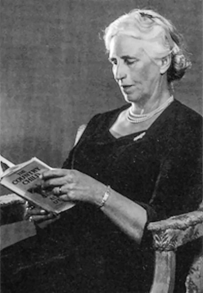
In the 1930s, countryside author Alison Uttley wrote a series of short essays based on her childhood experiences in and around Cromford. These were later produced in book-form by Scarthin Books. Currently out of print, it is possible to find a much-cherished second hand copy; armed with one of them, Brian Spencer looks for what became of the shops and businesses that once cared for the everyday needs of people living in Cromford over a century ago. Alison Uttley was born as Alice Taylor, on December 17th, 1884, at Castletop Farm, between Cromford and Lea Mills. A highly intelligent girl, she began her academic career by winning a scholarship at Lady Manners Grammar School in Bakewell. From there she went on to study Physics at Manchester University, taking an honours degree, one of the first women to enter the field of science. Following a teacher training course at Cambridge, she taught Physics and English in Fulham for three years before coming back to the North of England after marrying James Uttley. Moving to Buckinghamshire where she spent the rest of her life, her writing career began in 1931 when, as a widow she had to support herself and her infant son. Her first book was ‘The Country Child’, an autobiographical novel based on her early life as the daughter of a farming family. This was followed by much-loved children’s stories such as ‘Little Grey Rabbit’ and ‘A Traveller in Time’ and many other novels and plays, some of which have found their way on to the small screen. Although she never returned to Derbyshire, she began to write about her early experiences in and around Cromford. Here she would go by pony and trap with either her father and mother, or just the one, in order to buy their everyday needs, or have repairs made to the horse’s harness, or maybe watch while the farrier fixed the pony with a new shoe. Cromford in her time and well into the twentieth century, was a completely self-supporting village. It really did have the traditional Butcher, Baker and Candlestick maker, along with draper’s shops where Alison and her mother could buy a new bonnet. Her father could be measured and fitted with a new suit, or buy medicines for a sick cow. There was even a cobbler and a wheel-wright, in fact everything a busy village attached to Sir Richard Arkwright’s thriving cotton mill would need. Armed with a copy of the village map (see below), we soon discovered that while none of the businesses Alison or her parents relied on still exist, most of the buildings are still there sheltering other commercial interests, or even converted into private houses. Though the businesses have changed, the village is still laid out as it was in her day, and so our trip round Cromford was easy to follow. We started our walk round Alison Uttley’s Cromford with a late breakfast at the quirky wooden café that stands on the corner of Mill Road, above Arkwright’s Mill, where many of Cromford’s inhabitants made their living. Very little has changed with the café building apart from its use. In Alison Uttley’s time it was a barber’s shop, a place where the local men could socialise. Taking our lives into our hands we crossed the A6 and began to follow the left side of Cromford Hill Road. Beyond the small war memorial garden, the first building on our left is the Community Centre built on the site of the local flour Mill. A ladies’ hairdressing salon shares one corner, using what was once the village blacksmith’s place of work. Beyond a narrow gap a chip shop and cafe (one of two chippies supplying the village), fills what was once a post office, then comes a private house where there was a pork butcher’s shop, then later a bank. Beyond it Arkwright’s Store struggles against changing grocery needs, but next to it is probably the only unchanged shop in the village; this is the village newsagents where young Alison bought her penny dolls. Moving on up Cromford Hill, the next shop of interest comes next to a narrow drive accessing a group of cottages. This was where Alison and her mother bought ribbons to rejuvenate their hats. It later became a dress shop, but now looks after the requirements of the areas plumbers. Stone built houses line the road in a mixed selection of styles, many of them include a stocking frame knitter’s workshop in their upper stories. These cottages continue up to and beyond North Street, the street and school built by Richard Arkwright Junior to provide accommodation for his workers and stocking frame knitters. The street is built to give each side a fair share of sunshine, the north in the morning and south in the afternoon. Two commercial buildings stood at the entrance to North Street; on the left is the elegant bow front of what was once a butcher, but is now a private house. The Bell Inn is opposite, having partly extended into the grocer’s shop, once its next door neighbour. If anyone who lived lower down the hill wanted a loaf of bread they would have to climb to what is now the next door neighbour to the Bell, for that is where the village baker worked. Returning to the bottom of Cromford Hill, Water Lane carries quarry traffic along the Via Gellia. At the lane’s junction with the hill road, a general merchant uses part of the old carpenter and wheelwright’s workshop. An Aladdin’s Cave it fulfils D.I.Y needs and everything from sledges to wrought-iron display stands. It would have been well known to Alison’s father. Moving along Water Lane, past the closed Co-op shop that came and went after Alison Uttley’s time, the pond on your right gave power to Arkwright’s early mills. It also collected water draining from local lead mines: this was collected via a complicated system of channels behind the houses and shops at
Celebrity Interview – Rachel Swann
Update – February 2026 Derbyshire’s first female Chief Constable has now officially announced her retirement. We have published full coverage of the announcement, including key dates, career highlights and reaction from across the county. 👉 Read our full retirement coverage here:Rachel Swann announces retirement as Derbyshire Chief Constable (2026) ————- It’s a situation only a select number of people have experienced: waiting for the Prime Minister to ring. The circumstances in which Rachel Swann was preparing to address Boris Johnson were certainly unusual: she was responsible for the largest peace-time evacuation of civilians in the UK in the hope of averting an unparallelled disaster. At the time Mrs Swann was Derbyshire Police’s deputy chief constable and in charge of the operation to move 1,600 people from Whaley Bridge after the dam at Toddbrook reservoir began to collapse. As part of her duties she had to brief the Cabinet, chaired by a government minister, at daily COBRA meetings – a committee that takes action in national emergencies. “It was an odd moment waiting for the PM to ring you on your mobile,” says Mrs Swann. “The PM called me on the Friday morning – the day after it all happened, offering his support and asking me what we needed. “The COBRA meetings were very helpful in terms of making sure our response was joined up and in helping ensure we had military support. I have to say the military were brilliant throughout, as you’d expect.” Mrs Swann is now the Chief Constable and the first woman to hold the position in Derbyshire. In August last year, the media around the world reported how she managed more than 2,000 people including fire and rescue workers, the armed forces, the county council’s emergency planners, ambulance staff and flood rescue teams as a catastrophe was avoided. But she points out that the collapse of the reservoir wasn’t a question in her interview. “What I would say is that the incident helped me to demonstrate my leadership in a crisis. It very quickly meant I built up good partnership relationships in a short period of time. “As a force we saw just what we could do in a crisis and there were many individual acts of bravery and commitment to keep people safe. “This was a large operation and the lessons learned have been extensive. This has been extremely helpful in how we’re dealing with the Covid-19 challenge.” While she was widely praised for her handling of the rescue operation, others took a different view: she was targeted on social media with misogynistic and homophobic slurs, mainly because of her hair. She has a quiff which is spiked up and dyed blonde. At the time she said what really hurt was the people who said she had no standards and was letting policing down. But a number of people defended her, including Councillor Barry Lewis, the leader of the county council, who said: “Be under no doubt: she saved a valley. That’s what’s important.” It led to her taking a break from Twitter. But Mrs Swann points out that social media has many positive aspects. “It enables you to reach many people that you wouldn’t do normally, on a much more regular basis. It allows our teams to tell people what we’re doing about local issues which is really important. “We also found in Whaley Bridge it was invaluable: we used the police account as the one source of accurate information and could effectively deal with rumour and speculation before they caused unnecessary fear. “But it does have a downside as people ignore normal, polite rules of conversation and use it to criticise in a very unrestrained way. “It was a surprise to me just how many negative comments I had and how much momentum it gained. But I’m more prepared for that now and make sure I minimise my exposure to it.” She also realises how digital technology is “critical” in making the force more adaptable to change, working more efficiently and tackling criminals. “We know that fraud and other offences are moving online and there’s a concentrated focus in forces across the country to disrupt, detect and pursue those responsible – and to help protect people in their online lives.” Rachel Swann is 49 and was born in Cornwall. She did not consider the police as a career after a police officer went to her secondary school and put her off because he said she was too small. After graduating at Loughborough University she worked in a gym. A friend said she was applying to join the police and Mrs Swann learned that the height limit was no longer in existence. She thought she might give policing a go “as it appeared to be a good, interesting career with lots of opportunities”. She was still living in Leicestershire, so she joined that county’s force on its graduate entry course as a PC in August 1994. She stayed there for 20 years and looks back on it as an enjoyable time. “I’ve benefited from quite a diverse career and worked in both the rural and urban parts of the county. I’ve also worked with some really fantastic people, which makes all the difference. “I really enjoyed being head of specialist operations – I was responsible for roads policing, dogs, firearms, public order, etc. That was the role I really wanted and I was fortunate enough to get it in 2010.” Her proudest moments were working with Team GB’s Olympic training camp at Loughborough University and being involved in the Queen’s visit to Leicester as part of her Jubilee celebrations, both in 2012. Three years later she went to Northamptonshire as assistant chief constable, becoming deputy in 2017. She arrived in Derbyshire in February 2019 as deputy chief and in August 2020, after 26 years’ service, she landed the top job. Mrs Swann has a number of priorities: “It’s really important to me that we deliver a good service consistently, one which our communities trust.” Other