Places Pevsner Forgot by Maxwell & Carole Craven
We supposed that Sir Nikolaus Pevsner missed Horsley Woodhouse because he probably travelled north along the Derby to Heanor road, and was thus able to enjoy Smalley, and on another occasion doubtless journeyed south west from Denby towards Coxbench (neither of which he missed) passing by Horsley Woodhouse at Four Lane Ends where that road crosses the Smalley to Kilburn Road (A609), upon which, straggling along a ridge, Horsley Woodhouse lies. Indeed, the ridge is relatively high and gives a superb view north towards Denby and indeed Ripley, and a less spectacular but more charming one into the shallow valley of Gipsy Brook running parallel to the south, in a vale called locally Golden Valley. One hundred and fifty years or so ago, it would have looked a lot different however, for Horsley Woodhouse was then a small mining settlement, coal mines, many of them adits, driven horizontally into the hillside rather than vertically downwards. Indeed, coal extraction probably accounts for the original settlement, first recorded as Wudehus in a fine of 1225 and as Horselewodehus in the patent roll for 1303. ‘Woodhouse’, essentially means the ‘house in a wood belonging to [the manor of] Horsley’ in which parish it lay until 1878. This house was probably later the residence of William de Stainsby, who settled there by inheritance at the east end of Golden Valley in around 1328. His house later became Stainsby House, the occupants of which, latterly the Wilmot-Sitwells, were local coal owners until the first part of the twentieth century. Indeed, the coat-of-arms of their predecessors the Fletchers, were adorned with miner’s dials, to advertise the source of their rise in status into the landed gentry! Driving along Main Street, one might be forgiven for dismissing the place as a rather dreary collection of 19th century miners’ cottages. Whilst this is to some extent true, there is much to enjoy in them and more so scattered amongst them. It is not easy to find a safe place to park, so we chose the car park of the Old Oak, situated about half way along on the north side, a pleasant stuccoed early 19th century building built in two phases, and recorded as a pub only from the later 19th century. Being reasonably responsible people, we called to refresh ourselves and asked the landlord if he would mind if we had a wander before returning for the car, to which he raised no objection; after all, it was a quiet day in mid-January. Thus fortified, we turned west, toward Four Lane Ends. Noting the stunning views to the north from a lane beside the pub. Here the houses gradually become early twentieth century although there are a few older ones, including an oddity, No. 121 (south side) a Victorian three bay villa turned into a bungalow with its first floor removed (perhaps after a fire?) but still displaying Flemish bond brickwork and a fine stone front doorcase. The semi-detached former council houses on the north side are well designed and matured well. The only interesting aspect of the village here is the Roman Road, Rynkneild Street, about the course of which we wrote in Country Images some years ago. This runs north-south here and is marked by a hedgerow to the north, but from the road only by the oddly off-line western boundary of No. 216. To the south, a track called Golden Valley (worth exploring if only for the glorious countryside) runs off parallel but it is otherwise not readily apparent, although also parallel to it to the west is a once fine terrace of cottages called Horestan Place, much marred by later alterations and ‘improvements’ but probably a lot easier to live in for all that. Returning eastwards, past the very useful Co-op, back past the pub, we noted No, 94 (south side), another cut-down former three storey dwelling, probably of around 1790 with posh lintels and keyblocks but again, reduced by a storey and even then, the surviving first floor has been further diminished in height. It suggested to us that the emphasis of the village economy had changed from a preponderance of agriculture and framework knitting to an increased mining population from c. 1800, causing houses to be reduced and in one or two instances subdivided into smaller cottages. Yet the age of this house did suggest that we were entering the original core of the village and immediately, on both sides the cottages are terraced with doors opening onto the street. Just beyond these on the left is a pretty impressive Arts-and-Craft house, 1920s rather than Edwardian, representing another of the settlement’s pubs, this time, long closed. This began as a beerhouse, the Knife & Steel, in the 19th century, but this ambitious rebuilding must have marked an attempt to go up-market – but to no avail, for it had closed for ever by the outbreak of war, to be converted into two houses called – inevitably Knife and Steel. Just beyond, we found Fairfield Road running downhill to the north, a chance to discover what delights might lie behind the main drag. We were not disappointed, for beyond further mid-19th century and later miners’ cottages and a post-war estate, we encountered The Crescent. Situated at virtually the lowest point we found what is surely the oldest surviving building in ‘’Ossly Woodus’: a stone-built cottage with much altered fenestration – amazingly un-listed. This was built, presumably in the 17th century (or earlier) and was for many years the Old Knife and Steel, prior to being re-named the New Inn, when its name migrated to the pub on Main Street. The building is dated 1672 on a chimneypiece, the front door and upper windows have been neatly blocked and an extension added: a very attractive ensemble, again with wonderful views from the rear. Further along Main Street, a plethora of new walling and gate-piers marks Willow Grove, an early Victorian villa recently rebuilt almost out of recognition, but the local doctor’s
The Lost Houses of Derbyshire – Culland Hall

by Maxwell Craven It is perhaps quite a stretch to envisage the sheer antiquity of the site of Culland Hall, were you to visit the place today, the splendid gardens which are occasionally open to visitors and which are well worth visiting. Indeed, the present house is an agreeable neo-Georgian brick mansion, much in the later style of Sir Edwin Lutyens, and was built for the late Col. Sir Edward Thompson (1907-1994) – of Marston, Thompson & Evershed, brewers of the incomparable Pedigree ale – in 1939-41 to the designs of George Morley Eaton PRIBA of Derby who indeed died in office whilst building was going on. These works, however, necessitated the demolition of the previous house, by then apparently exceedingly dilapidated, having been in use for some generations as a farmhouse. The place gets its first mention in a charter of 1220, when it was granted to Nicholas de Caveland, second son of Henry de Osmaston and grandson of Eutropius of Brailsford . Thus, both Eutropius’ son and grandson had taken their surnames (then something of an innovation) from the place settled upon them by inheritance. Eutropius, in turn, descended from the Domesday tenant, Elfin (correctly Aelfwine), one of the few Anglo-Saxon grandees to retain their estates through the upheavals of the Conquest. And, of course it tells us how the place name Culland was rendered in the 13th century: Caveland, meaning ‘the land of Cufa’, an attested personal name, and presumably a long-forgotten pre-1066 owner, seemingly of Norse descent. This family continued there for a couple of generations and, one must assume, built a capital mansion, for which no direct evidence survives, although a moat was traceable in the 1930s, a short way from the present house. This modest estate had passed by 1380 to the Montgomerys of Cubley, then a very powerful and influential family, and was settled on a younger son, Thomas, who was recorded there also in 1401. Some time prior to 1470, the estate and presumably the ancient house, was sold or passed by inheritance to the Shaw family, whose origin is not clearly understood, and remained with them until 1497 when Thomas Shaw died. His successor was his brother, Robert, who was disbarred by being a lunatic: people with mental disability were in those days deemed incapable of administering property and were thus prevented from inheriting by statute. Thus in 1519 after a number of lawsuits, the heiress, Joan, brought the estate to Sir Ralph Shirley of Brailsford, Shirley and Staunton Harold, upon whose younger son Francis it was settled, only for him to dispose of it, before 1600, to one James Draper. The heralds’ Visitation of Derbyshire tells us that he was previously of Dockenfield, Hants., although in reality, this village is in Surrey, nearer to Farnham. The 1634 heralds’ visitation of the county informs us that arms were borne without authority and that his wife was Mary, daughter of a former London pewterer living at Bradley called John Morrey; the 1662 Visitation, contrarywise, calls her the daughter of the somewhat grander John Merry of Barton Blount. Whoever she was, they had a son called Thomas who died in 1646 leaving, by Dorothy, daughter of Robert Port of Ilam, two sons and four daughters. The eldest son was Robert (1625-1689), and he is reputed to have built a new house, of which the stable block survives, albeit extended and slightly altered in the nineteenth century. It is of red brick with Keuper sandstone dressings, gables decorated with small ball finials, flush quoins, oeil-de-boeuf windows and a plat band, now listed grade II. We may safely assume that the new house was similarly constructed and was probably a gabled, E-plan house with end gables flanking a central two storey gabled porch. It was assessed on 6 hearths in 1664, so it was only of modest size. Robert Draper married Elizabeth, daughter of Richard Harpur of Littleover Old Hall (see Country Images of June 2014) but there were no surviving children and on his death his brother Thomas, a Coventry businessman, was passed over (or had died without issue) and the youngest daughter Prudence, succeeded, having married George Newall of Windle Hill in Thurvaston. It was in his rime that William Woolley described the house in 1713 as ‘a pleasant seat – a small manor on a hill about one mile south west of Brailsford….and pretty good enclosed land.’ This period also saw the drawing of an estate map by the ubiquitous Thomas Hand (dated 1709) showing the house with two storeys and attics and three gables, all facing south west across a small park with a miniscule lake, still discernable on the 1922 6 inch OS map. The estate then ran to a modest 4191/2 acres. A generation later and George Newall had sold the estate to his cousin John Port of Ilam Hall and in 1794, the whole lot was sold to Derby lead trader William Cox of Brailsford Hall (builder in 1809 of the Derby shot tower), whose family owned it from then until the end of the Victorian era. Cox, a great improver, decided that the house should henceforth be run as a tenanted farm as part of his Brailsford hall estate (see Country Images April 2019), and decided to reduce and extensively rebuild the hall again, early in the nineteenth century. He re-orientated the main part of the house, providing two brick parallel ranges running east-west with gabled ends, stuccoed, and leaving only one range of the older house which, oddly, was retained and, being orientated SE to NW, gave the post-rebuilding plan a rather odd look. The new south front was given superimposed Regency tripartite windows flanking a central pedimented entrance with a single sash above. There were lower extensions to the east and west, that to the west being very much lower, probably older, and was presumably a service wing. The stables lay behind, with other ‘model’ farm buildings provided to the north, now amply
The Lost Houses of Derbyshire – The Grove, Darley Dale

The name Alsop (with multitudinous variations of spelling) is by no means uncommon in Derbyshire, if only because it derives from an unique place name, Alsop-en-le-Dale, next to Parwich, just north of Ashbourne. The Alsops had a Norman or Norse ancestor, called Gamel (probably derived from the Latin for ‘twin’- gemellus), who took his name from the place when granted the sub-tenancy of the manorial estate there by Henry de Ferrers before 1086. His descendant remained there until poverty forced a sale in the late 17th century and a tall portion of the family’s Elizabethan house remains as an ornament to the village to this day. As the place name is unique, it is likely that all Alsops today descend from Gamel, although you would need to DNA test everyone bearing the name to establish that most were actually of the same blood, so to speak. Furthermore, the preservation of the uniform spelling of names was in the hands, before the 1870 School Board Act, of semi-literate parish clerks which is why many surnames have sometimes quite extraordinary phonetic variants. With the Alsops, it rested with the duplication or otherwise of ‘l’s and ‘p’s. Hence, TV personality Hon. Kirsty Allsopp and her ancestors, back to Derby tobacco merchant Thomas, all spell with two of each. When her ancestor, Sir Samuel Allsopp, Bt., 1st Lord Hindlip, was first ennobled, he wanted to take the title Lord Alsop of Alsop, but he failed to establish his descent from the ancient family, and the Heralds in 1886 refused and whilst such a descent seemed likely, lack of proof forced him to take the name of his Worcestershire country house, Hindlip Hall (now the West Midlands Police HQ) as his title, becoming ‘Lord Hindlip of Hindlip and of Alsop-en-le-Dale’ (of which parish he had thoughtfully acquired a modest amount of land). He also had to accept changes to the historic coat-of-arms. Back in Derbyshire, lead trader John Alsop of Snitterton who wrote his will in 1798, was a similar case. His descent, possibly from Luke Alsop of Wirksworth, living in 1693, cannot be provably traced to Alsop-en-le-Dale either, although for all his family’s skyrocketing wealth, he was never offered a peerage! John Alsop had two sons, the elder Anthony, was barmaster (legal controller of lead mining) at Wirksworth and was ancestor of the Alsops of Wensley Hall, three generations of whom were barmasters at Wirksworth. The younger son, John Alsop was a lead merchant like his father and settled at Lea Wood, dying there in 1831; his memorial still graces the wall of the former chapel there to this day. He had two sons and two daughters, of whom the elder son Luke lived at Lea Hall, a delightful Baroque villa (albeit facing the chilly north winds) high up in Lea, and married Lydia the daughter of his father’s brother Anthony. The house at Lea Wood stayed in this branch. The younger son was John who was also a lead merchant and acquired some land on the east side of the main road (now the A6) through Darley Dale. Here, about 1790, he built a decent, four-square three storey and three bay wide villa with a top parapet, which he named The Grove. Some twenty-five years later he decided to increase the size of his house, adding a pediment over the whole width of the original villa, and two bay wings of two storeys on either side, but containing somewhat loftier rooms than those in the original part, with the result that the wings were nearly as tall as the main, central, block. At the same time, he provided the garden front with a cast iron trellis verandah with an iron roof. The grounds ran to over 50 acres, but who undertook the landscaping is not known. John Webb, in the 1790s active at Willersley Castle, is a possibility. Indeed, we was working in conjunction with Thomas Gardner of Uttoxeter there, formerly assistant to Joseph Pickford of Derby, and it is not impossible that Gardner might have built Alsop the original villa. The finished house was, therefore, of some size, and was inherited in 1834 by John Alsop, the son, also a lead merchant who, for reasons not wholly clear to me (one assumes financial difficulties or the lure of becoming a gold trader) emigrated to Australia in about 1850. He let the house to Revd. William Hiley Bathurst (1796-1877) the second son of Charles Bathurst MP (formerly Bragge) who had inherited the Lydney Park estate in Gloucestershire from an uncle, Poole Bathurst, in 1804. Incidentally, the ‘a’ in Bathurst is always short. W. H. Bathurst himself had married Mary Anne Rhodes, the daughter of a Leeds businessman, but in 1863, his brother died and he inherited the Lydney Park estate, moving there that year. His successor was a lowland Scot and an Indian ‘nabob’, Robert Keith Pringle (1802-1897) of an old Selkirk family, who had risen high in the Indian Civil Service at Bombay (now Mumbai) under the Honourable East India Company. In 1848 he married Mary Jane, daughter of General George Moore of the Indian Army, but the couple had moved back to England in 1862, following the changes brought about in the wake of the mutiny. At the Grove, now re-christened Darley Grove (confusingly, bearing in mind there was then a substantial house in Derby of the same name – see Country Images August 2015) the couple added a canted bay to the south front along with a conservatory, supplied by Messenger & Co. of Loughborough. Here, at Darley Grove, they reared a brood of five sons and five daughters, and it may have been lack of space that persuaded them to sell up, in 1876 to a Manchester millionaire, William J. Roberts. Within a few years, Roberts decided to replace the house with something more befitting his status, so in 1884 demolished The Grove and set about building a completely in-your-face essay in Jacobean revival, of
Places Pevsner Forgot – Hilcote

It seemed incredible to us that a settlement containing perhaps the finest miners’ cottages in the Midlands should have been missed by Sir Nikolaus Pevsner in his travels. Possibly, in 1953, when compiling the first edition of his guide to Derbyshire in his historic series The Buildings of England and having visited Blackwell, of which Hilcote is historically a part, he steered clear of what then was the off-putting sight of the B. Winning pit of the Blackwell colliery as he passed along the B6406 (Berristow Lane) en route to Pinxton. After all, there was then no M1 (from which he would have had a view of most of Hilcote, at least in winter) nor an improved A38, nor a MacArthur Park shopping experience encroaching on the flanks of Pinxton Castle. Who could blame him? Mind you, Hilcote infrequently gets mentioned in the usual sources for the history of local settlements. All the usually informative Bulmer could say in 1895 was ‘Hilcote is a long scattered village a quarter of a mile south of Blackwell.’ No mention here of coal mining, although it was then in full swing! Indeed, the first mention we could discover about the place was one of 1323 when Joan de Somerville, a considerable co-heiress of the Chaworths of Alfreton, married a Welsh grandee called Rhys ap Gruffydd, better known at the English court (in which he served under three monarchs) as Syr Rhys, having been knighted by Edward III in the field for his efforts against the Scots in 1346. Hilcote was a minor portion of the very considerable estates she brought to this illustrious Welsh family, descended from Ednyved Fychan, seneschal to the Kings of Gwynedd and Princes of All Wales. Henry VII was a direct descendant, although the manor of Blackwell (including Hilcote) was sold by Rhys’s posterity to the Babingtons, by whom it was divided into two manors bearing impenetrable names Sulney and Trussebut, the latter including Hilcote. The tiny hamlet was acquired in 1586 on the downfall of Anthony Babington, by the Holles family of Nottinghamshire and descended from them to the Cavendish Dukes of Newcastle, whose heirs sold them in 1742 to their cousins the Dukes of Devonshire. At that time, it consisted of a scatter of houses due south of Old Blackwell Church on Hilcote Lane but, even then, there were coal workings in the north part of the hamlet. They seem to have waned in the later 18th century, though, the directory for 1846 claims that Hilcote was ‘noted for its collieries, at present not worked.’ In 1857 Nathan Mellor a coal master is listed as resident there, so something must have been stirring below ground, and in 1864 there was a family of colliers resident. But in 1870 the big firms moved in, the Blackwell Colliery opening the B Winning pit at the south end of Hilcote in 1873-1874. Adjacent to the site, which lay on the east side of Berristow Lane and south of Pasture Lane, straddling the Normanton Brook, was a mass of railway lines coming in from the west, smithy, coke oven, brickworks with four kilns, an old shaft (presumably that worked previously) and a row of cottages on Berristow Lane, along with a pub, the Hilcote Arms. In 1964 the site closed as loss-making,d and over the following decades the land was reclaimed, in this case fairly successfully. We chose to enter Hilcote from the A38 junction, and by so doing soon found the brick terraced cottages of the first phase of mining flanking the road, the Hilcote Arms occupying a corner position at the junction with Hilcote Lane. It is a sturdy and attractive piece of brick building, entirely en suite with the surrounding cottages, which also appear superior, in constructional terms at least, to many we have seen in the area, with cambered stone lintels and gauged brick arches to the entrances; we thought Pevsner might have appreciated it. Further up the lane the houses are later, mainly terraced but less well designed on the west side, whilst on the east side there is nothing but post-1964 bungaloid growth, presumably on what had been slag heaps or other manifestations of a large colliery, although in 1898 there were still two open fields on this side of the Lane. As the colliers’ cottages fizzle out at the north end of the village, the round bulges out to the east (now called New Road) only to rejoin the same alignment half a mile further on, leaving a straight vestige of the previous alignment visible in a line of hedgerows. Quite what the road had to be diverted to avoid, we were not sure. We chose to return south along Berristow Lane and turn left into Pasture Lane, entirely rural on the north but to the south, bungalows, until the road is almost about to turn into a track to a farm, when we encountered a terrace of twelve Edwardian miners’ cottages, facing south and only accessible from their gabled rear extensions. The looked pretty substantial, though. Retreating a few hundred yards and we turned left into New Street, to encounter the true glory of the settlement, for the Blackwell Colliery Company, clearly an enlightened employer, had built this road to run all the way down to the Normanton Brook, positioning a miners’ welfare hall at the lower end opposite a primitive Methodist Chapel and school. It thereupon lined the street with no less than twenty pairs of well built, excellently designed brick houses – one could hardly call them cottages – three storeys, with blue brick banding, side entrances through small arched and gabled porches from a small easy-to-manage garden, stone lintels to what had been sash windows (but are now largely disfigured with a motley variety of uPVC substitutes) and substantial gabled attic dormers. They appear to date from the late 1880s to the early 1890s; they certainly appear on the 1898 OS map. Who, we wondered, was the Company’s architect,
Lost Houses of Derbyshire – Old Foremark Hall
The estate at Foremark, where once the invading Vikings over-wintered in 783-784, was granted to Nigel de Stafford,a (genuine) comrade-in-arms of the Conqueror and ancestor in the male line of the Stafford, Longford and Gresley families. His family’s later sub-tenant was a junior member of the powerful de Ferrers family, whence it passed through an heiress to Bertram de Verdon, a substantial south Derbyshire land holder, in the later twelfth century. In 1387 the de Verdons sold it to Sir Robert Franceys, one of whose descendants two centuries later married the heiress of his close relations, the Franceys family of neighbouring Ticknall. The family seat then was at Knowle Hill, on a plateau at the top of the west edge of the ravine, in which lay the later house there, which I wrote about in these pages just over three years ago. It is presumed to have been a timber framed courtyard house; the surviving remnant of the present house lies on the footprint of the east range of its predecessor. Jane, daughter and heiress of William Franceys of Foremark married in 1602 Thomas Burdett of Bramcote – not the Bramcote down the end of the A52 from Derbv in Nottinghamshire, but that near Polesworth in Warwickshire, albeit not so very far from the SW edge of Derbyshire. The Burdetts, who originated at Lowesby in Leicestershire, had been at Bramcote since 1327, but the couple decided to live at Foremark in an old stone house that the Franceys family had built in Queen Elizabeth’s time. Thomas was High Sheriff of Derbyshire in 1610, and in 1619 was created a baronet, taking his title from his ancestral estate at Bramcote – mainly because his father-in-law was still alive at that time, and to be ‘of Foremark’ would have been more than a trifle presumptuous! It was their son Sir Franceys, who seems to have set about rebuilding or enlarging the house at the Restoration. He also replaced the parish church of St. Saviour at the same time, positioning it a few yards due east of the house, to serve almost as a domestic chapel as well as for spiritual nourishment of the villagers of Foremark and Milton. We are fortunate in that a painting, attributed to Jacob Esselins and believed to be of this house, was sold at Christie’s in May 1998. It was painted around 1665, so the building was then largely new, although very traditional in style, probably dictated by the portions of the existing house that Sir Franceys wished to include. The house we see was of locally quarried Keuper Sandstone, U-plan with four straight coped gables, the central pair recessed over the great hall – almost certainly a hangover from the Franceys’ house – divided by a chimneystack. The western cross wing terminated in a matching gable with six and three light mullioned windows, whilst its counterpart of the east of the façade was clearly of the later build, with mullion and transom cross windows throughout. The west front also appears to have had two further gables like the other, coped and with ball finials. The stables (replaced in the 1720s by the present range) were also on this west side and the whole ensemble was set within a wall pierced by a pair of imposing gate piers (clearly of Sir Franceys’ day) from which one descended into the forecourt. In 1713 William Woolley described it as ‘large and convenient with a large well wooded park and coney warren adjoining.’ In 1662 it was assessed on a substantial 24 hearths for tax purposes. Regrettably, there is no hint as to the interior, bar an enumeration of the rooms in an inventory. The church (listed grade I) may have been begun during the Civil War, for a sundial dated 1650 graces the exterior but, unlike Sir Robert Shirley at Staunton Harold, Sir Franceys clearly did not risk continuing until the return of better times; the building was sufficiently complete to be dedicated in 1662. There are two other sundials, too, and the four bells are by George Oldfield and bear various dates between 1660 and 1668. The east end has the arms of the family above the Gothic window, surrounded by positively Elizabeth carved strapwork, despite the late date. Inside, there are box pews, a delightful arcaded oak screen, probably locally carved in a style well out of date by 1660, a medieval font, a timber altar with a later Hoptonwood stone top and in 1710 ironsmith Robert Bakewell added a pretty communion rail, and a splendid pair of iron gates under an elaborate overthrow at the east end through which the Burdetts had to pass on their way to worship. The gallery was only installed in 1819. Whilst Sir Franceys Burdett’s house stood, the three, house, park and church, could be read together as a coherent ensemble, and in a particularly fine setting. Sir Robert Burdett, 3rd Bt. was a long serving MP and was thrice married, although of his five sons only one survived but even he managed to pre-decease his father by two months. Hence, by the time of his death in 1716 aged 76, his younger brother Walter was expected to succeed to the title, but Sir Robert seems to have been a game old soul, for Elizabeth, his widow, was pregnant when he died in the January, and was duly delivered of a boy in May, named after his father and who succeeded at birth. This Sir Robert came of age in 1737, and it is thought that the fête champêtre depicted that year by Thomas Smith of Derby in front of the ancient heritage by the river at Ingleby on the estate was held to mark his coming-of-age. The caves there were enlarge at about this time to enable such convivial events to be made more convenient, just as Knowle Hill was demolished and rebuilt as a folly by Sir Robert in the 1760s for similar reasons. The year after this
Glossop & Old Glossop
Like Hope, Hathersage and Chapel-en-le-Frith, Glossop was once a vast parish of over 50,000 acres, subsequently subdivided, covering the hills of the western Dark Peak. In 1086 it was part of an even larger entity, the lordship of Longendale, held directly by the king, and it remained as such except for a brief period under Henry I when it was granted to William Peveril. After the Anarchy however, Henry II gave it to the Cistercian Abbey of Basingwerk, Flints (now Clwyd) and they held it until the Dissolution. As a result, Henry VIII granted it to Francis Talbot, 5th Earl of Shrewsbury and it remained largely with his descendants, the Talbots and the FitzAlan-Howards, Dukes of Norfolk, until the twentieth century. Old Glossop sits on a south facing hillside, and originated in the medieval period. The modern town, initially Howard Town, later New Glossop and now just Glossop, was created around cotton mills in the early 19th century through the encouragement of the FitzAlan-Howards (whose coat-of-arms can be seen all over the place) and lies further down, occupying the valley. The name, according to modern reference books, derives from the Anglo-Saxon hop(e) (= valley), suffixed to the notional Saxon name of ‘Glott’ (in the genitive, hence an additional ‘s’), thus ‘Glott’s valley’. However, these references invariably prefix the name with an asterisk, which means it has been deduced by academics from the name’s earliest forms but is unattested by any known personage bearing it. Bearing in mind that the area probably remained under British control until near the end of the seventh century, one might propose a British origin for the first element, like Glôg (= a rock or knoll, appropriate enough hereabouts) or the well- attested British personal name Glywys, with the Saxon suffix added. Such hybrid place names are not uncommon, especially in the North and West and more are being admitted as research is re-defined. Such arcana did not affect our visit on a blazing hot day. Old Glossop is a total delight, and once was centered on the hall, latterly a vast, rather unlovely mansion, demolished by the Council in 1959 (see Country Images May 2018). This lay quite close to the church of All Saints, with a fine park rolling down the hillside. The church itself is an ancient one, and quite substantial, but has suffered numerous rebuildings – no less than five since the beginning of the 19th century, leaving little of the original 12th century church. We actually began beside the stump of the medieval churchyard cross, rather neglected looking, on the south side, by walking up from the church past the former church primary school of 1854 by Matthew Ellison Hadfield (1812-1885), a Glossop man, son of the Dukes’ local agent, Joseph, who, through the patronage of the Howards rose to eminence as an architect here and then in Sheffield as Weightman & Hadfield. He designed much of the new town of Glossop. The school is remarkably substantial, and was converted into several spacious houses three years ago, winning an award. We pressed on past up to the upper road, Church Lane continuing NW until we reached ‘the opposition,’ as one elderly local called it, the splendid late Regency Catholic church (also dedicated to All Saints) by M. E. Hadfield of 1836, although it looks almost earlier, with its neat classical villa of a presbytery beside it. It was the private chapel of the (staunchly) Catholic Dukes of Norfolk until 1925, despite the hall also having had an attached chapel. We then pressed on along Church Terrace until we reached the main (Woodhead) road, where we turned left down the hill into Glossop proper. Woodhead Road morphs into Norfolk Street, and for half a mile one passes through a leafy suburb with houses either side ranging from late Victorian to inter-war. Further down, things change: opposite the corner of Kent Road is a pair of stone built houses, very pretty, in an unexpected cottage orné style, followed by a substantial mid-Victorian terrace, with further terraces beyond on both sides. This continues for another country half-mile until suddenly the descent steepens and the road widens. On the right is the very striking Manchester, Sheffield & Lincolnshire Railway’s classical station of 1847 (by the omnipresent Hadfield, naturellement). The noble lion crest of the Howards atop the parapet attests to the fact that the 13th Duke personally paid for the one mile branch line from Dinting that terminates at the rather grand station itself. The line (later the Great Central, then 1923-1948, the LNER) is today still operating and long electrified. Opposite the station a very tall sub-Jacobean Conservative club of 1909 with a first floor angle gallery upheld by a stumpy fat column with stiff leaf capital. Further down, on the corner of High Street, we found the early Victorian Norfolk Arms Hotel, very welcoming, where we paused for much needed sustenance. This, essentially, is the grandly planned centre of Howard Town, later (New) Glossop. We proceeded along Henry Street to Norfolk Square behind the pub, where Tesco have tactfully adapted the station’s good shed, and passed, on our right, an Italianate building, now shops, and a hidden Masonic Hall, its modest entrance amidst a stone residential terrace looking almost furtive in its discretion but, from the notices advertising the availability of a large hall for weddings, funerals and bah-mitzvahs (as it were), we deduced that behind lay an edifice of noble proportions, invisible to us. Opposite lay sloping Norfolk Square itself bosky and with elegant buildings in the usual honey-coloured Dark Peak millstone grit on all sides. The NE corner is host to a tall Jacobean Liberal Club of 1914 by Paul Ogden, with blue plaque honouring Hon. Mrs. Mary Partington MBE a philanthropic ex-Mayor of the town and daughter-in-law of the largest employer in the Borough, Edward, 1st Lord Doverdale). Beside it is a splendidly Belle Epoque war memorial in bronze with winged victory (by Vernon March of Hadfield’s old practice)
The Lost Houses of Derbyshire – Willington House

I think I am right in saying that Willington House must rank as Derbyshire’s most recent lost house. At any rate, if there have been subsequent casualties, I would be pleased to hear from anyone who can tell me about them. Willington House – never the sort of architectural set piece to send the pulses racing, it has to be said – was bulldozed in autumn 2001 to prevent a developer from having to pay the then rate of 17.5% VAT to adapt it as apartments. Its grounds were subsequently covered with 24 modern three storey houses and its site similarly re-developed. The position of this former gentleman’s residence, delightfully set looking south to the banks of the Trent, proved irresistible to a developer, impelled by the urgings of the former Deputy Prime Minister, my Lord Prescott of Kingston-upon-Hull, to use brownfield sites on which to build, ‘Brownfield’ in this case being a bit of a misnomer, being defined as the site of any house, including its garden (normally anything but brown). Hence, over the first decade of this millennium, the spacious lawns of many a Victorian villa on the outskirts of a town was covered in gimcrack houses, even if a listing obliged the developer to retain the original house. Indeed, I did a ten-minute programme on the subject for BBC East Midlands’ once excellent ‘Inside out’ programme in 2005. In its declining years Willington House was used as the sort of hotel where the locals liked to organise affordable weddings or get blitzed en masse on a Saturday night, and it thus presented a rather hotchpotch image to the world. The garden front – the main façade, in any case – was irregular, although largely of two storeys. To the right was the original three bay Regency farmhouse with Georgian sash windows set in stone surrounds, but as is so common with south Derbyshire farm houses of this period, there was a wide gap between the upper storey windows and the eaves, so that an attic storey could be worked in behind. It was of brick, stuccoed with Derby made Brookhouse’s Roman Cement, as was normal for the period. The left portion was later, also of two bays and two storeys, but with taller ceilings to provide better reception rooms. In the 1870s, a gabled lean-to porch and timber arcaded loggia was added on the south front with a loosely interpreted Venetian window to the left and a full height square brick bay to the right. All the windows were given strange little sloping tiled catslide mini-roofs supported on pairs of shaped timber brackets, a nod to the Arts-and-Crafts movement. However, around 1900, a taller gabled cross wing was added to the west end, timbered above the kneeler, with a full height square bay, lit by triple windows, a feature repeated at the far right end of the façade too, but in this case with a catslide roof that gave it a jaunty air. The north side was even less impressive, but hardly more regular, nor was the interior especially impressive, although the insertion of a new, rather ponderous, timber staircase a century ago had given the hall some presence. Inside, most features of any interest had been removed, although there was a sturdy oak staircase in the newer part, but the various alterations meant that it was not included when the Derbyshire statutory list was compiled. The house began as a farmhouse probably on the Harpurs’ portion of the manorial estate of Willington, the Burdetts owning the greater portion, having bought it from the Meynells long before. The high-eaved design of the original farmhouse is typical of those built at the beginning of the 19th century under the aegis of Derby architect Samuel Brown, who worked extensively for the Harpurs at that period; one of the best examples of these is his Stenson House, near Stenson Bubble. There is another, Hill Farm, more sober and rather less modified just north of Willington village on Etwall Road going towards the A38 and on its east side. The architect of all three was probably Samuel Brown of Derby, much involved with building for the Harpur family. At some stage there was a land exchange and sale, in which the Spilsburys, who had acquired land in the village through marriage to the heiress of Benjamin Ward of Willington Grange, a local merchant, acquired some land by the river bank and elsewhere. Furthermore, we know that by the middle of the 19th century there were three substantial houses in Willington, one of which was the Burdett-owned Hall and the others were both in the hands of Revd. Francis Ward Spilsbury. One of these, the Grange, he lived in and the other was Willington House. The tenant of this ‘neat mansion’ (as the Directories termed it) was George Smallwood. I am not clear how he came by his money, but his brother was a Derby timber merchant, which may be something to do with it. In 1857, George’s daughter Hannah Warren Smallwood married Francis Spilsbury’s younger son, Revd. Benjamin Ward Spilsbury (1830-1908) who later succeeded his father as patron of Willington church and was simultaneously appointed vicar, which incumbency he held for nearly 36 years. Smallwood – or the Spilsburys – probably added to the house and the former left two sons but, in the event, neither was able to live there, for they too were parsons, one at Ashby and the other at Whitley, in Cheshire. The house was let, instead, to George S. Messiter, MA (1847-1907), the son of another George, a master at Repton School. The family had originally been landed gents at Barwick park, Somerset, where George’s homonymous grandfather had erected a number of bizarre follies, ostensibly to mark the cardinal points but also to create work in the post Napoleonic depression. Messiter was also a schoolmaster, first at Dulwich, then with his father at Repton. Around 1875 he founded a ‘Gentlemen’s preparatory school’ as a feeder
Lost Houses of Derbyshire – Stretton-in-Shirland

It is entirely through the thorough researches undertaken by Gladwyn Turbutt that we have a good, comprehensive history of this lost house and its occupants. Derbyshire historian Stephen Glover wrote in around 1832 that the house overlooked ‘one of the finest valleys in the county’ and if you were to go to our excellent Museum at Derby you will see Joseph Wright’s painting The Rainbow, which is understood to have been painted by the river Amber just below the house which, in its heyday, was set in a small park of unusual beauty. And indeed, Joseph Wright had strong connections with the house (as he had with lost Yoxall Lodge in Staffordshire through his long friendship with Derby’s slavery abolitionist Thomas Gisborne). When I wrote about Derwent Hall, we encountered a house that was lost to the building of a reservoir, and Errwood Hall was also a secondary casualty in Derbyshire of a house lost to the desire of local authorities to flood valleys of incomparable beauty to quench the thirst of the citizens of adjoining towns. Regrettably, Ford House and its predecessor, Ford Old Hall (or House), were also casualties of this ecologically unfriendly aspect of having to deal with a burgeoning population. Some time in the Tudor era, a family called Curtis held a modest estate at Ford, but they enjoyed the status of yeoman farmer rather than of gentlemen. In the seventh century John Curtis married a daughter of their near neighbours, the Revels of Ogston Hall, subsequently became a Quaker and in 1680, with the encouragement of a Revell kinsman, migrated to America where his progeny still flourish. The Curtis family must have built the old hall, a single range of which survived into the twentieth century, and which was the subject of a postcard issued by a local firm at Alfreton. What one sees is a lowish two storey range of coal measures sandstone with two light mullioned windows set with cast iron casements and topped with a stone slate roof. To the right was a later range, and the whole functioned as a farmhouse until it met its nemesis. Swathwick, in Wingerworth, who initially added the range to the right of the Old Hall around 1700, allegedly as a malthouse, although the formality of its architecture rather suggests increased accommodation for Holland who had married three years before. Yet he was a maltster, and a successful one, but one feels that the epicentre of his trade would more likely have been in Alfreton, three miles away. In 1713 George was succeeded by his son Thomas, whose accounts partially survive, entries from which suggest that he spent £100 building stables in 1721 and a few years later spent £336 for ‘building the house at fford’ which is usually taken to be the Ford House that survived to be photographed. Yet there are reasons to doubt this. The three photographs I have been able to dig our (three of them locally printed postcards) show the house as a three storey stone building, of coal measures sandstone, ashlared to the main (east) front and of random rubble brought to course at the sides. It had a hipped roof, a cornice supporting a dwarf parapet and three bays of paired sashes to the main façade, a most unusual arrangement for the date. The pediment at the centre of the ground floor was clearly not intended as the main entrance, as it spanned two bays like the rest, of which only one serves as a door, almost certainly to give access to the garden. The entrance was clearly in the courtyard behind and to the left. To the left too there is a single bay of superimposed paired mullioned but sashed windows, roughly the same height as the main range and beyond that a courtyard connecting to a very pretty stable block consisting of a pediment over a triple arcade. The main house is most emphatically not in the style of George I, nor is the stable block for that matter. Looking at the two storey range to the left (the south wing) I suspect this is all that was suffered to remain after a later building campaign, of the original house, possibly a rebuild of an earlier building (Mr. Turbutt suspects that earlier stable block of the Old Hall which stood behind to the north). This remnant, latterly the kitchen wing, included an inscribed pane of glass to ‘Thomas Holland de Ford in Com. Derb. Gent. Decimo Quarto die Aprilis Anno Dni 1729’ This must surely be a commemoration of the completion of the building, for which the £336 payment was part. What was there latterly looks remarkably like a late eighteenth century house, although the paired windows are still a rare feature. Furthermore, the stables look a little earlier if anything; the arcade under a plain pediment closely resembles the summerhouse built by Joseph Pickford at Ashbourne Mansion around 1763 and in the early nineteenth century was embellished with stone balls to the gateway and wall in true Palladian tradition, these details known only from a contemporary painting. Finally, although the 1720s accounts break off, incomplete, £336 for a substantial house (unless a payment on account) is not a lot of money. Thomas Holland died in 1776 and, I suspect, at a much later date than his youthful building programme, he had the stables enlarged and embellished, probably in the 1760s, using an architect not unfamiliar with Palladian motifs, perhaps Edmund Stanley of Chesterfield, who oversaw the building of the new hall at Ogston nearby to the designs of Joseph Pickford of Derby. Thomas was succeeded by his son John, an altogether more sensitive man than his father. He married in 1777, his wife Mary being sister-in-law to his equally cultivated neighbour William Turbutt. The couple entertained at Ford an important network of enlightenment friends including painters like Wright and his friend William Tate, the abolitionist and collaborator of William Wilberforce, Revd. Thomas Gisborne and
Alison Uttley’s Cromford – then & now
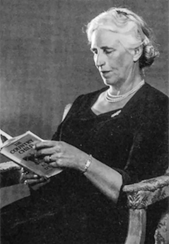
In the 1930s, countryside author Alison Uttley wrote a series of short essays based on her childhood experiences in and around Cromford. These were later produced in book-form by Scarthin Books. Currently out of print, it is possible to find a much-cherished second hand copy; armed with one of them, Brian Spencer looks for what became of the shops and businesses that once cared for the everyday needs of people living in Cromford over a century ago. Alison Uttley was born as Alice Taylor, on December 17th, 1884, at Castletop Farm, between Cromford and Lea Mills. A highly intelligent girl, she began her academic career by winning a scholarship at Lady Manners Grammar School in Bakewell. From there she went on to study Physics at Manchester University, taking an honours degree, one of the first women to enter the field of science. Following a teacher training course at Cambridge, she taught Physics and English in Fulham for three years before coming back to the North of England after marrying James Uttley. Moving to Buckinghamshire where she spent the rest of her life, her writing career began in 1931 when, as a widow she had to support herself and her infant son. Her first book was ‘The Country Child’, an autobiographical novel based on her early life as the daughter of a farming family. This was followed by much-loved children’s stories such as ‘Little Grey Rabbit’ and ‘A Traveller in Time’ and many other novels and plays, some of which have found their way on to the small screen. Although she never returned to Derbyshire, she began to write about her early experiences in and around Cromford. Here she would go by pony and trap with either her father and mother, or just the one, in order to buy their everyday needs, or have repairs made to the horse’s harness, or maybe watch while the farrier fixed the pony with a new shoe. Cromford in her time and well into the twentieth century, was a completely self-supporting village. It really did have the traditional Butcher, Baker and Candlestick maker, along with draper’s shops where Alison and her mother could buy a new bonnet. Her father could be measured and fitted with a new suit, or buy medicines for a sick cow. There was even a cobbler and a wheel-wright, in fact everything a busy village attached to Sir Richard Arkwright’s thriving cotton mill would need. Armed with a copy of the village map (see below), we soon discovered that while none of the businesses Alison or her parents relied on still exist, most of the buildings are still there sheltering other commercial interests, or even converted into private houses. Though the businesses have changed, the village is still laid out as it was in her day, and so our trip round Cromford was easy to follow. We started our walk round Alison Uttley’s Cromford with a late breakfast at the quirky wooden café that stands on the corner of Mill Road, above Arkwright’s Mill, where many of Cromford’s inhabitants made their living. Very little has changed with the café building apart from its use. In Alison Uttley’s time it was a barber’s shop, a place where the local men could socialise. Taking our lives into our hands we crossed the A6 and began to follow the left side of Cromford Hill Road. Beyond the small war memorial garden, the first building on our left is the Community Centre built on the site of the local flour Mill. A ladies’ hairdressing salon shares one corner, using what was once the village blacksmith’s place of work. Beyond a narrow gap a chip shop and cafe (one of two chippies supplying the village), fills what was once a post office, then comes a private house where there was a pork butcher’s shop, then later a bank. Beyond it Arkwright’s Store struggles against changing grocery needs, but next to it is probably the only unchanged shop in the village; this is the village newsagents where young Alison bought her penny dolls. Moving on up Cromford Hill, the next shop of interest comes next to a narrow drive accessing a group of cottages. This was where Alison and her mother bought ribbons to rejuvenate their hats. It later became a dress shop, but now looks after the requirements of the areas plumbers. Stone built houses line the road in a mixed selection of styles, many of them include a stocking frame knitter’s workshop in their upper stories. These cottages continue up to and beyond North Street, the street and school built by Richard Arkwright Junior to provide accommodation for his workers and stocking frame knitters. The street is built to give each side a fair share of sunshine, the north in the morning and south in the afternoon. Two commercial buildings stood at the entrance to North Street; on the left is the elegant bow front of what was once a butcher, but is now a private house. The Bell Inn is opposite, having partly extended into the grocer’s shop, once its next door neighbour. If anyone who lived lower down the hill wanted a loaf of bread they would have to climb to what is now the next door neighbour to the Bell, for that is where the village baker worked. Returning to the bottom of Cromford Hill, Water Lane carries quarry traffic along the Via Gellia. At the lane’s junction with the hill road, a general merchant uses part of the old carpenter and wheelwright’s workshop. An Aladdin’s Cave it fulfils D.I.Y needs and everything from sledges to wrought-iron display stands. It would have been well known to Alison’s father. Moving along Water Lane, past the closed Co-op shop that came and went after Alison Uttley’s time, the pond on your right gave power to Arkwright’s early mills. It also collected water draining from local lead mines: this was collected via a complicated system of channels behind the houses and shops at
In the footsteps of King Richard III
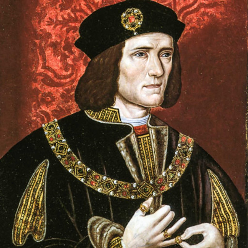
While we know the central and western parts of the Yorkshire Dales, the eastern edges alongside the Vale of York are, to say the least, a bit hazy to us. After doing a bit of research, we found that Richard spent his childhood and trained in knightly skills at Middleham Castle in the lower reaches of Wensleydale. These skills helped him take part in the battle of Tewkesbury (1471) aged just nineteen. It was at Middleham that he met and married Anne, younger daughter of the Earl of Warwick, head of the influential Neville family. Through that marriage young Richard eventually became owner of a whole range of castles, especially those guarding the eastern approaches to the Yorkshire Dales. It therefore seems likely that Richard had a special affection for Middleham, because he appears to have spent much time there, both in childhood and then as a family man, where his son Edward was born. It was this that coloured our decision to make a tour of the countryside Richard would have known so well. Our accommodation in Middleham was an attractive one-time cosy cottage in the shadow of the castle walls. Today, Middleham is home to around 500 young racehorses training for future glories on the flat. Each morning we watched them elegantly trotting away from the village, out towards the training gallops on the nearby Downs; perhaps we were admiring a future Derby winner. Middleham and its friendly locals, most of them involved with racehorse breeding, were always ready to chat over a socially distanced pint of Black Sheep in one of the three pubs; our favourite incidentally was the Richard III. The castle is just off the extensive old market square and is cared for by English Heritage. With the easing of lock-down the castle was open to prior bookings. As there is little or no Wi-Fi in Middleham, that took time, but we eventually managed to book a convenient visit. The castle has suffered as a ready-made source of building material over the centuries, but it still remains in remarkably good shape for its age. Three parts of the outer curtain wall are complete and the central keep could still echo with the sound of feasting lords and ladies enjoying life. There is a modern statue to King Richard inside the castle walls, but his most intriguing memorial is the worn lump of rock on a plinth at the top end of the market place. Although it takes more than a bit of imagination, this is all that remains of the carving of a wild boar, King Richard III’s emblem. Monasteries were at the height of the commercial power and influence during Richard’s lifetime. With their wealth built on wool and careful farming husbandry, lands around the Vale of York are home to a great number of monastic ruins. Attractive ruins the result of Henry VIII’s jealousy, are within easy driving distance of Middleham. We started our tour at Jervaulx Abbey, a short drive along the Ripon road from Middleham. Small by comparison with other abbeys, Jervaulx has attracted visitors over the centuries; the artist JMW Turner came this way while on a sketching tour in 1816. The main claim to fame though, is down to the early monks making the very first Wensleydale cheese. This forerunner of the cheese loved by Wallace and his faithful hound Grommit, was made from ewe’s milk, unlike today which traditionally is made from cow’s milk. Further along the Ripon road, the village of Masham is home to two breweries, both of which can be visited when things are different than today. Theakston’s is the oldest, dating from 1827, and Black Sheep Brewery is the other. Black Sheep was founded by Paul Theakston, fifth generation of master brewers in 1992 when the older company was bought out by one of the national brewing organisations. Travelling via Ripon, we arrived at Fountains Abbey bang on our previously booked time. The abbey is in the bottom of a wooded valley, secluded from car parks and Visitor Centre, but separated only by half a mile of winding path. If there was a competition for the most beautiful abbey ruins, then Fountains would be high on my voting list. No matter how many visitors there might be around once restrictions are removed, Fountains will remain a place of tranquil beauty, a place for quiet contemplation. It was founded in 1132 by a group of 13 disaffected monks who broke away from the mother church of St Mary’s Abbey in York. Here at Fountains they found what they were looking for, hidden from the world in a wild and wooded valley where living an austere life, they could follow a simpler and more devout existence. Members of the Carthusian Order, they were also known as the ‘white monks’ because of the undyed sheep’s wool habits they wore. Spending much of the day in contemplation and prayer, they also found time to develop skills as shepherds, tanners, master-builders and brewers. All these skills helped expand the abbey’s finance’s. By 1200 Fountains was one of the largest and most powerful houses in Britain. Despite damage by Henry VIII’s men who followed his dissolution edict, many of the abbey’s features remain virtually unspoilt, such as the gracefully arched cellars where freshly brewed ale was stored, to the appearance of its almost Victorian Gothic bell tower. A culverted stream which once provided water for the abbey’s needs, winds down the wooded valley for a little way before being slowed by a series of ponds and water gardens. This is part of Studley Royal, an attractive addition to Fountains Abbey created by John Aislabie and his son William in the eighteenth century. John was an over ambitious politician who fell from favour. As a result he retreated here and along with William, the pair managed to buy Fountains Abbey and set about designing the water gardens where their elegantly attired guests could stroll at leisure while